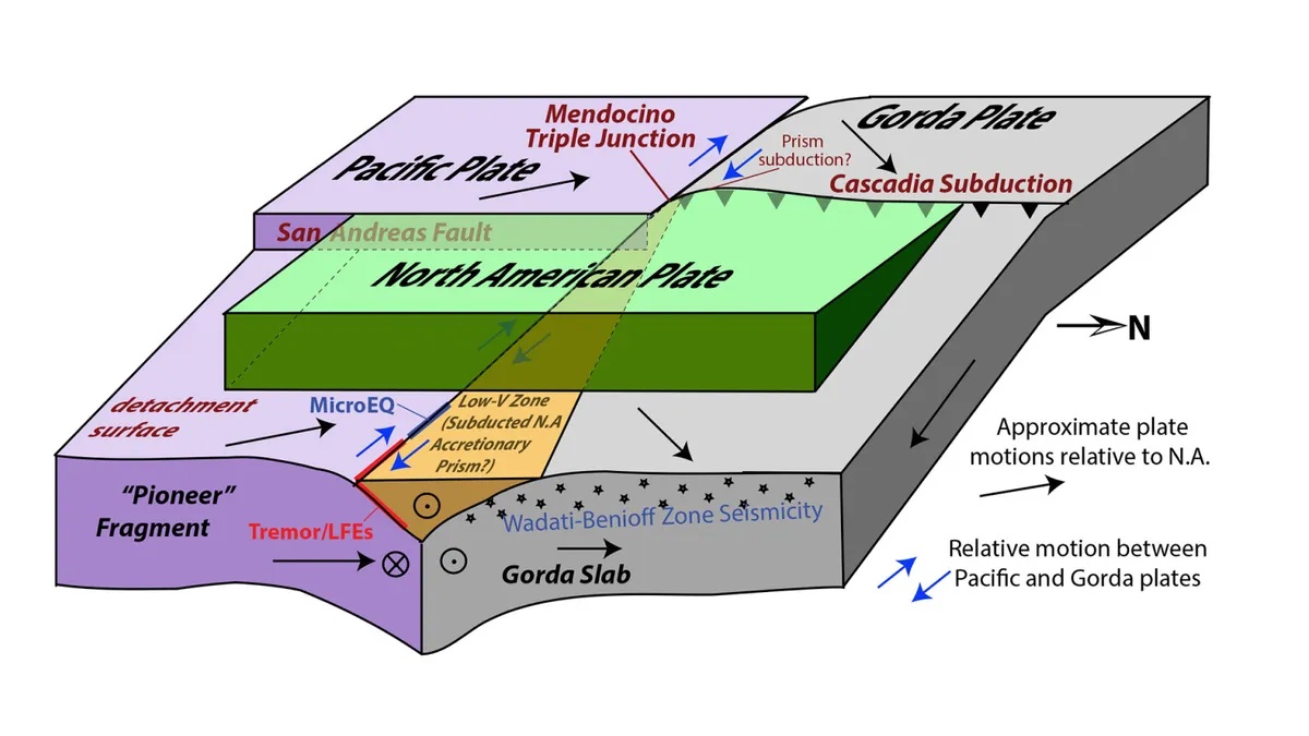
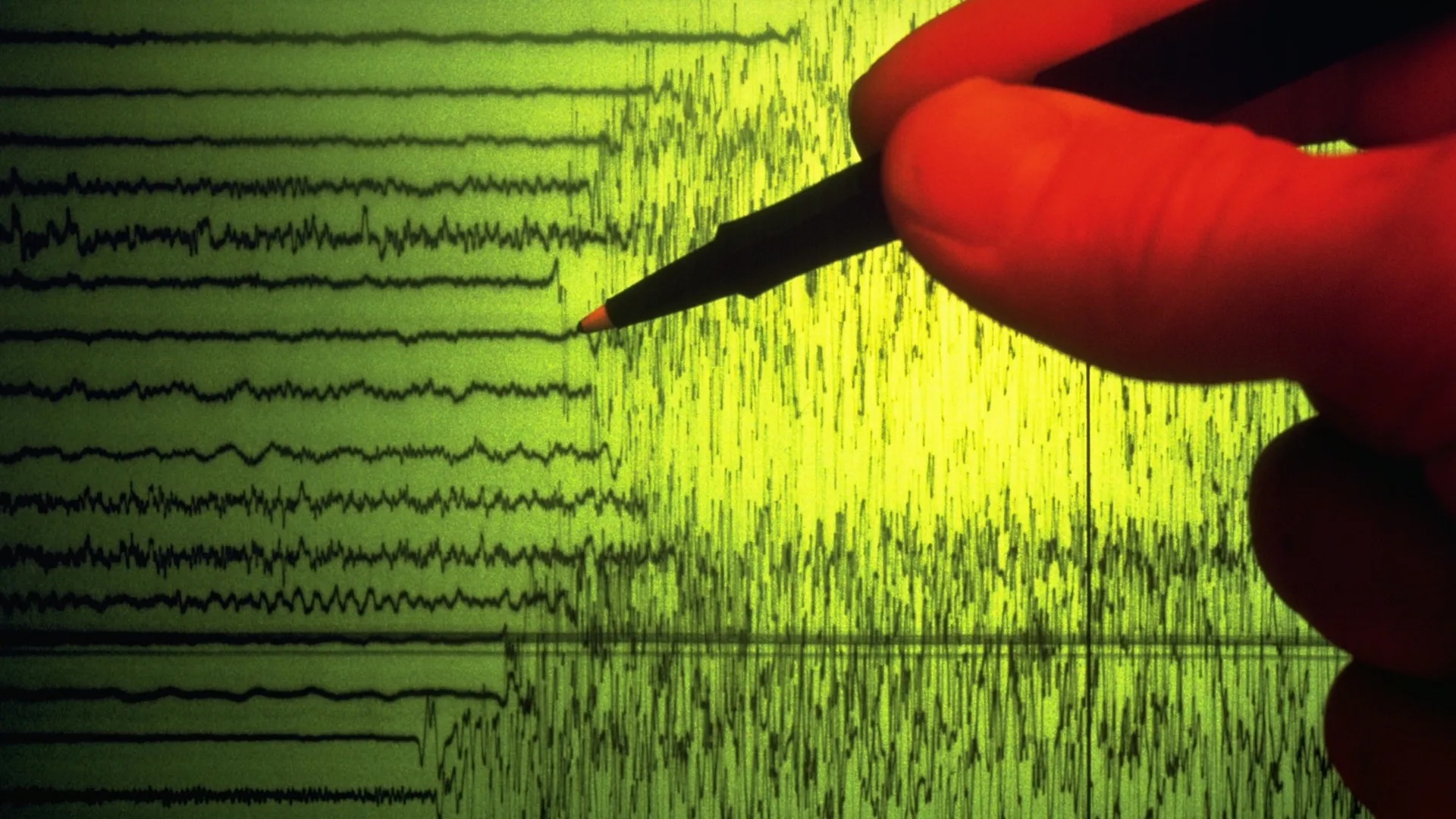
Fragment of lost tectonic plate discovered where San Andreas and Cascadia faults meet Live Science - January 16, 2026
A hidden chunk of an ancient tectonic plate is stuck to the Pacific Ocean floor and sliding under North America, complicating earthquake risk at the Cascadia subduction zone.
Scientists Discover a Hidden Earthquake World Beneath Northern California Science Daily - January 16, 2026

Invisible earthquakes are revealing a hidden tectonic puzzle beneath California's most dangerous fault zone.
Tiny earthquakes reveal hidden faults under Northern California PhysOrg - January 16, 2026
By tracking swarms of very small earthquakes, seismologists are getting a new picture of the complex region where the San Andreas fault meets the Cascadia subduction zone, an area that could give rise to devastating major earthquakes.
Magnitude 6.0 earthquake felt west of Oregon Coast KOIN News - January 16, 2026
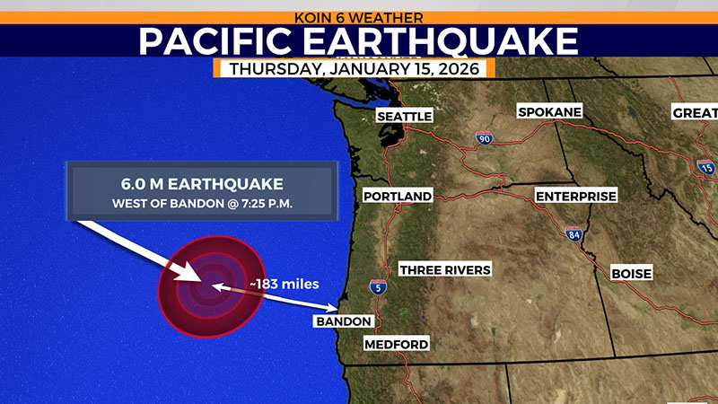
A magnitude 6.0 earthquake was recorded about 183 miles west of Bandon, Ore. Thursday afternoon. According to the USGS, the quake shook along the Cascadia Subduction Zone under the Pacific Ocean around 7:25 p.m. No tsunami threats were issued after the quake but some along the Oregon Coast might have felt some shaking.
The Pacific Plate is moving northwest forcing itself beneath surrounding plates and triggering intense seismic activity seen across Japan, the Kuril Islands, Kamchatka, and southern Alaska.
A powerful magnitude-7.5 earthquake struck off Japan's northeastern coast triggering evacuation orders and a tsunami warning for parts of the coastline. NBC - December 8, 2025

Very strong M7.0 earthquake hits near Yakutat shakes Southeast Alaska including Juneau and other towns in Alaska's northern and central panhandle - Watchers - December 7, 2025

Experiments reveal that minerals deep underground can rapidly fuse together after a seismic event, allowing faults to heal in surprisingly short times SciTech Daily - November 19, 2025

By recreating high-pressure, high-temperature conditions in the lab, researchers found that quartz grains can rapidly weld back together, restoring strength far faster than previously thought.
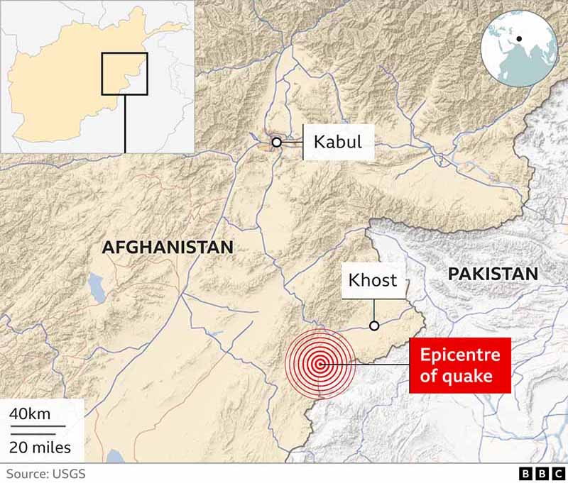
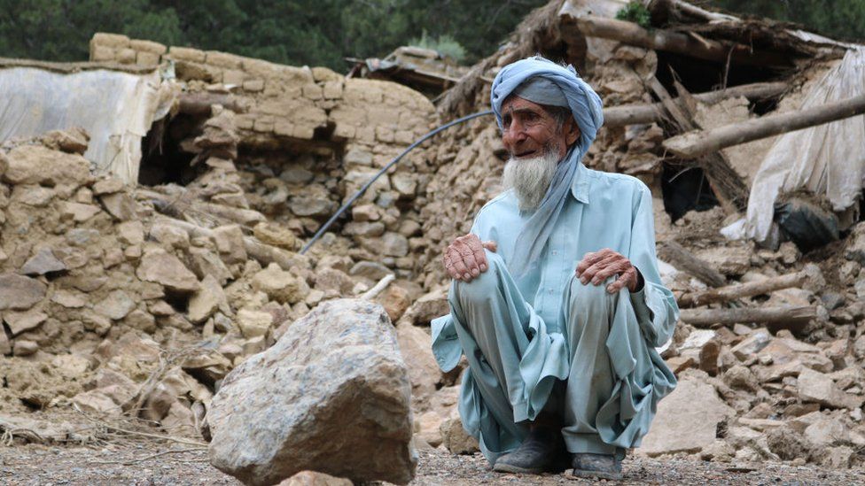
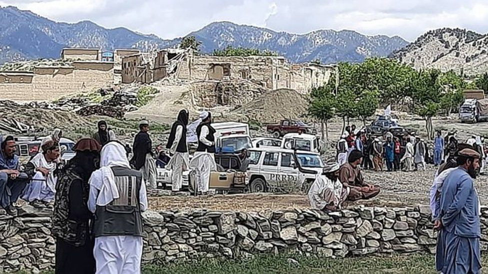
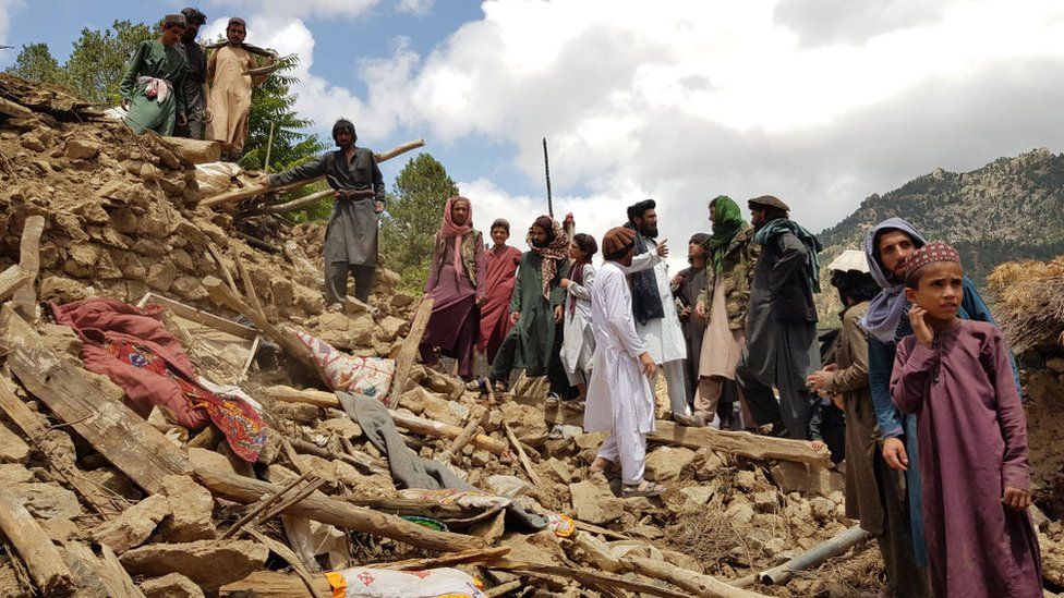
6.0 Earthquake shakes Afghanistan NBC - September 3, 2025

Over 1,400 killed and 3,124 injured - more than 5,400 homes destroyed with the numbers growing as rescue efforts continue.
3.0 Earthquake strikes Saturday night in New Jersey, rattling felt in NYC NBC - August 3, 2025
Comparing this earthquake to the 4.8 quake April 2024.
The quake hit at 10:18 pm - its epicenter Hasbrouck Heights, N.J., near Teterboro Airport, according to the Geological Survey. People reported feeling tremors in parts of New York City, including Brooklyn, as well as Westchester County and as far as Connecticut. People across northern New Jersey reported feeling a short, intense shake. Neighborhood chats and social media quickly lit up with some worried that a gas line had exploded or a large tree had fallen.
While the New York and New Jersey region experiences numerous tiny earthquakes every year, they usually go unnoticed, according to geologists. Earthquakes of 3.0 magnitude are not unusual for the area and rarely cause significant damage, experts say. The last significant earthquake in the region was in April last year, when a 4.8-magnitude quake shook buildings in New York City and drove startled residents into the streets. Its tremors were felt from Philadelphia to Boston.
Three days later

2025 Kamchatka Peninsula Earthquake Wikipedia
Southern Kamchatka shifted 6.6 feet during M8.8 earthquake The Watchers - August 5, 2025
Tsunami waves hit US shores after 8.8 magnitude quake strikes Russia's far east - 6th most powerful ever recorded CNN - July 30, 2025
How a Giant Earthquake Triggered a Surprisingly Small Tsunami Science Alert - July 30, 2025
Why the Pacific tsunami was smaller than expected: A geologist explains PhysOrg - July 30, 2025
The region is known for seismic activity due to its location in the Pacific Ring of Fire - a belt in the Pacific where the world's most active volcanoes are located.
Russian volcano explodes in 'powerful' eruption, likely intensified by 8.8 magnitude earthquake Live Science - July 30, 2025
A volcano on Russia's far eastern Kamchatka Peninsula erupted overnight into Sunday for what scientists said is the first time in hundreds of years and days after the massive 8.8-magnitude earthquake last week PhysOrg - August 4, 2025

A parade of volcanoes is erupting in Russia following an 8.8 earthquake Live Science - August 5, 2025

The 8.8 pacific earthquake could have affected this predicted event ... Undersea Volcano Off The US West Coast Predicted To Erupt In 2025
Climate change and natural disasters continue to accelerate exponentially as we move to closure. This summer has seen unprecedented global flooding and extreme heat. All of the tectonic plates are broken or fractured highlighted with the Pacific Plate.
Massive Earthquake Could Strike Canada as Ancient Fault Line Wakes Science Alert - August 1, 2025
The Tintina fault stretches 1,000 kilometers (621 miles) across northern Canada, crossing the Yukon and ending in Alaska. The fault is thought to have been dormant for 40 million years, but that thinking is challenged by a new study that suggests a major earthquake may be imminent. Researchers have spotted signs of two relatively recent groups of earthquakes that significantly shifted the ground: one 2.6 million years ago and one 132,000 years ago.
'Sleeping giant' fault beneath Canada could unleash a major earthquake, research suggests. A new assessment of the enormous Tintina fault suggests it has been slowly accumulating strain over thousands of years Live Science - August 1, 2025
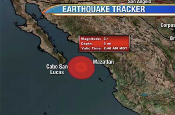
Map: 6.3-Magnitude Earthquake Strikes Colombia June 8 at 8:08 New York Times - June 8, 2025
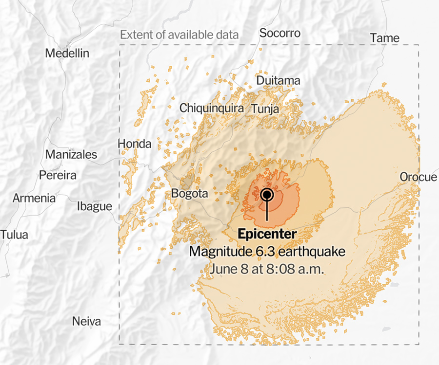
The temblor happened at 8:08 a.m. Colombia time about 72 miles east of Bogota, Colombia, data from the agency shows. As seismologists review available data, they may revise the earthquake's reported magnitude. Additional information collected about the earthquake may also prompt U.S.G.S. scientists to update the shake-severity map.
Cairo, Egypt among other countries felt an earthquake that struck earlier today measuring 5.8 on the Richter scale Egypt Today - June 8, 2025

The earthquake struck south of the Turkish border confirming that the epicenter was approximately 600 kilometers from the city of Marsa Matrouh and that there have been no destructive effects within Egyptian territory so far. The earthquake was felt by residents of Greater Cairo, the Delta, Alexandria, and Marsa Matrouh. The current situation is stable with no reports of human or property damage.
The earthquake was widely felt, with over 30,000 reports submitted by the public in the first hour after it happened according to USGS . Because of the geology in the eastern US, seismic waves spread more efficiently than they do in the western part of the country, and earthquakes are felt over a much larger distance and by more people. There is a 5% chance of a magnitude 4 or larger aftershock occurring in the next week, according to USGS Operational Aftershock Forecasts.
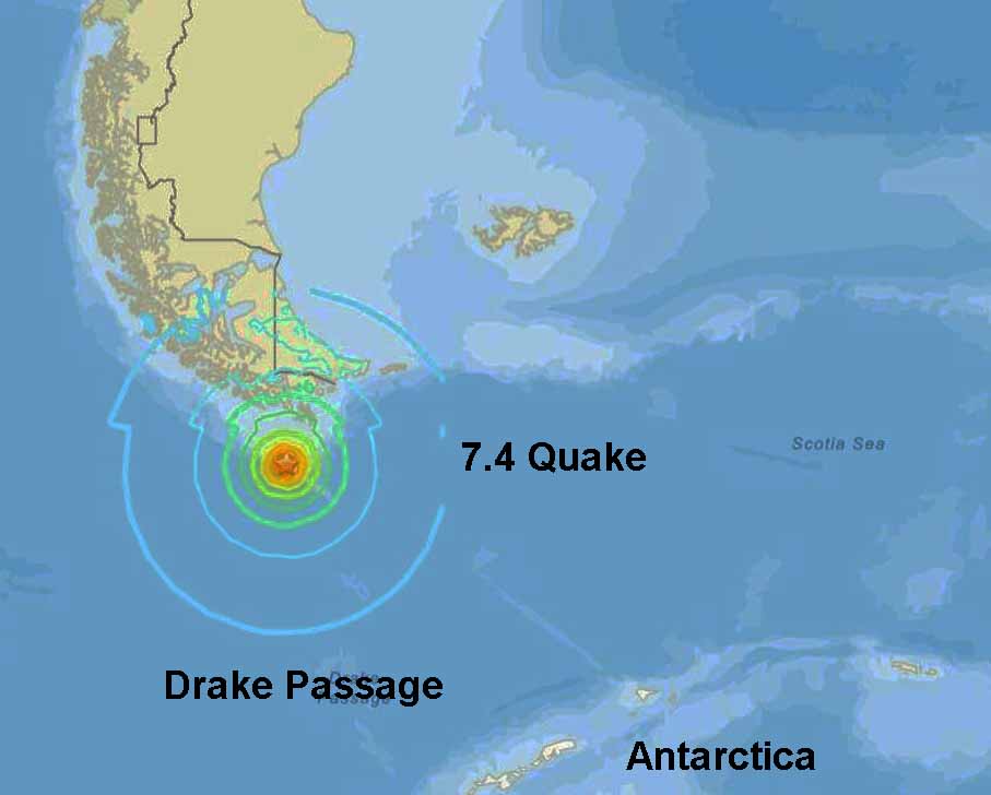
A very strong earthquake M7.4 hit Drake Passage, near the coast of southern Argentina. Chile lowers alert after quake triggers tsunami alert and evacuations in Antarctica and far south. Watchers - May 2, 2025

Axial Seamount showing signs of approaching eruption as magma builds up off Oregon coast Watchers - May 1, 2025
Axial Seamount, an underwater volcano off the Pacific Northwest coast, could erupt soon for the first time in a decade. Scientists at the University of Washington have detected a sharp increase in small undersea earthquakes and seafloor inflation - signs of magma buildup within the volcano. Despite the activity, experts say there is no threat to coastal communities. The site remains under constant observation through one of the world�s most advanced ocean monitoring systems.
'The Big One' could rock the Pacific Northwest and fuel sea-level rise and massive flooding Live Science - May 1, 2025
A catastrophic earthquake in the Cascadia region of the Pacific Northwest could lower the ground near the coast by up to 6.6 feet (2 meters). Combined with rising seas caused by climate change, that could create long-term flooding problems for coastal areas in northern California, Washington and Oregon, a new study finds. Such a quake would triple the amount of land in the 100-year floodplain in the Pacific Northwest by 2100, according to the study. "We talk a lot about the tsunami and about the shaking, but this subsidence could persist for decades to centuries.
AI-powered monitoring detected over 50,000 earthquakes during intense seismic crisis in Santorini, Greece Watchers - April 15, 2025
Researchers at the 10th Delphi Economic Forum on April 13, 2025, revealed that the use of advanced machine learning technology enabled them to detect over 50,000 earthquakes in Santorini, some of which occurred before the intense earthquake swarm in February 2025. This early detection enhanced earthquake forecasting and improved warning procedures during the crisis.
5.2 Earthquake near Julian brings widespread shaking across Southern California. Dozens of aftershocks were reported CNN - April 14, 2025

The quake was preceded by a 3.3 magnitude foreshock just before 4 p.m. Sunday, Dr. Lucile Jones, a seismologist working with Caltech, said on a call following the quake. Jones said the quake seems to be associated with the Elsinore fault line.
Video shared by the San Diego Zoo shows the moment a group of elephants huddle to protect their young during the 5.2 Julian earthquake in San Diego county BBC - April 15, 2025
The behavior is known as an 'alert circle', a formation meant to protect calves from threats.
In the aftermath of the 2004 Indian Ocean earthquake and tsunami, reports indicated that elephants in Indonesia and other affected areas showed unusual behavior, including fleeing the coast for higher ground before the tsunami waves reached land. Some elephants even managed to escape or even break free from restraints. While the specific details of elephant behavior during the 2003 earthquake in Indonesia are not widely documented in the search results, the 2004 tsunami event highlights elephants' potential ability to sense and react to seismic disturbances and subsequent natural disasters like tsunamis.

March 28, 2025 - April 4, 2025
Seven reciprocal earthquakes in the Atlantic and Pacific regions continued consecutively for one week - rocking the planet and whose after-effects are not as yet known. (More details below this list)
It all started here ...2025 Myanmar 7.7 earthquake
Strong shallow M6.6 earthquake hits central Mid-Atlantic Ridge
Shallow M6.3 earthquake hits Pacific-Antarctic Ridge
7.0 Earthquake strikes near Pacific island nation Tonga, days after deadly Myanmar quake
Very strong M6.9 earthquake hits Reykjanes Ridge (Iceland)
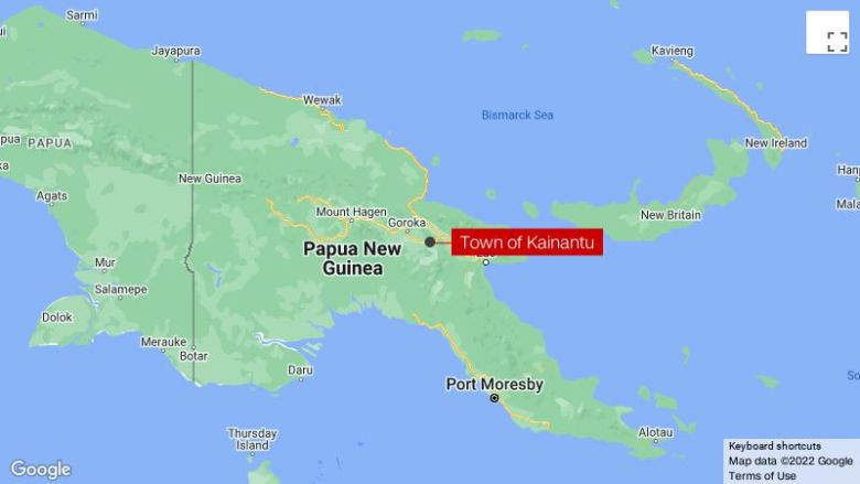
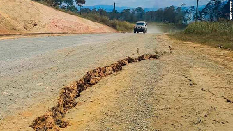
Very strong M6.9 earthquake hits Papua New Guinea, hazardous tsunami waves possible
Tsunami threat for Papua New Guinea after 6.9 magnitude earthquake ABC - April 4, 2025
Very strong M6.9 earthquake hits Papua New Guinea, hazardous tsunami waves possible Watchers - April 4, 2025

Very strong M6.9 earthquake hits Reykjanes Ridge Watchers - April 3, 2025


A major 6.0 earthquake hit Japan's Kyushu on Wednesday evening, days after Myanmar and Thailand witnessed dramatic tremors of magnitude 7.7 Times Now - April 3, 2025

The shockwaves were felt in several countries, including India, China, and Bangladesh. Buildings collapsed like a pack of cards, and roads cracked as powerful tremors wreaked havoc in Myanmar and Thailand. More than 3,000 people died in the earthquake, while thousands of others were left injured.
Shallow M6.3 earthquake hits Pacific-Antarctic Ridge Watchers - April 2, 2025

The epicenter was located 2 760 km (1 715 km) ESE of Waitangi, New Zealand. There was no tsunami threat from this earthquake.
Friday March 28, 2025 - Two Major Earthquakes - On Opposite Sides of the Planet

March 28, 2025 - Myanmar 7.7 Earthquake Wikipedia
Pics: Human devastation from Mandalay to Thailand's capital, Bangkok


Strong shallow 6.6 earthquake hit central Mid-Atlantic Ridge
About the Mid-Atlantic Ridge and Related

CBS News - 7.1 Earthquake strikes near Pacific island nation Tonga, days after deadly Myanmar quake
The Sun's Activity Can Trigger Earthquakes, And Now We Know How Science Alert - March 4, 2025

Solar heat drives atmospheric temperature changes, which in turn can affect things like rock properties and underground water movement. uch fluctuations can make rocks more brittle and prone to fracturing.
Scientists record never-before-seen 'ice quakes' deep inside Greenland's frozen rivers Live Science - February 14, 2025

Similar to earthquakes, ice quakes are seismic events that can happen in ice when it fractures and two slabs grind against each other.

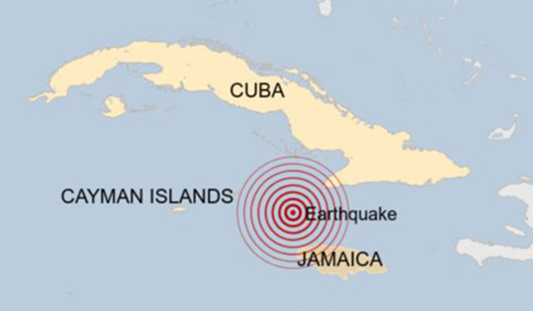
Tsunami warnings issued after a powerful 7.6-magnitude earthquake rocked the Caribbean Sea have been canceled BBC - February 9, 2025
A magnitude 7.6 earthquake struck in the western Caribbean on Saturday night, prompting a tsunami advisory for the Cayman Islands as Puerto Rico and the U.S. Virgin Islands were cleared of the threat NBC - February 9, 2025
Officials say the earthquake's epicentre was about 20 miles (32.1km) north of Honduras and 130 miles (209.2km) south-west of the Cayman Islands when it struck on Saturday evening local time. The quake was the biggest to hit the region since 2021, when a 7.2 magnitude earthquake struck Haiti. About three hours after the earthquake, US authorities warned that "minor sea level fluctuations" of up to 30cm (11.8 inches) could still occur, but that any serious threat had passed.

Santorini, a Greek island, is steeped in myths and legends that are rich with spiritual significance. The island's volcanic origins, dramatic caldera, and connection to the myth of Atlantis have captivated people's imaginations for centuries.
February 7, 2025 - An earthquake swarm that began on January 27 has now produced over 1,000 individual events some stronger than 5.0 magnitude. Most tourists and many Santorini residents have evacuated and are watching from afar, wondering what is going to happen. Are these quakes the harbingers of a really big one? Or could these sorts of near-constant quakes just continue for weeks or even months? The existence of the island's two volcanoes also gives rise to another layer of tension: Could this near-constant rumbling finally rouse them from a slumber that has lasted 75 years?
The seismic activity rattling Santorini and other Greek islands is not over and the biggest quake yet could be still to come CNN - February 7, 2025
State of emergency declared on Amorgos, second Greek island after Santorini, as undersea earthquakes continue Watchers - February 14, 2025
Santorini fears for summer tourist season as earthquakes hit island BBC - February 14, 2025
This article about plate tectonics totally connected for me. It's the place where the Tigris and Euphrates Rivers meet - a mountain range that starts with the letter "Z" - the Cradle of Civilization - and the first landing place of the Anunnaki when Earth was terraformed.
Ancient Oceanic Plate Rips Apart Beneath Iraq and Iran. In the past sediments eroded from the Zagros mountains forming plains such as Mesopotamia. SciTech Daily - February 4, 2025
https://www.livescience.com/planet-earth/geology/ocean-plate-from-time-of-pangaea-is-now-being-torn-apart-under-iraq-and-iran Live Science - February 8, 2025
Rare M3.8 earthquake hits Maine, felt in Boston and beyond CNN - January 28, 2025

The quake was centered about 7 miles southeast of York Harbor, Maine, and struck at a depth of about 8 miles, the USGS said. Earlier, the USGS estimated the magnitude was 3.9.
Wikipedia: January 7, 2025 Tibet 7.1 earthquake

The earthquake also injured 13 people in Nepal and caused minor damage in northern India. Shaking was felt across South Asia. The earthquake was the largest in China since the Maduo earthquake in May 2021 and the deadliest since the Jishishan earthquake in December 2023. It was caused by normal faulting and originated within the continental crust at 10 km (6.2 mi) depth.
Unexpected And Unexplained Structures Found Deep Below The Pacific Ocean Live Science - January 8, 2025
Geoscientists have used earthquakes to study the composition of the lower portion of the Earth�s mantle under the Pacific Ocean � and they've discovered something quite peculiar. There are zones where the seismic waves move in different ways, suggesting structures that are colder or have a different composition than the surrounding molten rocks. The team describes the presence of these structures as a major mystery. It is unclear what these structures are. If they were anywhere else, they could be portions of tectonic plates that have sunk in a subduction zone. But the Pacific is one large plate, so there should be no subduction material under it. The researchers are also uncertain about what kind of material these deep structures are made of or what this means for the internal structure of the planet.

9.3 Indian Ocean Earthquake triggered a tsunami that killed 230,000 people
20 years after the 9.3 earthquake and subsequent tsunami in Sumatra, Indonesia BBC - December 26, 2024
20 years after a devastating tsunami, a survivor celebrates what the disaster has given him BBC - December 26, 2024
Buildings flattened as 7.3 magnitude earthquake hits Vanuatu BBC - December 17, 2024
Widespread damage, casualties reported after major M7.3 earthquake hits Port-Vila, Vanuatu Watchers - December 17, 2024
Vanuatu sits on the Pacific Plate, with the movement of the Indo-Australian Plate subducting beneath it, creating an active tectonic zone known as the Vanuatu Subduction Zone.
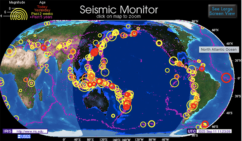
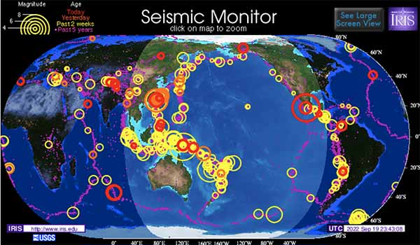
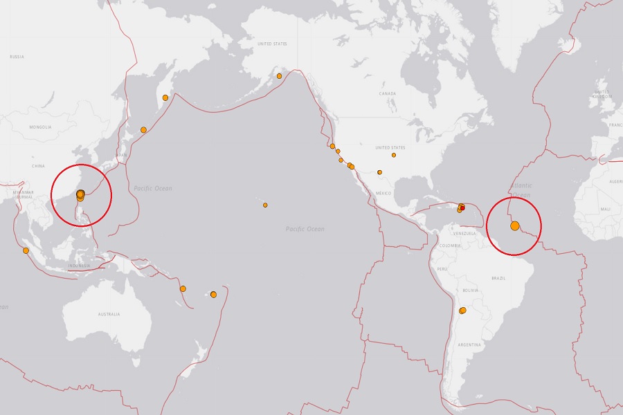
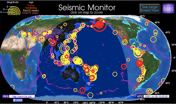
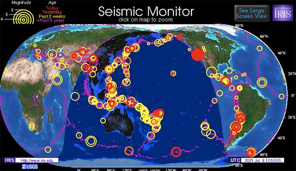
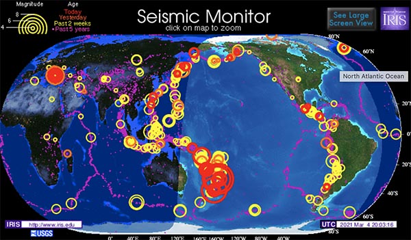
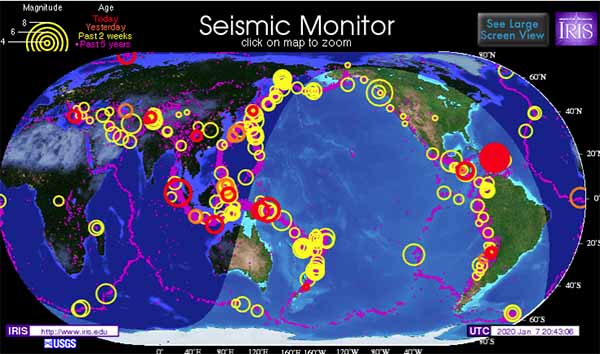
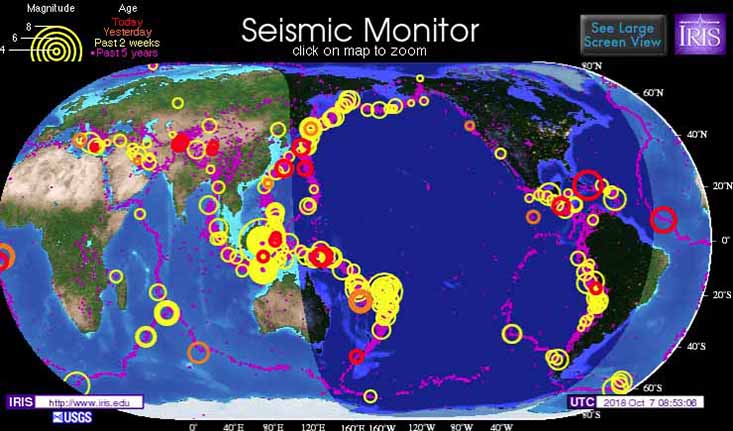
It seems the Pacific Plate is on the move again - north, south, east, and west. Its activity should not be ignored - just monitored when you see a big red circle on the map at the top of this page.
Twenty years ago - on Boxing Day December 26, 2004 - you might remember the 2004 Indian Ocean earthquake and tsunami - a major earthquake with a magnitude of 9.3 and an epicentre off the west coast of northern Sumatra, Indonesia.

I'm remembering a connection between closure of this simulated reality and the Papua New Guinea Tsunami on July 17, 1998 as told to me when I posted on that date. The earthquake occurred along the boundary of the Australian and the Pacific tectonic plates after a massive underwater landslide occurred.
An earthquake swarm has been occurring southwest of Adak Islands, Alaska, since December 8, 2024 Watchers - December 9, 2024
The Aleutian Islands, including Adak Island, are located on the North American plate, which is being subducted (the sideways and downward movement of the edge of a plate of the earth's crust into the mantle beneath another plate) by the Pacific plate. This comes two days after a series of earthquakes caused evacuations across hundreds of miles in northern California and Oregon.
A 6.8 magnitude earthquake struck off the coast of eastern Cuba on Sunday CNN - November 11, 2024
The earthquake caused material damage in several regions as the island continues to recover from widespread blackouts and the impact of two hurricanes over the past few weeks. There have been landslides, damage to homes and power lines. The earthquake was reported about 39 km (24 miles) south of Bartolome Maso before noon local time, about an hour after a 5.9 magnitude quake rocked the area, the United States Geological Survey (USGS) said.
LA's quake mystery: 2024 brings the most seismic activity in decades. Why now? PhysOrg - October 11, 2024

The ground beneath Southern California has been particularly unsteady as of late, with the region experiencing more moderate-sized earthquakes this year than it has in decades. What precisely is fueling the sequence of shakers is not entirely clear, and officials warn that prior seismic activity does not necessarily mean more powerful temblors are imminent. But the series of modest shakers have many wondering what is going on.
Record spike in earthquakes at Washington's 'high threat' Mount Adams volcano sends researchers scrambling for answers Live Science - October 5, 2024
Six earthquakes were recorded at the Mount Adams volcano in September - a significant increase on the normal rate of one every two to three years.
Giant oarfish: The 'doomsday' fish of legend that supposedly foreshadows earthquakes Live Science - September 7, 2024
According to Japanese myth, oarfish are harbingers of earthquakes, and their appearance signals a tremor could be about to hit. In traditional Japanese legend, oarfish were known as "ryugu no tsukai" meaning "the messenger from the sea dragon god's palace." People believed oarfish would come up from the deep to warn people when an earthquake was imminent. This myth caused a stir in 2011 when 20 oarfish washed ashore in the months before Japan was struck by the country's most powerful earthquake.
Electricity generated by earthquakes might be the secret behind giant gold nuggets PhysOrg - September 7, 2024

The standard explanation is that gold precipitates from hot, water-rich fluids as they flow through cracks in the Earth's crust. As these fluids cool or undergo chemical changes, gold separates out and becomes trapped in quartz veins. The research team tested a new concept, piezoelectricity. Quartz, the mineral that typically hosts these gold deposits, has a unique property called piezoelectricity - it generates an electric charge when subjected to stress. This phenomenon is already familiar to us in everyday items like quartz watches and BBQ lighters, where a small mechanical force creates a significant voltage. What if the stress from earthquakes could do something similar within the Earth?
Shiveluch Volcano erupts in Russia after 7.0-magnitude earthquake, sending ash column 5 miles high CNN - August 18, 2024

A volcano has erupted following a 7.0-magnitude earthquake that struck off Russia�s east coast, spurting a column of ash miles into the air, according to state-run media. The Shiveluch volcano is around 280 miles from Petropavlovsk-Kamchatsky, a coastal city with a population of about 180,000 that lies in Russia�s eastern region of Kamchatka.
Earthquake scientists are learning warning signs of 'The Big One.' When should they tell the public? NBC - August 18, 2024
When Japan issued its first-ever megaquake warning last week, Harold Tobin, Washington state�s seismologist, was watching carefully. The advisory came after a 7.1-magnitude earthquake struck the southern island of Kyushu. Although that shaking caused little major damage - the biggest tsunami wave it produced would have risen up to your knee - it wasn't the main worry. Rather, seismologists were concerned that the quake would create stress that could trigger a bomb ticking offshore: Japan's Nankai trough, likely the country's most dangerous fault. The subduction zone has the potential to generate 100-foot-tall tsunami waves and kill nearly a third of a million people, according to Japanese government estimates.
Magnitude 4.4 earthquake shakes Los Angeles CNN - August 12, 2024
The shallow quake was only 7.5 miles deep and directly under the populated areas of Los Angeles, so was likely felt widely despite the relatively modest intensity. The shallow quake was 7.5 miles deep and directly under the populated areas of Los Angeles, so was likely felt widely despite the relatively modest intensity.
The fault system suspected to be responsible for this week's 4.4 magnitude quake poses a bigger threat to the city than its better-known counterpart, seismologists say. Watch the video
7.2 magnitude earthquake shakes southern Peru PhysOrg - June 28, 2024
The earthquake was felt in the nearby regions of Ayacucho, Ica, and the capital, local media reported. Eder Allca, the mayor of the district of Sancos, in the Ayacucho region, told the local radio station RPP that a road in his district suffered rock slides that left several localities cut off.
Odd earthquake swarm in Central Europe hints at magma bubbling below the surface Live Science - May 11, 2024

An odd earthquake swarm has struck the region between the Czech Republic and Germany, far from any tectonic plate boundary. The quakes are in Vogtland, a region known for regular, low-level earthquake swarms. These swarms tend to last several weeks and lead to mostly mild shaking. The largest known quakes from the area are around magnitude 4.5.
Part Of The San Andreas Fault Might Be Waking Up - Could Earthquakes Loom? IFL Science - April 10, 2024
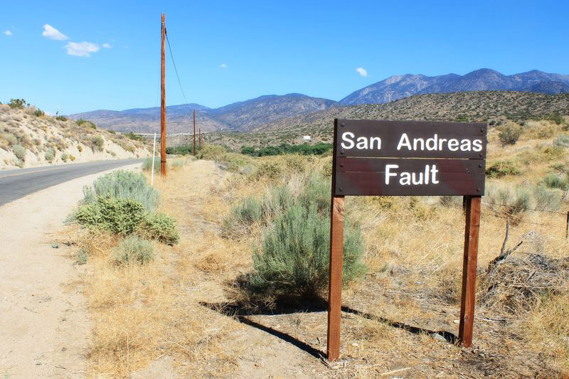
Seismologists suspect earthquake on San Andreas Fault is imminent despite odd attenuation parameters PhysOrg - April 10, 2024
A trio of seismologists affiliated with Ithe Berkeley Seismological Laboratory reports that a part of the San Andreas Fault, at Parkland, is not producing signals that would suggest an earthquake is going to happen any time soon, but they assert there are factors that suggest otherwise.
7.4 magnitude quake hits Taiwan, strongest in 25 years CNN - April 3, 2024
7.4 Hualien, Taiwan Earthquake

At least nine people have died after a 7.4 magnitude earthquake struck the east coast of Taiwan on Wednesday. Rescuers are working to free dozens trapped after the quake caused landslides and collapsed structures. More than 900 others are injured and over 100 buildings have been damaged. The quake was followed by strong aftershocks, including a 6.5 magnitude tremor. Multiple aftershocks as strong as magnitude 7 are expected in the coming days. Taiwan, Japan and the Philippines have all canceled tsunami warnings issued after the quake hit.
2,000 earthquakes in 1 day off Canada coast suggest the ocean floor is ripping apart, scientists say. Record earthquake activity off the coast of Vancouver Island hints at the birth of new oceanic crust Live Science - March 23, 2024
Intense Seismic Shakes Off Canada's Coast May Be Forming New Seafloor. Over 200 earthquakes per hour have recently been recorded offshore of Vancouver Island IFL Science - March 23, 2024
Confusing Jumbles of Rocks in Africa Could Represent Oldest Known Earthquakes Science Alert - March 15, 2024
Oldest evidence of earthquakes found in strange jumble of 3.3 billion-year-old rocks from Africa Live Science - March 15, 2024
Scientists have found signs of some of the earliest known earthquakes in 3.3 billion-year-old rocks. The rocks provide early evidence of plate tectonics, which explains Earth's crust as split into large plates that glide across the mantle. The rocks also point to what conditions may have been like when life first evolved. Geologists made the discovery after investigating the Barberton Greenstone Belt, a complex geological formation in southern Africa. They realized that the belt is remarkably similar to much younger rocks in New Zealand that have experienced earthquake-triggered submarine landslides along the Hikurangi subduction zone.
Strange seismic wave arrivals lead to discovery of overturned slab in the Mediterranean PhysOrg - February 24, 2024
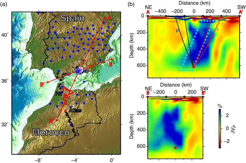
Strange seismic wave arrivals from a 2010 earthquake under Spain were the clues that led to an unexpected discovery beneath the western Mediterranean: a subducted oceanic slab that has completely overturned.
The Seattle fault zone is a network of shallow faults slicing through the lowlands of Puget Sound, threatening to create damaging earthquakes for the more than four million people who live there PhysOrg - February 6, 2024
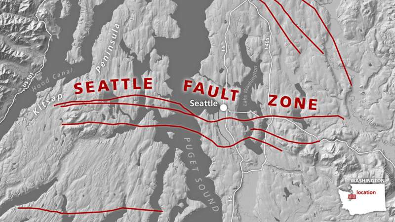
A new origin story, proposed in a new study, could explain the fault system's earliest history and help scientists improve hazard modeling for the densely populated region. The study is published in the journal Tectonics. The Seattle fault is active today because of forces exerted on the region from ongoing tectonic deformation both to the west and south, but that was not always the case. Washington in the Eocene looked different from today, with a coastline well east of where Seattle sits today and a chain of volcanic islands dotting the horizon offshore.
Geoscientists find Pacific plate is scored by large undersea faults that are pulling it apart PhysOrg - February 6, 2024
A team of geoscientists is shedding new light on the century-old model of plate tectonics, which suggests the plates covering the ocean floors are rigid as they move across the Earth's mantle. Researchers found that the Pacific plate is scored by large undersea faults that are pulling it apart
Nearly 75% of the US is at risk from damaging earthquakes, new map reveals
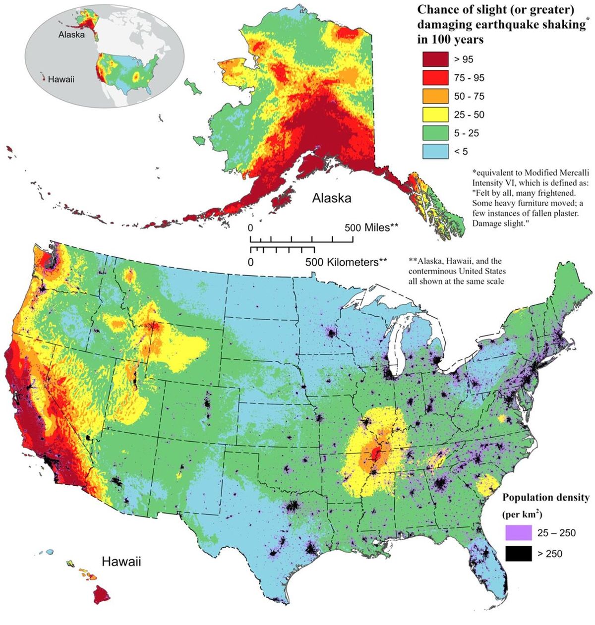
The update map includes more faults, better-characterized land surfaces, and computational advancements in modeling that provide the most detailed view ever of the earthquake risks we face.
BBC Videos: 48 dead as Japan earthquake leaves homes flattened and roads torn apart. More than 150 aftershocks BBC - January 1, 2024

A pregnant woman has died, four people injured, and nine are missing after a powerful 7.6 earthquake hit the Philippines' second-largest island of Mindanao followed by four major aftershocks exceeding 6.0 BBC - December 2, 2023
7.6 magnitude earthquake off Philippines prompts evacuations more than 1,000 miles away USA Today - December 2, 2023
6.3 earthquake hit Afghanistan Sunday CNN - October 15, 2023
A powerful 6.3-magnitude earthquake struck Afghanistan on Sunday just days after another deadly quake devastated its western Herat province. With the region already reeling from recent seismic activity, global aid groups and rescue teams say the country is now facing an escalating humanitarian crisis, on top of war and a collapsed economy. Taliban government officials estimate that more than 2,000 people across Herat province have been killed; more than 90% of those were women and children, according to UN agencies and officials on the ground.
On this date Hamas attacked Israel. Earlier in the week, Kevin McCarthy was voted out as Speaker of the House. Chaos continues.

When life is reduced to rubble.
Taliban says close to 2,000 people have died in 6.3 quake that struck western Afghanistan Saturday CNN - October 7, 2023
Two large earthquakes hit western Afghanistan four days apart, killing more than 1,300 people. The United Nations called it a "disaster on top of a disaster" in a nation still reeling from decades of war.
After Mexico, Afghanistan quakes, Papua New Guinea also struck by 6.7 earthquake Geo News - October 9, 2023
Earthquakes: Papua New Guinea, Mexico, Afghanistan Daily Mail - October 9, 2023
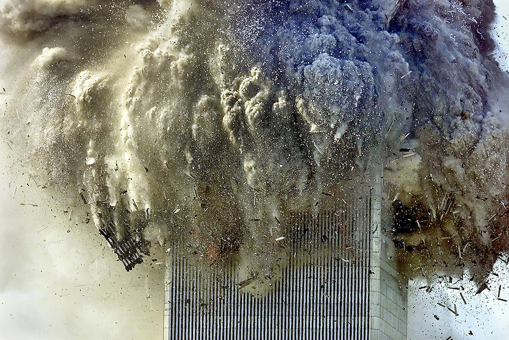

9/11 Crystalinks Files Personal accounts, pics, spirits, more
Today the world remembers 9/11. I have so many memories from that day. When you live through an insert and reboot in the simulation of reality - it's not hard to bring those events into the forefront of your consciousness and understand events from a more advanced perspective as time passes.
I remember standing on my terrace watching the second plane hit the South Tower and thinking the scene was surreal as I took pics with my new Canon camera. 9/11 is a never ending story as more human remains have been recently been identified.
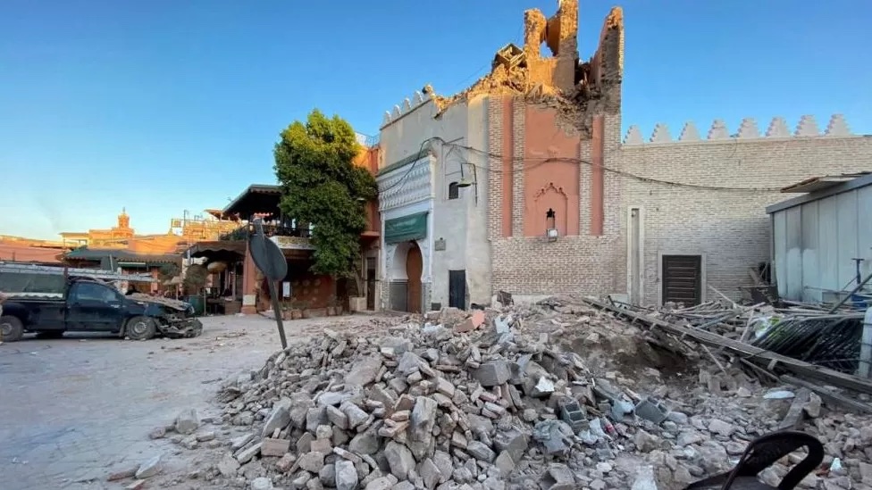
Smoke and debris-filled pics from 9/11 remind me of Friday's 6.8 earthquake in Morocco as well as scenes from the current war between Russia and Ukraine - what once symbolized life and society reduced to rubble and human suffering.

5.9 magnitude earthquake hit Central Mid-Atlantic Ridge
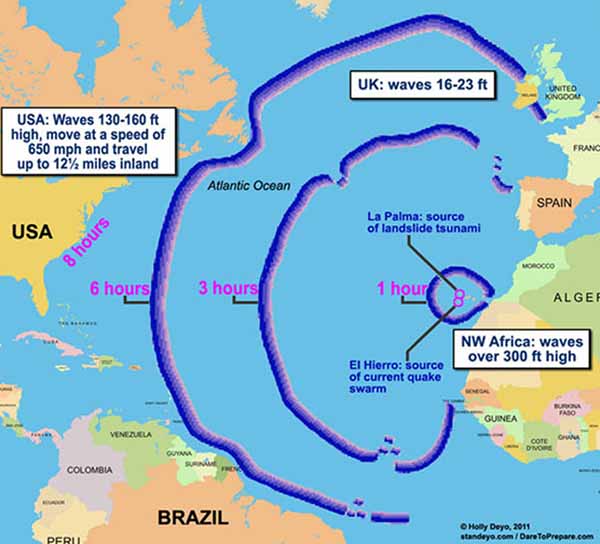
I don't know about you guys but when Friday's 6.8 earthquake hit Morocco my first thought was how close that was to the Mid-Atlantic Ridge and End Time Theories connected to the La Palma Canary Islands Mega-Tsunami Theory. I checked on the movement of the Mid-Atlantic Ridge ... and yes, it is rising faster than ever.
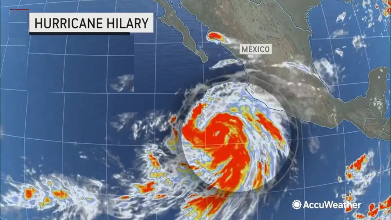
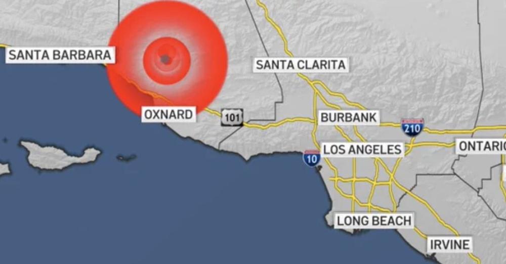
Tropical Storm Hilary, the first to cross into California in 26 years, pounded the southern part of the state with swollen rivers, flash flooding, flooded roads, mudslides and more. Authorities reported multiple water rescues, power outages and road closures as a state of emergency was declared for much of the region. During the storm a 5.1 magnitude earthquake hit Southern California - the combined events called a "Hurriquake" - though they were reported as non-related.
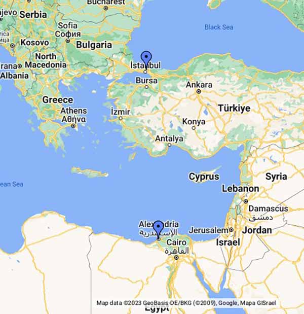
Wikipedia: 2023 Turkey-Syria Earthquakes
A Seismologist Explains The Science of The Devastating Turkey-Syria Earthquake
The earthquakes were felt as far away as Egypt.
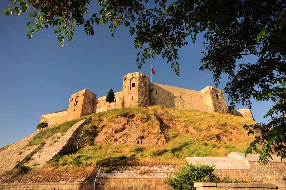
Turkey's 1,800-Year-Old Gaziantep Castle Wrecked By Devastating Earthquake
Video Reportedly Shows Birds Acting Strangely Prior To The Earthquake In Turkey IFL Science - February 9, 2023

3.8 magnitude earthquake rattles the Buffalo, New York, area CNN - February 7, 2023
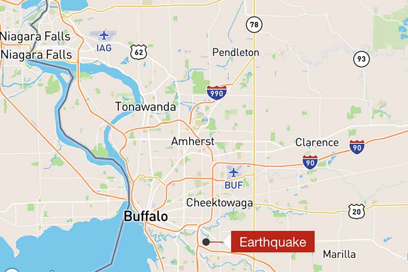
The quake struck around 6:15 a.m. and was centered just over a mile northeast of West Seneca at a depth of about 1.9 miles, the US Geological Survey said. There were no immediate reports of damage or injuries, the Buffalo office of the National Weather Service said. The earthquake comes weeks after the area endured a deadly winter storm that left 39 people dead in Erie County and the city of Buffalo buried under nearly 52 inches of snow. The county also issued a �code blue� warning last week and opened three warming shelters as dangerously cold temperatures gripped the northeast.

Mauna Loa
In 2022 the Pacific Plate - and those that connect to it - seem to be especially active with the Tonga eruption in January and the highlighted currently in Hawaii. Mauna Loa's eruption in Hawaii creates rare dual-eruption event with nearby volcano Kilauea, that's been erupting since 2021. Just 21 miles apart, the two volcanoes have not erupted together since 1984. Volcanic gas, fine ash and Pele's Hair (strands of volcanic glass) could be carried downwind. Also watching air quality and Vog.
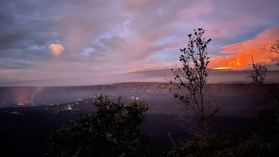
Dozens of earthquakes swarm Hawaii - one of them a magnitude 4.2 - as the world's largest volcano erupts
Live Science - November 29, 2022
Viewers flock to watch glowing lava ooze from Hawaii volcano
PhysOrg - December 1, 2022
Buildings damaged but no tsunami warning for Solomon Islands after 7.0 earthquake Reuters - November 22, 2022
Authorities in the Solomon Islands said no tsunami warning would be issued after two powerful earthquakes struck on Tuesday, damaging Australia's embassy, the airport and shopping malls and triggering power cuts in the capital, Honiara.
Search underway as magnitude-5.6 earthquake leaves over 200 dead in Indonesia CNN - November 21, 2022
Rescuers were digging through debris on Tuesday to find survivors of a powerful earthquake that toppled homes and buildings in a highly populated area of Indonesia�s West Java province, killing at least 268 people. A further 151 people remain missing and more than 1,000 were injured, the country�s National Agency for Disaster Management (BNPB) said.
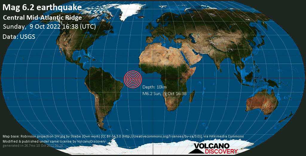
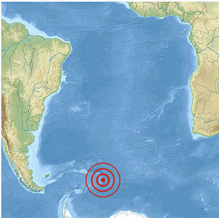
Very strong mag. 6.2 earthquake - South Atlantic Ocean Volcano Discovery - October 10, 2022
Slight shifts in magnetic field preceded California earthquakes PhysOrg - October 8, 2022
Researchers studying intermediate to large earthquakes in California have discovered detectable changes in the local magnetic field that occur 2-3 days before an earthquake.
'Baby' island appears in Pacific Ocean after underwater volcano erupts CNN - September 24, 2022
Powerful 6.2 quake shakes Indonesia, but no casualties reported PhysOrg - September 24, 2022
Quake of magnitude 6.1 hits in Pacific off southern Chile ABC - September 24, 2022
Mexico earthquake triggers 'desert tsunami' 1,500 miles away in Death Valley cave PhysOrg - September 23, 2022
About five minutes after the 7.6 magnitude earthquake hit near Mexico's southwest coast Monday, typically calm water deep in a Death Valley National Park cave started sloshing against the surrounding limestone rock. The reverberations from the earthquake more than 1,500 miles away created what experts have called a "desert tsunami," which on Monday made waves erupt up to 4 feet high in the cave known as Devils Hole, a pool of water about 10 feet wide, 70 feet long and more than 500 feet deep, in Amargosa Valley, Nevada. The water in the partially filled cave has become an "unusual indicator of seismic activity" across the world, with earthquakes across the globe - as far as Japan, Indonesia and Chile - causing the water to splash up Devils Hole, according to the National Park Service website. Interestingly, the 6.8 magnitude earthquake that also hit Mexico's southwest coast early Thursday - not far from Monday's epicenter - did not agitate the water or create any waves in Devils Hole, said Kevin Wilson, National Park Service aquatic ecologist. Thursday's earthquake struck outside Aguililla, a small town in the western state of Michoacan, just after 1 a.m., and caused at least two deaths. Two people also died in Monday's earthquake, the epicenter also in Michoacan, though farther east.
A 7.6-magnitude earthquake off the southwestern coast of Mexico in Michoacan state on Monday has prompted tsunami warnings and caused at least one death CNN - September 19, 2022
Tsunami warnings issued after 6.9-magnitude earthquake hits Taiwan followed by powerful aftershocks CNN - September 18, 2022
September 18: Taiwan - 6.9
September 17: Taiwan - 6.5
September 4: South east of Loyalty Islands - 7.0
Over in the Atlantic
September 4: Central mid Atlantic Ridge - 6.9
Massive 7.6 earthquake rocks Papua New Guinea
PhysOrg - September 11, 2022
Our story ends with the breaking up of the tectonic plates resulting in various natural disasters from tsunamis to earthquakes to volcanic eruptions and more.
A major tsunami in Papua New Guinea was shown to me in 1995 when Crystalinks began and is another end time marker I've posted about on Crystalinks over the past 27 years.
Stronger than a PNG quake and future tsunami is the rise of the Mid-Atlantic Ridge - as well as the shimmering black hole I 'see' below Antarctica.
La Palma Canary Islands Mega-Tsunami Theory.
And then there's the more relatable tsunami dream in which you are drowning.
Rescue teams are scrambling to save those trapped under rubble, but efforts are hampered by heavy rain, and a lack of sufficient infrastructure and resources. Afghanistan's Taliban government has appealed for more international help to cope with the devastating earthquake that's feared to have killed at least 1,000 people.

Magnitude 8 earthquake rattles Peru, killing at least 1 CBS - May 26, 2022
Very strong M7.2 earthquake hits southern Peru Watchers - May 26, 2022
Cusco takes us to the land of the Inca and all those ancient ruins, legends, Viracocha, aliens, my personal favorite the Ica Stones, and more.
Underwater volcano in Antarctica triggers 85,000 earthquakes - the strongest seismic outburst ever recorded in Antarctica Live Science - April 27, 2022

The quakes were likely caused by hot magma poking into the crust, new research finds.
Record-Breaking Earthquake Swarm Hits Antarctica as Sleeping Volcano Awakens Science Alert - April 28, 2022
The swarm occurred around the Orca Seamount, an inactive volcano that rises 2,950 feet (900 meters) from the seafloor in the Bransfield Strait, a narrow passage between the South Shetland Islands and the northwestern tip of Antarctica. In this region, the Phoenix tectonic plate is diving beneath the continental Antarctic plate, creating a network of fault zones, stretching some portions of the crust and opening rifts in other places
Mid-Atlantic island girds for feared quake, volcano eruption PhysOrg - March 24, 2022
Authorities on a Portuguese island in the North Atlantic are preparing for the possible evacuation of local people, as six straight days of minor temblors stoke fears of a possible major earthquake or volcanic eruption. The president of the Azores Islands' regional government said Thursday that airlines are increasing the number of flights into and out of Sao Jorge, where around 8,300 people live, for people who prefer to leave now. Officials in the island municipality of Velas, the epicenter of more than 2,000 minor earthquakes since March 19, are taking elderly people who might have difficulty in quickly evacuating to another part of the island as a precautionary measure.
Strong 6.7 Earthquakes Rock Both the Mid-Atlantic Ridge and the Pacific Near Taiwan; No Tsunami Threat in Atlantic or Pacific Weatherboy - March 22, 2022
Magnitude-7.3 earthquake strikes Fukushima, tsunami warning issued Live Science - March 16, 2022
The quake hit 36 miles (60 kilometers) below the sea at roughly 11.30 p.m. local time on Wednesday (March 16), shaking buildings in Tokyo, knocking people off their feet, and leaving 2 million homes without power. The agency has issued a tsunami warning that waves of up to 3 feet (1 meter) could hit the Miyagi and Fukushima prefectures.
The 'Slow And Silent' Part of The San Andreas Fault May Still Be an Earthquake Threat Science Alert - March 7, 2022
A new study has uncovered signs that the 'slow and silent' section of the famous fault line could indeed have hosted some impressive tremors fairly recently in history.
Earthquake fracture energy relates to how a quake stops PhysOrg - March 7, 2022
By examining earthquake models from a fresh perspective, Cornell engineers now show that the earthquake fracture energy - once thought to relate to how faults in the Earth's crust weaken - is related to how quakes stop
Wild New Paper Suggests Earth's Tectonic Activity Has an Unseen Source Science Alert - January 26, 2022
A newly published study looks to the skies for an explanation. Noting that force rather than heat is most commonly used to move large objects, the authors suggest that the interplay of gravitational forces from the Sun, Moon, and Earth could be responsible for the movement of Earth's tectonic plates.
A 6.2 magnitude earthquake off the coast of Northern California rattled a wide swath of the state CNN - December 20, 2021
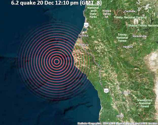 The quake occurred just off Cape Mendocino near Humboldt County and was felt as far away as San Francisco and Chico, California.
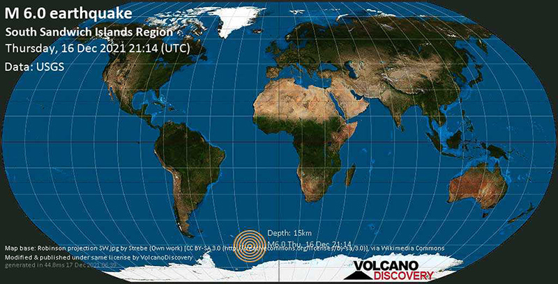
Very strong mag. 6.0 earthquake - South Atlantic Ocean and South Sandwich Islands Volcano Discovery - December 16, 2021
Hidden magnitude-8.2 earthquake was hidden within the magnitude 7.2 earthquake - and the source of mysterious 2021 global tsunami PhysOrg - February 8, 2022
The San Andreas and San Jacinto faults have ruptured simultaneously at least three times in the past 2,000 years, most recently in 1812 PhysOrg - December 14, 2021
New Madrid Seismic Zone
Speaking of 1812 ... The New Madrid fault zone was responsible for the 1811-12 New Madrid earthquakes, and has the potential to produce large earthquakes in the future. Since 1812, frequent smaller earthquakes have been recorded in the area. Earthquakes that occur in the New Madrid Seismic Zone potentially threaten parts of eight American states: Illinois, Indiana, Missouri, Arkansas, Kentucky, Tennessee, Oklahoma, and Mississippi. The zone had four of the largest North American earthquakes in recorded history, with moment magnitudes estimated to be as large as 7.0 or greater, all occurring within a 3-month period between December 1811 and February 1812.
Scientists have detected the deepest earthquake ever, a staggering 467 miles (751 kilometers) below the Earth's surface. That depth puts the quake in the lower mantle, where seismologists expected earthquakes to be impossible Live Science - November 8, 2021
This makes the quake something of a head-scratcher. The vast majority of earthquakes are shallow, originating within the Earth's crust and upper mantle within the first 62 miles (100 km) under the surface. In the crust, which extends down only about 12 miles (20 km) on average, the rocks are cold and brittle. When these rocks undergo stress. They can only bend a little before breaking, releasing energy like a coiled spring.
Quake on Greek island of Crete kills one, spreads panic CNN - September 27, 2021
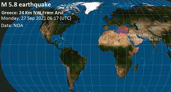
The quake, measuring magnitude 5.8 according to Greece's seismological observatory, killed a man who had been repairing a church.
The seismic zone worrying quake-hit Mexico. A 7.1-magnitude earthquake that struck southern Mexico this week originated near a section of a fault that experts worry has been building up tension for more than a century. PhysOrg - September 9, 2021
A powerful 7.0 earthquake struck the southwest of Mexico late Tuesday, causing widespread shaking as far away as Mexico City killing at least one person CNN - September 8, 2021
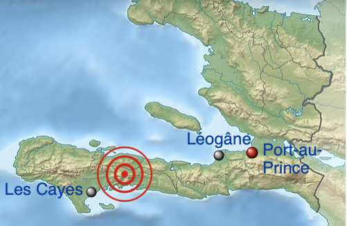
August 2021 7.2 Earthquake in Haiti
At 8:29:09 a.m. EDT on August 14, 2021, a magnitude 7.2 earthquake struck the Tiburon Peninsula in the Caribbean nation of Haiti on the island of Hispaniola. It had a 10-kilometre (6.2 mi; 5.4 nmi)-deep hypocenter near Petit-Trou-de-Nippes, approximately 150 kilometres (93 mi; 81 nmi) west of the capital, Port-au-Prince. It spawned tsunami warnings for the Haitian coast, which were lifted shortly after. The US Geological Survey estimates "high casualties" and widespread disaster; with the dead currently estimated at 724, it is the deadliest earthquake of 2021 so far.
Strong M6.8 earthquake hits near the coast of Vanuatu, hazardous tsunami waves possible Watchers - August 18, 2021
Strong aftershocks continue after M8.1 earthquake hits South Sandwich Islands region Watchers - August 17, 2021
2021 South Sandwich Islands earthquakes Wikipedia
The South Sandwich Islands are approximately 1,733 miles from Antarctica.
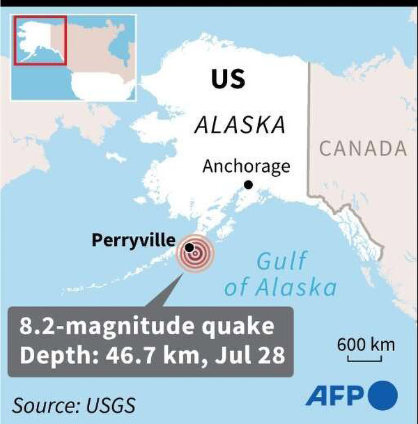
July 28, 2021 Chignik earthquake Wikipedia
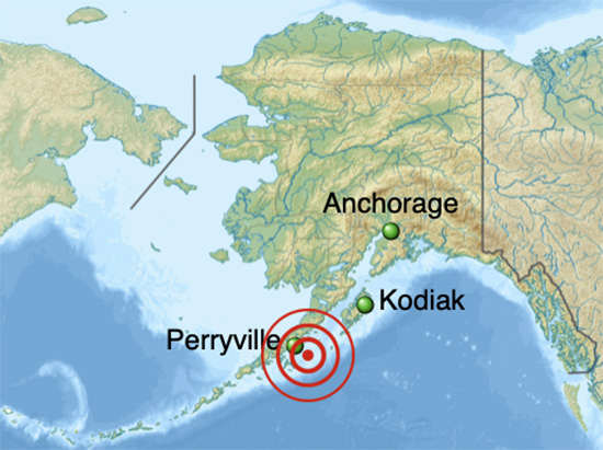
An 8.2 earthquake occurred off the coast of the Alaska Peninsula on July 28, 2021, at 10:15 p.m. local time. The large megathrust earthquake had a moment magnitude (Mw) of 8.2 according to the United States Geological Survey (USGS). A tsunami warning was issued by the National Oceanic and Atmospheric Administration (NOAA) but later cancelled. The main shock was followed by a number of aftershocks, including three that were of magnitude 5.9, 6.1 and 6.9 respectively. This was the largest earthquake in the United States since the 1965 Rat Islands earthquake, and the 7th largest earthquake in US history. It was also the strongest earthquake in the world since the 2018 Fiji earthquake.
The landmass beneath the Pacific Ocean is one of a few dozen tectonic plates that make up the earth's crust. Each year, the Pacific Plate pushes a couple of inches towards Alaska, which is generally considered to be part of the North American Plate.
Alaskan coast 8.2 magnitude earthquake was the strongest one in decades - No Tsunami CNN - July 29, 2021
Strong undersea quake shakes Indonesia; no tsunami warning PhysOrg - July 29, 2021
The New Moon 18 Cancer on July 10, 2021 created lots of earthquakes - including a 6.0 at the California-Nevada Border not far from where I was "taken" on a UFO in 1954 as my story unfolded in this reality and continues until the end. The night before I told my Facebook friend, Eugene, that it was time for another earthquake. It manifested exactly 24 hours later EDT.
U.S. Navy sets off giant explosion to test USS Gerald R. Ford aircraft carrier. The blast registered as a 3.9 magnitude earthquake. CBS - June 21, 2021
The U.S. Navy has started a series of tests on its newest and most advanced aircraft carrier by detonating powerful explosions to determine whether the ship is ready for war. The first of the tests, which are known as Full Ship Shock Trials, occurred Friday when the Navy set off a giant explosive event near the USS Gerald R. Ford, according to a statement.
Major Earthquake Fault Study Reveals How Earth Controls The Magnitude of Ruptures Science Alert - April 21, 2021
Earthquake gates around the world are under investigation, but the 4,000 years of sediment data and 100,000 years of AI-generated simulations at New Zealand's Alpine Fault give geologists a particularly large pool of data to study.
New Zealand Earthquakes and Aftershocks
The 2021 Kermadec Islands 8.1 earthquake occurred on March 4, 2021. The epicenter was located south of Raoul Island in the Kermadec Islands. The earthquake was preceded by a magnitude 7.4 foreshock and followed by a magnitude 6.1 aftershock. A separate, unrelated magnitude 7.3 earthquake occurred off the coast of North Island, approximately 900 km to the south, several hours before the main quakes.
Friday: New Zealand downgrades tsunami warning after 8.1-magnitude earthquake CNN - March 5, 2021
Video: Tsunami Warning Lifted After Major 7.4 Earthquake Causes Severe Shaking in New Zealand Weather.com - March 4, 2021
Powerful earthquakes, including M8.1, M7.4 and M6.1 hit the Kermadec Islands - Tsunami warnings issued Watchers - March 4, 2021
Greece: Major magnitude 6.2 earthquake strikes Volcano Alert - March 4, 2021
Unusual earthquakes highlight central Utah volcanoes PhysOrg - March 3, 2021
If you drive south through central Utah on Interstate 15 and look west somewhere around Fillmore, you'll see smooth hills and fields of black rock. The area is, aptly, named the Black Rock Desert. It may not look like much, but you're looking at some of Utah's volcanoes. A pair of earthquake sequences, in September 2018 and April 2019, focused scientists' attention on the Black Rock Desert. The sequences, which included the main quakes and their aftershocks, were very different from the Magna earthquake that shook the Wasatch Front in 2020 and other Utah earthquakes. The Black Rock sequences were captured by the Utah Regional Seismic Network and by nearby temporary seismic equipment deployment that was monitoring a geothermal well. Earthquakes in the Black Rock Desert are rare and capturing the seismic recordings from these earthquakes provides a glimpse into the volcanic system of the Black Rock Desert that, while not showing any signs of erupting, is still active. A study of the earthquake sequences is published in Geophysical Research Letters.
Strange Earthquakes in Utah Reveal Volcanic Activity Hidden Below The Desert Science Alert - March 3, 2021
It might not look like it, but the arid expanses of Utah conceal an ancient volcanic complex, and this hidden underground system is still active far below the desert's surface, scientists say.
Antarctica rocked by 30,000 tremors in 3 months, Chilean scientists say Reuters - December 16, 2020
More than 30,000 tremors have rocked Antarctica since the end of August, according to the University of Chile, a spike in seismic activity that has intrigued researchers who study the remote, snowbound continent. Scientists with the university's National Seismological Center said the small quakes - including one stronger shake of magnitude 6- were detected in the Bransfield Strait, a 60-mile wide (96-km) ocean channel between the South Shetland Islands and the Antarctic Peninsula. Several tectonic plates and microplates meet near the strait, leading to frequent rumbling, but the past three months have been unusual, according to the center.
Minor 3.6 quake shakes RI, Massachusetts - earthquakes happen on a regular basis in New England, but this was the strongest to strike the region in decades NBC - November 8, 2020
Earthquake felt in Massachusetts, Rhode Island Sunday morning - no immediate reports of damage PhysOrg - November 8, 2020
4.0 magnitude earthquake strikes near Bliss Corner, Massachusetts, USGS says CNN - November 8, 2020
Watch: Moment Tsunami Flows Through Turkey Town After Earthquake Weather.com - November 3, 2020
Videos: A powerful earthquake has struck off Turkey's Aegean coast and north of the Greek island of Samos, destroying homes and killing at least 22 people. BBC - October 31, 2020
An earthquake off the coast of Turkey killed at least 62 people and injured more than 900. Rescuers continued to dig through tons of rubble for survivors Izmir, the country�s third largest city.
Powerful 7.0 earthquake jolts Turkey and Greece, killing at least 27 CNN - October 31, 2020
The earthquake sent buildings crashing down and triggering what authorities have called a "mini tsunami."
Fault near Portland could unleash a major earthquake Live Science - October 23, 2020
A fault near Portland, Oregon, has the capacity to cause strong shaking in the region - and has done so as recently as 1,000 years ago.
New research into the Gales Creek fault, which lies 22 miles (35 kilometers) west of Portland, reveals that earthquakes on the fault have ruptured the surface three times in the last 9,000 years. Today, the fault is capable of producing an earthquake of up to magnitude 7.1 to 7.4, which would create very strong shaking and damage property and potentially threaten lives in the Portland metro region.
Small tsunami generated by magnitude 7.5 earthquake that prompted evacuation orders CNN - October 19, 2020
Langley said the tsunami sent two waves, each measuring 130 centimeters (4 feet, 3 inches) high. But observers onshore reported the waves appeared to be 1.5 feet (45.7 centimeters) and 2 feet (61 cm) over high tide. The center is monitoring harbors in a 500-mile area along the Alaska coastline, he said.
Ice Melt in Alaska Threatens to Unleash Unprecedented 'Mega-Tsunami', Scientists Warn Science Alert - October 19, 2020
A giant, catastrophic tsunami in Alaska triggered by a landslide of rock left unstable after glacier melting is likely to occur in the next two decades, scientists fear - and it could happen within the next 12 months.
What wobbling rocks can tell us about nuclear safety BBC - October 1, 2020
We've all seen them; we've even taken pictures of ourselves pretending to hold them up or to push them over. These are the precariously balanced rocks on a hill or a coastal cliff. It's as if the gentlest nudge would send them tumbling. In truth, the disturbance needed to unsettle the blocks is quite significant, and that got husband and wife geologists Drs Dylan and Anna Rood wondering about how these great stones could be used to decipher earthquake history. Think about it: if a precariously balanced rock has held its position for 10,000 years without tipping over, it means the land around the stone hasn't experienced shaking above a certain level in all that time.
The mysterious luminescence phenomena of earthquake lightning PhysOrg - September 28, 2020
Were you aware that earthquakes are sometimes associated with luminescence, called earthquake lightning? This phenomenon had been documented throughout history, such as between 1965 and 1967, the Matsushiro earthquake swarm caused the surrounding mountain to flicker with light multiple times. In 1993 when an earthquake caused a tsunami off the coast in Southwest Hokkaido which caused 5 boats resting at shore to instantly ignite and burn. Various models have been proposed to explain earthquake lightnings, and it seems as though various factors contribute to such light emissions.
Strong mag. 6.6 earthquake - Central Mid Atlantic Ridge
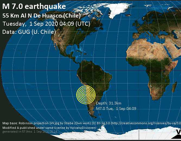
Major mag. 7.0 earthquake - Chile Volcano Discovery - September 1, 2020
Rare 'boomerang' earthquake observed along Atlantic Ocean fault line PhysOrg - August 10, 2020
Scientists have tracked a 'boomerang' earthquake in the ocean for the first time, providing clues about how they could cause devastation on land. While large (magnitude 7 or higher) earthquakes occur on land and have been measured by nearby networks of monitors (seismometers), these earthquakes often trigger movement along complex networks of faults, like a series of dominoes. This makes it difficult to track the underlying mechanisms of how this 'seismic slip' occurs. Under the ocean, many types of fault have simple shapes, so provide the possibility get under the bonnet of the 'earthquake engine'. However, they are far from large networks of seismometers on land. The team made use of a new network of underwater seismometers to monitor the Romanche fracture zone, a fault line stretching 900km under the Atlantic near the equator.
Wednesday: Preliminary magnitude 7.8 earthquake strikes off coast of Alaska - 11 aftershocks CNN - July 22, 2020
Powerful quake jolts Alaska towns, produces small tsunami PhysOrg - July 22, 2020
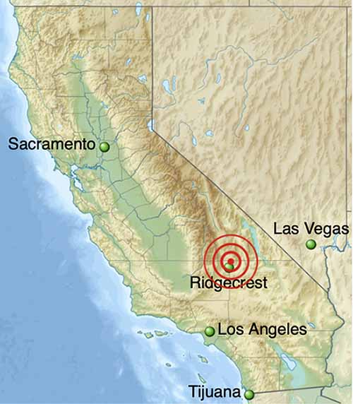
California's chances of experiencing the Big One on the San Andreas fault in the next 12 months have tripled after recent spate of micro-quakes Daily Mail - July 14, 2020
More than 3,000 earthquakes rocked Ridgecrest, California in a single week last year and as a result, has increased chances of the 'Big One' striking the San Andreas fault. The tremors stressed the Garlock Fault, which stretches 160 miles along the Mojave Desert and connects the site of the Ridgecrest quakes to the massive San Andreas fault. Garlock was previously estimated to have a 0.023 percent chance of experiencing a quake of magnitude 7.5 or great in the next 12 months, but now following 2019 that risk has increased to 2.3 percent.
Chance of big San Andreas earthquake increased by Ridgecrest temblors, study suggests PhysOrg - July 13, 2020
A new study suggests that last year's Ridgecrest earthquakes increased the chance of a large earthquake on California's San Andreas fault. The chance of a large quake on the San Andreas has roughly tripled, from 0.35% in the next year to 1.15%, said Ross Stein, a co-author of the study and the CEO of Temblor, a catastrophe modeling company in the Bay Area that has built a free earthquake hazards app for smartphones.
Boise shakes again with a 4.6 - one of the strongest aftershocks of the March earthquake a 6.5 Idaho Statesman - June 25, 2020
A strong aftershock shook Boise around 11:20 p.m. Wednesday - continuing what has been a string of earthquakes since the March 31 main event. Wednesday�s quake registered as a 4.6 magnitude, according to the U.S. Geological Survey. That would make it the second-strongest aftershock recorded so far. The March 31 earthquake was a 6.5 magnitude, the second-strongest in Idaho history. It was centered in the mountains 19 miles northwest of Stanley.
This California Earthquake Swarm Lasted 4 Years. We May Finally Know Why Science Alert - June 24, 2020
Water deep below the surface of the Earth can trigger quakes and tsunamis by lowering the melting point of rocks along fault lines, study shows Daily Mail - June 24, 2020
Water deep below the surface of the Earth triggers earthquakes and tsunamis by lowering the melting point of rocks along fault lines, a new study reveals. UK scientists say they've found a correlation between water release data and levels of seismic activity along the Caribbean-American tectonic plate border. This process occurs in subduction zones, where the Earth's tectonic plates converge and one plate sinks beneath another.
5.8 magnitude earthquake shakes California - The epicenter was near Cartoga, about 180 miles north of Los Angeles ABC - June 24, 2020
People at several businesses near Lone Pine and Bishop told ABC News the while the shaking was "intense," they didn't see any damage.
Several rockslides were reported in Inyo County. This comes a day after a 7.4 magnitude quake hit Mexico, near the resort of Huatulco, killing at least six people and damaging hundreds of homes, according to The Associated Press. At least six others were hurt, including two people in Mexico City, more than 300 miles from the epicenter.
7.4 magnitude earthquake hit southern Mexico CNN - June 23, 2020
At least two people have died after a 7.4 magnitude earthquake hit Mexico's southern coastline on Tuesday, collapsing buildings and prompting evacuations. The earthquake occurred at 10:29 a.m. local time (11:29 a.m. ET), with an epicenter 6.8 miles southwest of Santa Mar�a Zapotitl�n in Oaxaca state, near El Coyul. Oaxaca's state governor Alejandro Murat said a 22-year-old woman and a man were among the dead. The Oaxacan Health Services also reported damages from the quake to general hospitals in Pochutla, Puerto Escondido and Pinotepa Nacional and a few community hospitals in other areas. According to Murat, two of the hospitals with damages have been dealing with coronavirus patients.
Giant tectonic plate under Indian Ocean is breaking in two Live Science - May 22, 2020
In a short time (geologically speaking) this plate will split in two, a new study finds.
The African continent is very slowly peeling apart. Scientists say a new ocean is being born NBC - July 19, 2020
In one of the hottest places on Earth, along an arid stretch of East Africa�s Afar region, it�s possible to stand on the exact spot where, deep underground, the continent is splitting apart. This desolate expanse sits atop the juncture of three tectonic plates that are very slowly peeling away from each other, a complex geological process that scientists say will eventually cleave Africa in two and create a new ocean basin millions of years from now. For now, the most obvious evidence is a 35-mile-long crack in the Ethiopian desert.
Video: 6.1-magnitude earthquake strikes in ocean west of Mexico FOX News - May 22, 2020
Strong mag. 6.1 earthquake - Off Coast of Central Mexico on Friday, 22 May 2020 Volcano Discovery- May 22, 2020
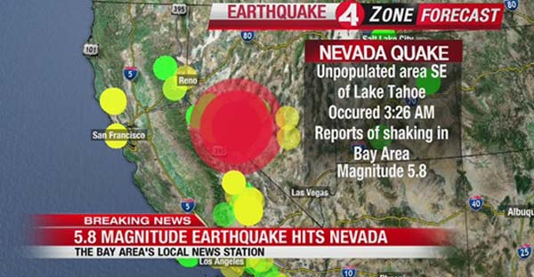
The U.S. Geological Survey is reporting a magnitude-6.5 earthquake struck western Nevada near Mina and Tonopah early Friday. The quake had a first reported magnitude of 6.4, which had been downgraded to a magnitude-5.8, but has since been upgraded back to 6.5. The temblor was reported at 4:03 a.m. about 35 miles outside Tonopah, just east of the Sierra Nevada range, southeast of Lake Tahoe. The quake's depth was estimated to be 4.7 miles (7.6 kms) deep. Thousands of people across California including areas across the Bay Area, Sacramento, and the Central Valley reported feeling the earthquake.
Magnitude-6.5 earthquake is largest in Nevada in past 66 years CNN - May 15, 2020
Magnitude-6.5 earthquake in Nevada has a long history of temblors Live Science - May 15, 2020
How the Earth's last supercontinent broke apart to form the world we have today BBC - May 14, 2020
Pangaea was the Earth's latest supercontinent�a vast amalgamation of all the major landmasses. Before Pangaea began to disintegrate, what we know today as Nova Scotia was attached to what seems like an unlikely neighbor: Morocco. Newfoundland was attached to Ireland and Portugal.
5.7 magnitude earthquake in Utah knocks out power to thousands and diverts flights CNN - March 18, 2020
A 5.7 magnitude earthquake shook the Salt Lake City area Wednesday morning, cutting power to tens of thousands and suspending work at Utah's public health lab amid the coronavirus pandemic, officials said. The quake was centered about 10 miles west of Salt Lake City, near the city of Magna.
5.7 magnitude earthquake hits Utah; power outages reported in Salt Lake City USA Today - March 18, 2020
People in Colorado, Idaho, Wyoming and Nevada reported feeling the quake. In downtown Salt Lake City, The Church of Jesus Christ of Latter-day Saints' iconic Salt Lake Temple sustained minor damage. It was the largest earthquake in Utah since a 5.9 magnitude quake hit the state in 1992, Utah Emergency Management said.
Magnitude 5.2 earthquake shakes northern California coast Mercury News - March 18, 2020
A 5.2 magnitude earthquake rattled the northern California coast Wednesday afternoon, centered not far from the origin of a larger quake that occurred March 8, according to the U.S. Geological Survey. Wednesday�s temblor just after 3 p.m. had its epicenter under the Pacific Ocean about 35 miles southwest of Eureka and fewer than 10 miles offshore, federal agencies reported. Nearly 100 Eureka residents submitted online reports by 4:15 p.m. to the Geological Survey saying they�d felt shaking.
2020 Caribbean earthquake Wikipedia
Caribbean earthquake of 7.7 triggers tsunami warnings BBC - January 28, 2020
Magnitude 7.7 earthquake strikes off the coast of Jamaica and is felt as far away as Miami CNN - January 28, 2020
Why are there so many earthquakes in the Caribbean? Two tectonic plates go to war PhysOrg - January 29, 2020
2020 Puerto Rico earthquakes Wikipedia
6.4-quake strikes Puerto Rico, killing at least 1 amid heavy seismic activity NBC - January 8, 2020
A 6.4-magnitude earthquake struck Puerto Rico early Tuesday, killing at least one person and causing a power outage across the island, as well as structural damage to roads and bridges especially in the southwestern region. There have been at least 35 aftershocks since the earthquake, the largest in a series of quakes, hit at 4:24 a.m. Federal agencies monitoring the seismic activity say the tremors and quakes could continue for the next few days, according to Gov. Wanda Vazquez. At a press conference Tuesday morning, Vazquez announced the island is in an official state of emergency.
Puerto Rico's Iconic Arecibo Observatory Closed by Major Earthquake Space.com - January 8, 2020
Earthquake impact can be affected by seasonal factors, historical study shows PhysOrg - November 6, 2019
The season that an earthquake occurs could affect the extent of ground failure and destruction that the event brings, according to a new look at two historical earthquakes that occurred about 100 years ago near Almaty, Kazakhstan.
Distinguishing earthquake foreshocks and aftershocks PhysOrg - October 10, 2019
Up to now, there was no way of predicting whether a powerful earthquake was likely to be followed by one of even greater magnitude. But the results of a study awaken hopes that we will soon be able to do just that, in real time.
Historic earthquakes suggest Trans-Mexican Volcanic Belt's quiet regions are active PhysOrg - October 9, 2019
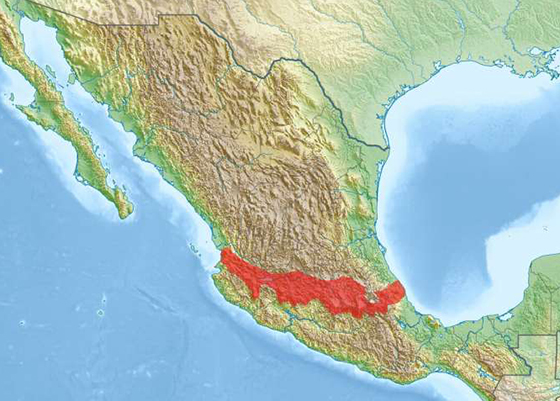
Seemingly low-hazard seismic regions in Mexico have experienced multiple, strong earthquakes since the 1500s, new research finds, suggesting the regions have many unmapped, active fault lines. The areas are inside the Trans-Mexican Volcanic Belt, home to roughly 40 percent of Mexico's population, who may be unaware of the land's seismic history. New research collected archival records documenting the belt's historic earthquakes, converting the historic reports into numerical data. The new study in the AGU Journal Tectonics found there have been at least 16 large earthquakes during the past 450 years in areas of the belt previously believed to be dormant, challenging an existing understanding of the belt's behavior.
I have been watching the Mid-Atlantic Ridge - which is rising like mythological Atlantis - since I started Crystalinks in 1995. On November 30, 2017 it created a 4.1 earthquake in Dover, Delaware that I felt here in south Brooklyn.
The Atlantic Plate now seems to be communicating with the Pacific Plate where 3 quakes hit off the coast of Oregon today. Read on ..
3 Earthquakes strike off Oregon coast 9KEZI - September 5, 2019
5.9-magnitude quake hits Northern Mid-Atlantic Ridge: USGS Trend News Agency - September 5, 2019
Most of California's Big Earthquakes Are Preceded by Ghostly 'Foreshocks' Weeks in Advance Live Science - August 26, 2019
How do earthquakes begin? It's an ancient question - and while scientists have ruled out the vengeful gods blamed over the past few millennia, agreeing that tremors are more a matter of grinding plate tectonics than of Poseidon's wrath, many facets of this seismic puzzle remain murky. One ongoing mystery is the phenomenon of foreshocks, small, sometimes imperceptible tremors that can precede larger quakes in the same area by several days or weeks. Studies have found that anywhere from 10% to 50% of large earthquakes follow these mini-shocks. This has led many researchers to wonder whether foreshocks are a geophysical fluke or a standard feature of big quakes that modern instruments just aren't sensitive enough to detect with certainty.
Earthquakes, hurricanes and other natural disasters obey same mathematical pattern
Tracking the magnitude of several catastrophic natural events and drawing a graphic of how many episodes of each have occurred throughout history yields a result which cannot be ignored. Quite on the contrary, what the graphic reveals is a highly defined curve which luckily shows that the stronger the capacity to devastate, the less frequently the episode occurs. For example, very few earthquakes are devastating, but small earthquakes occur frequently, most of them so weak that people do not perceive them and they are only detected by highly sensitive sensors. This information is essential when calculating any associated risks.
Ridgecrest California Earthquakes - July 4, 2019 (6.4) and July 6, 2019 (7.1)
An Even Larger 7.1 Quake Just Rocked Southern California. Experts Say the Fault System Is Growing. Live Science - July 6, 2019
July 4th earthquake won't delay the Big One. And it might have worsened quake strain PhysOrg - July 6, 2019
What Will Really Happen When San Andreas Unleashes the Big One? Smithsonian - July 6, 2019
Peru 8.0 earthquake leaves one dead and several injured CNN - May 27 2019
One person was killed and at least 11 people have been injured in Peru, with a further seven injuries in neighboring Ecuador, after an 8.0 magnitude earthquake struck northern Peru on Sunday morning. Peru's National Emergency Operations Center reported the death of a 48-year-old man from the Cajamarca region in northwestern Peru following an earthquake in the country's Amazon region. The earthquake's epicenter was at an approximate depth of 115 km, according to preliminary readings from the United States Geological Survey, and it was felt as far afield as Lima, Peru; Caracas, Venezuela; and Quito, Ecuador. Ricardo Seijas, head of the emergency operations center, said the number of injured had risen to at least 11 people. The emergency operations center reported numerous damages to buildings including five schools; two religious temples; and four health centers. Two additional health centers collapsed, said Seijas.
7.2 magnitude earthquake strikes Papua-New Guinea NBC - May 6, 2019
Tiny Earthquakes Shake Southern California Every 3 Minutes Live Science - April 18, 2019
Southern California is a lot shakier than ever before realized. According to a new study, a tiny earthquake rumbles through the southern portion of the Golden State every 3 minutes. These temblors won't knock down walls or send palm trees swaying. In fact, they're too small for even typical seismic instruments to regularly detect. But their discovery reveals seismic activity that scientists couldn't previously detect. Understanding the full pattern of activity should help seismologists understand how larger earthquakes get started and how quakes can trigger one another.
7.1-magnitude earthquake hits southern Peru FOX - March 1, 2019
The temblor's epicenter was 16 miles north-northeast of Azangaro and it had a depth of around 160 miles. The earthquake struck at 3:50 a.m.
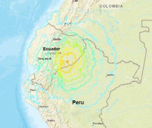
7.5 Magnitude Earthquake Strikes Near Ecuador's Border With Peru NPR - February 22, 2019
California's deadly 'Big One' could be caused by volcanic eruptions: Report warns the state's seven active volcanoes are a nearly forgotten hazard despite events occurring as often as major San Andreas quakes Daily Mail - February 26, 2019
Californians are all, by now, well aware of the risks posed by the state's more hostile natural forces; from earthquakes to wildfires and landslides, officials have spent decades preparing the public for possible disasters. But, experts say there's one major threat they've largely been sleeping on: volcanoes.
Findings shed new light on a phenomenon called 'silent slip,' in which parts of the Earth's crust are displaced along a fault line, but without any seismic activity Oregon Live - January 29, 2019
Researchers at Oregon State University have found a new explanation as to why foreshocks often precede large earthquakes. Large quakes appear to follow a short period of 'shallow mantle creep' and 'seismic swarms,' . The findings shed new light on a phenomenon called 'silent slip,' in which parts of the Earth's crust are displaced along a fault line, but without any seismic activity.
Beware the New Madrid Fault Zone
2 earthquakes shake Southeastern US CNN - December 12, 2018
Two earthquakes struck Wednesday morning in eastern Tennessee, rattling people awake across several Southeastern states.
The first one, a preliminary 4.4-magnitude earthquake, occurred at 4:14 a.m. local time. It was the second strongest quake on record in east Tennessee, the local National Weather Service office tweeted, citing USGS. A preliminary 3.3-magnitude quake took place shortly after at 4:27 a.m. local time.
November 30, 2018
I spend the morning on the day of the devastating 7.0 Anchorage Earthquake cleaning up my files on Earth Changes because I felt something big on the horizon. And then this happened at a time the nights in Alaska grow longer as the cold darkness of winter sets in. With aftershocks and power outages I hope people are prepared.
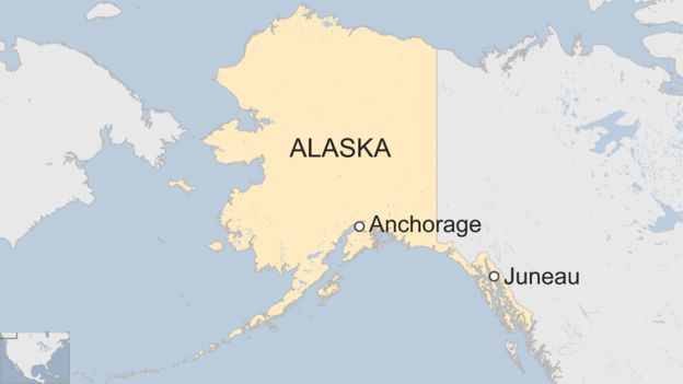
2018 Anchorage Earthquake Wikipedia
Alaska earthquake: A 7.0 magnitude earthquake just struck outside of Anchorage, Alaska. CNN - November 30, 2018
Alaska earthquake: Anchorage rocked by major earthquake BBC - November 30, 2018
A major 7.0 magnitude earthquake has struck Alaska, causing people to run from buildings and briefly prompting a tsunami alert for coastal areas. The quake was centered about seven miles (11km) north of Anchorage, the largest city in the state, according to the US Geological Survey (USGS). A series of aftershocks was recorded following the initial shock, which had a depth of 40.9km, the USGS said. Around 300,000 people live in Anchorage with 100,000 in the surrounding area.
Punctuated earthquakes for New Madrid area: New research uncovers cluster of past events PhysOrg - November 6, 2018
In 1811 and 1812, the region around New Madrid, Missouri, experienced a number of major earthquakes. The final and largest earthquake in this sequence occurred on the Reelfoot fault, and temporarily changed the course of the Mississippi River. These earthquakes are estimated to be just shy of magnitude 8.0 and devastated towns along the Mississippi River - soil liquefied, houses collapsed, and chimneys toppled. Because of the 1811-1812 earthquakes, the New Madrid area is recognized as a high-hazard zone for potential future seismic events. Previous investigations found have also found evidence for multiple, older earthquake events preserved in the geologic record.
Daily Mail - October 13, 2018
Revealed: How an earthquake 11,109km away in CHILE could trigger a tsunami big enough to strike Sydney - as experts warn it's only a matter of time until it happens. Tsunami waves from a 1960 Chilean earthquake were recorded in Sydney. A coastal science expert has warned there is always 'potential' for a large event. The likely size of tsunami waves in Sydney remains between 0.2 - 1 metres.
Previous 60m high tsunamis have hit east coast and reached up to 50km inland. Experts have explained the Australian tsunami detection system in a video.
Magnitude-6.8 earthquake damages harbor, 15th-century monastery on Greek island ABC - October 27, 2018
A powerful earthquake has hit western Greece, damaging a port and a 15th-century monastery, but causing no major injuries, officials and local media said. The Greek island of Zakynthos was all but destroyed during an earthquake in 1953 Power on the island was briefly disrupted Authorities initially issued a tsunami warning following the earthquake The quake struck early on Friday morning, sending out tremors felt as far afield as Libya, Italy, Malta and Albania. Greek authorities initially issued a tsunami warning but later withdrew the alert.
The magnitude 6.4 quake struck in the Ionian Sea, 50 kilometres south of the island of Zakynthos, Greece's Geodynamic Institute reported.
The US Geological Survey rated the magnitude at 6.8. Three people were taken to hospital on the island, two of them slightly injured.
A series of aftershocks, the highest at 5.6, rattled the island and power was briefly disrupted. Tremors damaged a 15th-century monastery on the nearby islands of Strofades, local media in Zakynthos reported. They also left large cracks in the port of Zakynthos, though authorities there said operations would continue as usual.
While the Atlantic area is focusing on Storm Michael and
the aftermath of the October 6, 2018 Earthquake in Haiti
Look what's happening in the Pacific Ring of Fire - Highlighting PNG.
Strong 7.0 quakes strike Papua New Guinea, Bali CBS - October 11, 2018
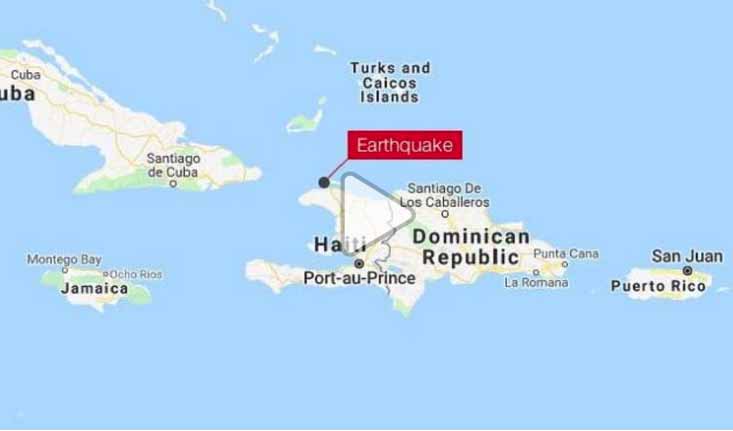
Powerful 5.9 earthquake hits northern Haiti - 12 killed - hundreds wounded
5.3 earthquake hits Mid Atlantic Ridge - October 7, 2018


Feds send first emergency message test to cell phones CNN - October 4, 2018
If you have a cell phone, it probably buzzed and beeped loudly Wednesday afternoon October 3, 2018 around 2:18 p.m. ET. "Presidential Alert," the screen said. "THIS IS A TEST of the National Wireless Emergency Alert System. No action is needed." It' was the first nationwide test of the system built by the federal government and cell phone carriers to warn Americans of an emergency, like a terror attack or a widespread disaster.
-
Did your cell phone go off? Mine did as I was talking to a friend in Florida. Her alert was about one minute behind mine. Some people got nothing. I also had a message on my TV. Many people are worried about this being a warning of things to come - be that an enemy attack or a natural disaster. One should always be prepared for anything in End Times.
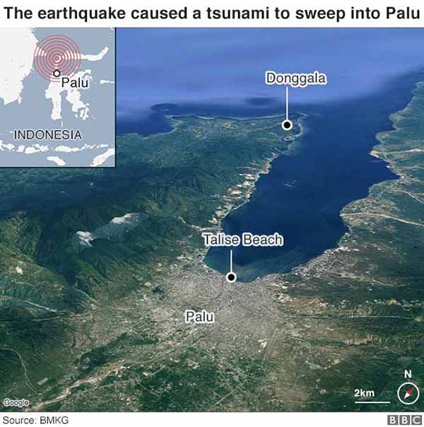
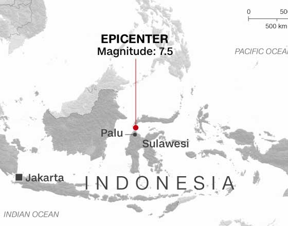
September 28, 2018 Sulawesi Earthquake and Tsunami Wikipedia
Volcano erupts on Indonesia's quake and tsunami-hit Sulawesi NBC - October 3, 2018
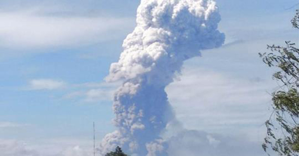
Volcanic activity had been increasing at Mount Soputan since August and began surging Monday, three days after the twin disasters.
Indonesia tsunami: Death toll rises to over 1,200 BBC - October 2, 2018
Indonesia tsunami: Moment quake turns ground into liquid BBC - October 2, 2018
Indonesia tsunami: Aerial shots of debris and survival BBC - October 2, 2018
Why Sulawesi's tsunami is puzzling scientists BBC - October 2, 2018
Geoscientists find unexpected 'deep creep' near San Andreas, San Jacinto faults PhysOrg - September 18, 2018
A new analysis of thousands of very small earthquakes that have occurred in the San Bernardino basin near the San Andreas and San Jacinto faults suggests that the unusual deformation of some�they move in a different way than expected�may be due to "deep creep" 10 km below the Earth's surface.
Major mag. 7.8 earthquake - Fiji Islands on Thursday, 6 September 2018 - information Volcano Discovery - September 6, 2018
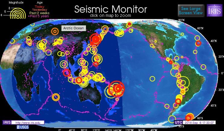
It was an aftershock of the 8.2 quake on August 19.
September 6, 2018 Hokkaido Eastern Iburi earthquake Wikipedia
An earthquake measuring 6.6 MW on the moment magnitude scale struck Iburi Subprefecture in southern Hokkaido, Japan, on 6 September 2018 at 3:08 a.m. Japan Standard Time. The earthquake's epicenter was near Tomakomai and occurred at a depth of 33.4 kilometres (20.8 mi). The Japan Meteorological Agency (JMA) registered a magnitude of 6.7 Mj and a maximum intensity of 7 on the shindo scale. Shaking from the earthquake was felt strongly in Hokkaido and Aomori Prefecture. The earthquake disrupted electrical service throughout Hokkaido, leaving 5.3 million residents without power. Reports state that seventeen people died, 366 people were injured, and 21 remain missing as a result of the quake.
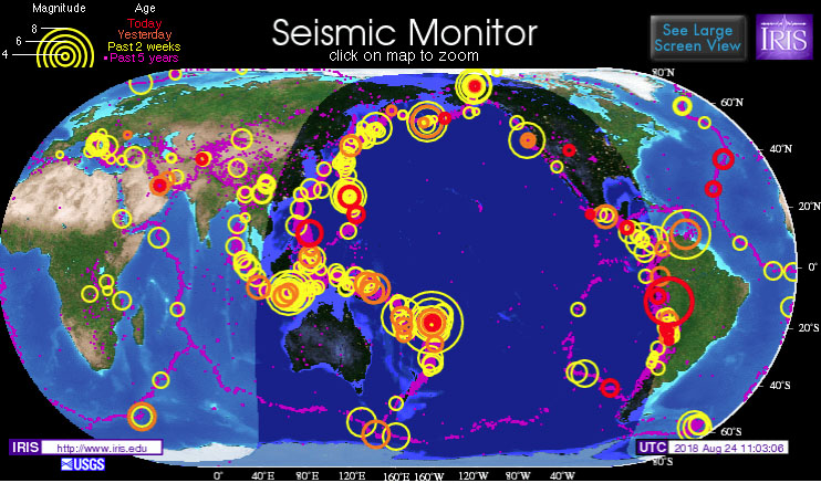
7.1-magnitude earthquake on border of Peru, Brazil, Bolivia USGS reports FOX - August 24, 2018
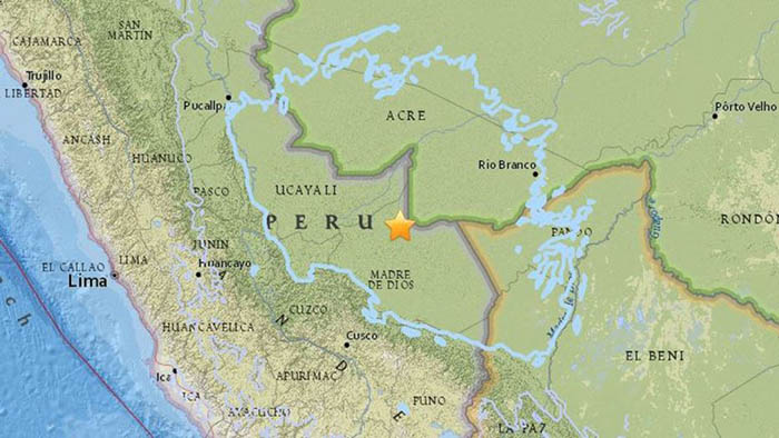
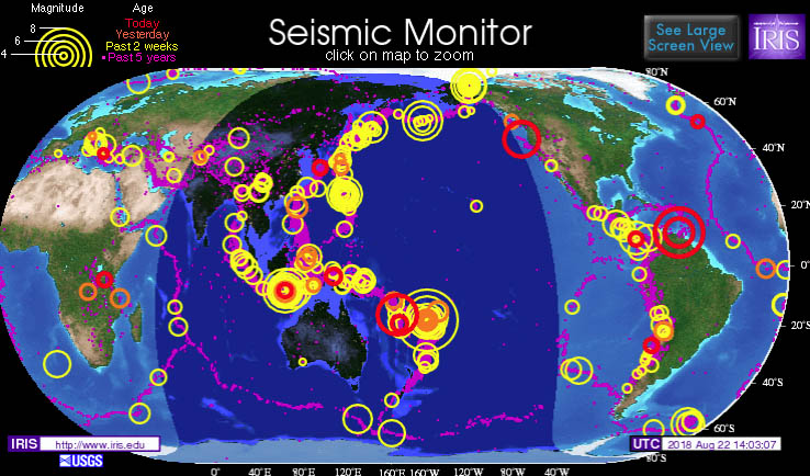
Magnitude 7.3 earthquake shakes the northern coast of Venezuela, no tsunami threat Accuweather - August 22, 2018
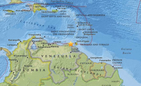
'Big One' talk swirls as 69 massive earthquakes hit the Pacific's Ring of Fire in 48 hours FOX - August 22, 2018
6.2 Earthquake and aftershock rattle Oregon coast CBS - August 22, 2018
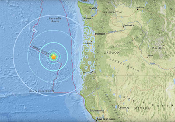
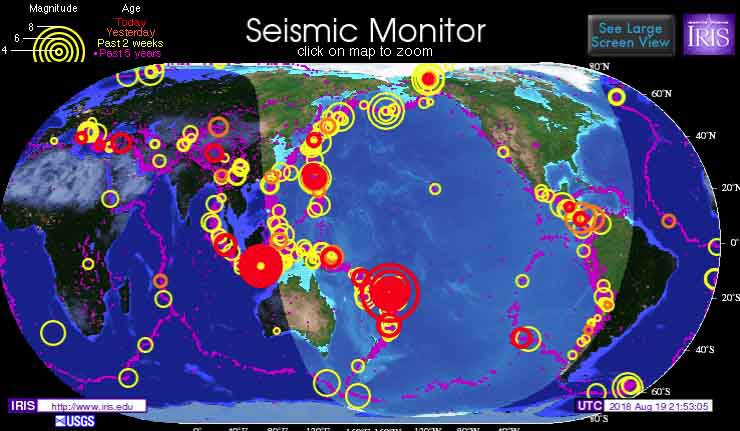
3 major earthquakes strike near Fiji, Tonga and Indonesia CNN - August 19, 2018
8.2 earthquake - Fiji Islands Region on Sunday Discovery - August 19, 2018
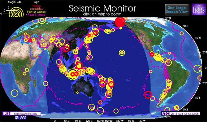
Strongest-ever earthquake strikes Alaska's North Slope region CBS - August 12, 2018
Is London about to be hit by a major Earthquake? Scientists discover two fault lines under the capital that could trigger a massive tremor Daily Mail - June 2, 2018
Scientists have found two fault lines running under London that could cause a magnitude 5 earthquake. The faults move between 1mm and 2mm a year, with one running directly under central London and another under Canary Wharf. While London is believed to be overdue a quake, researchers claim there is only a one-in-a-thousand-year chance of a magnitude 5 tremor occurring in the capital. The last large earthquake to affect London occurred on the 6 April 1580 and was estimated to have been a relatively large magnitude 5.5.
Kilauea: Earthquakes follow eruptions from Hawaii volcano BBC - May 5, 2018
A number of strong earthquakes have hit Hawaii's Big Island, a day after the eruption of the Kilauea volcano. One quake, a 6.9 magnitude south-east of the volcano, was the most powerful to hit the US state since 1975. It briefly cut power, and sent people fleeing from buildings but there was no tsunami warning. Meanwhile there were several fresh eruptions sending up fountains of lava 30m (100ft), destroying several homes and leaving fissures on three streets. The Civil Defense Agency told any remaining residents to evacuate. It said there were deadly levels of dangerous sulphur dioxide gas in the air and emergency crews would not be able to help anyone affected. The new volcanic activity in Mt Kilauea's lower east rift zone amounted to "vigorous lava spattering", the US Geological Survey (USGS) said, adding that additional outbreaks in the area were likely.
Nasa's InSight mission will target 'Marsquakes' BBC - May 5, 2018
The American space agency Nasa has launched its latest mission to Mars. InSight will be the first probe to focus its investigations predominantly on the interior of the Red Planet. The lander - due to touch down in November - will put seismometers on the surface to feel for "Marsquakes". These tremors should reveal how the underground rock is layered - data that can be compared with Earth to shed further light on the formation of the planets 4.6 billion years ago.
A 5.3-Magnitude Earthquake Just Struck Southern California Live Science - April 5, 2018
An earthquake of preliminary magnitude 5.3 struck 38 miles (61 kilometers) off the coast of California rattling Los Angeles. That's a moderate quake in the grand scheme of things, and common enough in the region of the San Andreas fault, where LA sits. But the event was still dramatic enough to make people sit up and take notice. Several Twitter users took to the platform to ask if others had felt the quake. "This is a very interesting earthquake," Mark Legg, founder of the consulting firm Legg Geophysical, Inc., in Huntington Beach, California, told Live Science, adding that he's been anticipating such an earthquake, as a magnitude-5-plus temblor occurs there about every six years. The last one, a magnitude-6.3, struck in December 2012, he said.
Mexico Earthquake Was California's Wake-up Call GovTech - April 4, 2018
A number of cities big and small in Southern California are taking steps to identify seismically vulnerable buildings for the first time in a generation, acting in part on the devastating images of earthquake damage in Mexico and elsewhere around the world.
Experts warn NYC could come down like a house of cards if a 5.0 earthquake struck along the 125th Street fault line - and the Big Apple is overdue one Daily Mail - April 4, 2018
Scientists propose a mechanism that explains how the biggest earthquake ever happened and how more than 50 years later another large earthquake in the same region released some of the stress that had built up in the depth. Water pressure in the underground plays a crucial role in both cases.
Magnitude 6.8 earthquake strikes Bolivia ABC - April 4, 2018
he U.S. Geological Survey said the quake struck at 10:40 a.m. local time (9:40 a.m. EDT; 1340 GMT) and it was centered 205 miles (127 kilometers) southeast of Tarija, Bolivia. The epicenter was 346 miles (557 kilometers) below the surface. The San Calixto Observatory in La Paz said that it is one of the most powerful quakes on record in Bolivia, but that there was no damage because it was so deep.
Offshore El Salvador earthquake strikes location of deadly former 7.7 event Temblor - April 4, 2018
Fortunately, the quake did not cause damage, though it was felt in the capitals of both Guatemala and El Salvador, which combined, are home to nearly 4 million people. The location of this earthquake makes it of importance as it is nearly identical to a M=7.7 earthquake in 2001 that claimed nearly 1,000 lives, generated thousands of landslides, and caused millions in damage.
A 4.6 magnitude earthquake occurred yesterday morning off Haiti, a country that has still not fully recovered from the 7.0 magnitude earthquake that hit in 2010 Caribbean360 - April 4, 2018
A 4.6 magnitude earthquake occurred yesterday morning off Haiti, a country that has still not fully recovered from the 7.0 magnitude earthquake that hit in 2010. However, there were no reports of injuries or damage from the quake. It occurred around 9:46 a.m., less than 24 hours after a tremor was felt in some communes. Yesterday's 4.6 magnitude quake was located about 108.4 km south of Belle Anse and 111.8 km southeast of Marigot, according to the Technical Unit of Seismology
Big crack is evidence that East Africa could be splitting in two CNN - April 4, 2018
A large crack, stretching several kilometres, made a sudden appearance recently in south-western Kenya. The tear, which continues to grow, caused part of the Nairobi-Narok highway to collapse and was accompanied by seismic activity in the area. The Earth is an ever-changing planet, even though in some respects change might be almost unnoticeable to us. Plate tectonics is a good example of this. But every now and again something dramatic happens and leads to renewed questions about the African continent splitting in two. The Earth's lithosphere (formed by the crust and the upper part of the mantle) is broken up into a number of tectonic plates. These plates are not static, but move relative to each other at varying speeds, "gliding" over a viscous asthenosphere.
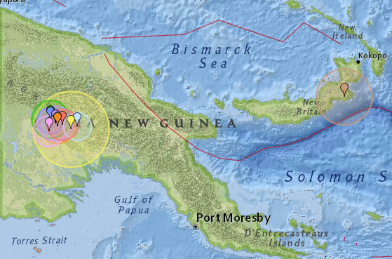
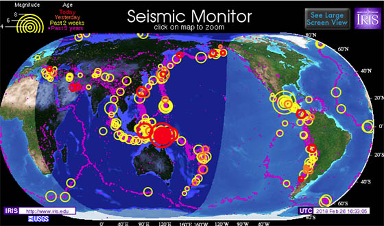
Update: Monday March 5, 2018 ... Papua New Guinea earthquake death toll rises to 67 after latest 6.0 quake CNN
The latest aftershocks, which included a magnitude 6 quake, struck on Monday in the same area, about 600 km (370 miles) northwest of the capital Port Moresby, according to the US Geological Survey. The country's Prime Minister, Peter O'Neill, has declared a state of emergency in the affected areas. The region is largely rural with no major urban centers, but around 670,000 people live within 100 km (62 miles) of the quake's epicenter.
Sunday March 25, 2018 ... The first time I read about Papua New Guinea was twenty years ago - July 17, 1998 when a 7.0 earthquake struck their north coast. It caused a large undersea landslide, which in turn caused a tsunami that hit the coast killing more than 2,200 people. That event triggered a memory of PNG and End Times as if a focal point. To this day I follow tectonic activity in PNG and find most of the energies there unsettling. As if by design a few hours after I posted Magnitude 7.5 earthquake hit Papua New Guinea. Is someone trying to tell me something or confirm a memory?
Monday February 26, 2018 ... Breaking: Earthquakes Hit Papua New Guinea (7.5) And Off Fukushima In Japan (5.6) Forbes
1906 film of San Francisco after earthquake found at flea market Mercury News - March 5, 2018
1906 film of San Francisco after earthquake found at flea market. In this undated file photograph, people walk through the rubble following the April 18, 1906 earthquake in San Francisco. The quake lasted for less than a minute, but the fires burned for three days, roaring across 430 blocks in what was then the 10th largest city in the United States. The San Francisco Chronicle reported Saturday, March 4, 2018, that a long-lost film reel with nine minutes of footage capturing San Francisco two weeks after the deadly 1906 earthquake surfaced at a flea market in the city. The rare find portrays the city's post-quake devastation. More than a century after San Francisco's deadly 1906 earthquake, a film reel with nine minutes of footage capturing the city two weeks after the devastation surfaced at a flea market and it will soon be shown to the public, according to a newspaper report. The long-lost find portrays some of the city's post-quake decimation, including City Hall with its dome nearly destroyed, the San Francisco Chronicle said Saturday. Much of the city was flattened and thousands were killed in the so-called �great quake� and ensuing fire on April 18, 1906.
Bay area earthquake swarm edges toward the major Calaveras Fault Temblor - February 25, 2018
During the past week, 75 quakes have rattled the beautiful town of Danville, scene of the beloved Robin Williams movie, Mrs. Doubtfire. The quakes are occurring at a depth of 5-7 km (3-4 mi) on a heretofore unmapped fault or set of faults, and exhibit a diversity of mechanisms, some similar to the �right-lateral' (whichever side you are on, the other side moves to the right) Calaveras Fault, and others perhaps related to the �blind thrust fault' that has jacked up Mount Diablo. Although most of the quakes in this week's swarm are 3-5 km (2-3 mi) from the Calaveras Fault, the swarm has been migrating toward the Calaveras over the past few days.
Swarm of earthquakes rattles San Francisco Bay Area LA Times - February 25, 2018
Several magnitude 2 and 3 earthquakes rumbled through the San Francisco Bay Area on Friday. It's the latest seismic activity to add to a swarm of 60 earthquakes greater than magnitude 1 to hit the Danville area in the past week.
The largest in the sequence, a magnitude 3.6 earthquake, came at 12:19 p.m. Friday. The U.S. Geological Survey received reports from more than 1,000 people who said they felt the quake, extending from the East Bay and into San Francisco. The quake was quite shallow, less than a third of a mile under the surface of the earth.
Are earthquakes in the mountains really becoming more frequent? ABC - February 25, 2018
The mountains of Western North Carolina are among the oldest in the world. Underneath the soil lies a deep geological history of moving and shaking, but faults, or divisions between plates in the Earth's crust, under the Blue Ridge haven't been active in about 300 million years. Active faults are likely to become the source of another earthquake in the future. Geologists commonly consider faults to be active if there has been movement observed or evidence of seismic activity during the last 10,000 years. But, just because faults under WNC aren't active, doesn't mean there aren't forces at play which could shake things up from time to time. Faults and fractures under the Blue Ridge seldom lead to any shaking that can be felt, and they almost never cause damage. The majority of earthquakes detected have a magnitude of 2.5 or less, but there have been two quakes with a magnitude 5.0 or greater in the last century and a half.
4.4 Earthquake felt across much of England and Wales BBC - February 17, 2018
7.2 earthquake in southeastern Mexico CNN - February 17, 2018
7.2 magnitude earthquake rocks Mexico, 2 killed in chopper crash ABC - February 17, 2018
Study finds earthquakes continue for years after gas field wastewater injection stops PhysOrg - February 13, 2018
Efforts to stop human-caused earthquakes by shutting down wastewater injection wells that serve adjacent oil and gas fields may oversimplify the challenge. The seismologists analyzed a sequence of earthquakes at Dallas Fort Worth International Airport and found that even though wastewater injection was halted after a year, the earthquakes continued. The sequence of quakes began in 2008, and wastewater injection was halted in 2009. But earthquakes continued for at least seven more years.
Is a massive tremor on the way? Ring of Fire activity returns as a series of earthquakes shakes the Pacific plate Daily Mail - February 13, 2018
A flurry of earthquakes has hit Earth's Pacific plate over the past week, renewing fears a massive tremor is on the way after four disasters jolted the region in January. Quakes have hit near Japan, Guam and Taiwan around the planet's so-called 'Ring of Fire', a horseshoe-shaped zone that is a hotbed for tectonic and volcanic activity. Some have suggested the frequency and proximity of the tremors are signs of a bigger earthquake to come. Experts have claimed events around the Ring of Fire are rarely linked and that in most cases adjacent disasters are a coincidence.
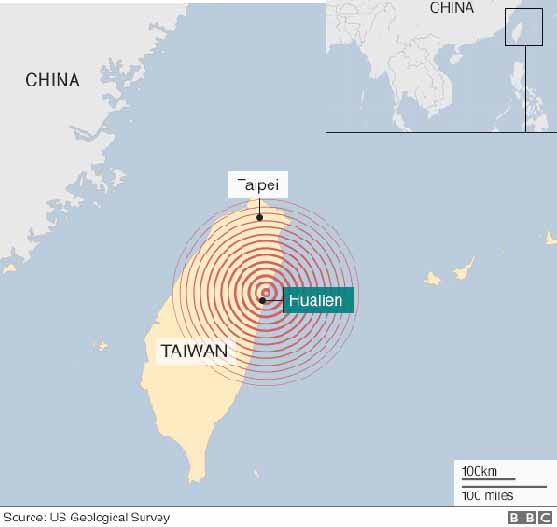
Taiwan earthquake: Series of powerful aftershocks hit Hualien BBC - February 7, 2018
Aftershocks continue to rattle Taiwan after a strong earthquake killed at least seven people and injured more than 250 others on Tuesday night. A 5.7-magnitude tremor was felt late on Wednesday, in the same area where the 6.4-magnitude quake struck on the country's east coast. Some 67 people are still unaccounted for after a number of buildings across the city of Hualien were badly damaged.
Taiwan: 2018 Hualien Earthquake Wikipedia
Strong earthquake prompts tsunami threat message in Caribbean, Mexico CNN - January 10, 2018
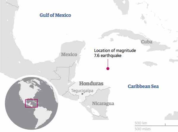
Upsurge in big earthquakes predicted for 2018 as Earth rotation slows The Guardian - November 17, 2017
The link between Earth's rotation and seismic activity was highlighted last month in a paper by Roger Bilham of the University of Colorado in Boulder and Rebecca Bendick of the University of Montana in Missoula presented at the annual meeting of the Geological Society of America.
The correlation between Earth's rotation and earthquake activity is strong and suggests there is going to be an increase in numbers of intense earthquakes next year. In their study, Bilham and Bendick looked at earthquakes of magnitude 7 and greater that had occurred since 1900.
Geologists report new discoveries about Kansas, Oklahoma earthquakes PhysOrg - December 14, 2017
As concern rises about earthquakes induced by human activity like oil exploration, geologists at the University of Kansas report a new understanding about recent earthquakes in Kansas and Oklahoma. This breakthrough may one day lead to a method for predicting where induced earthquakes might occur and may help the energy industry and regulators decide where they can safely place wells.
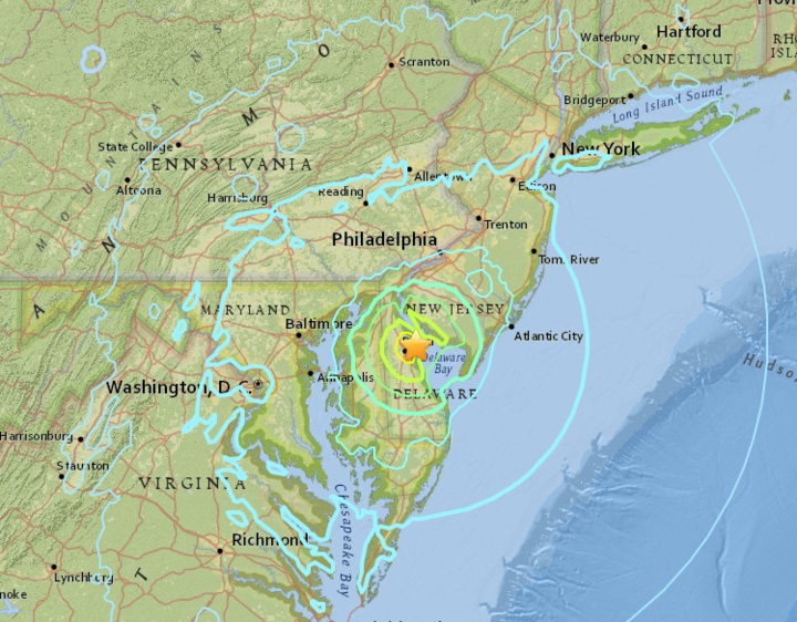
4.1 Delaware Quake - 6.7 Mid-Atlantic Ridge Quake November 30, 2017
Deadly earthquakes could hit a billion people next year because of Earth's slowing rotation Daily Mail - November 20, 2017
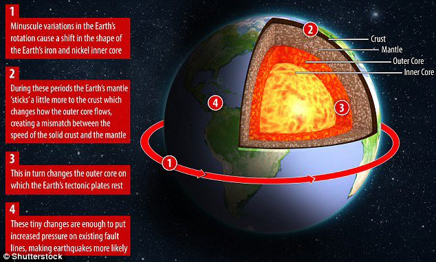
Swarms of devastating earthquakes are set to arrive next year due to the slowing of Earth's rotation, scientists claim. Experts warn we 'had it easy this year' with just six severe earthquakes. Next year we could have at least 20 serious earthquakes, and the most intense ones are expected to occur in tropical regions, home to around one billion people. Tiny changes in the speed of our planet's rotation will trigger huge seismic activity by releasing vast amounts of underground energy, experts claim - although their research has been rejected by some scientists.
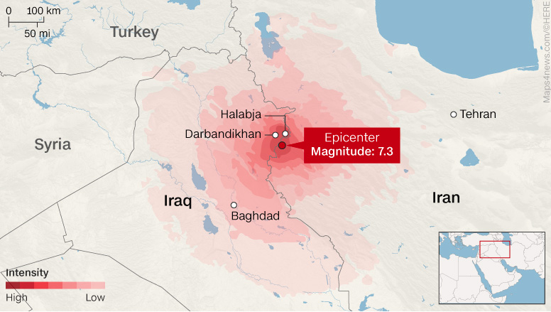
Powerful Iran-Iraq earthquake is deadliest of 2017 CNN - November 13, 2017
Monday's death toll has overtaken September's Mexico City earthquake in which 369 people lost their lives.
2017 Kermanshah 7.3 Earthquake Wikipedia
Earthquake risk elevated with detection of spontaneous tectonic tremor in Anza Gap PhysOrg - October 26, 2017
Scientists at the University of California, Riverside have detected spontaneous tectonic tremor - a signature of slow earthquakes deep below the earth's surface - in the Anza Gap region of the San Jacinto Fault. Tectonic tremors are believed to increase the likelihood of a moderate to large, damaging earthquake occurring close to the earth's surface by altering the stress along the fault.
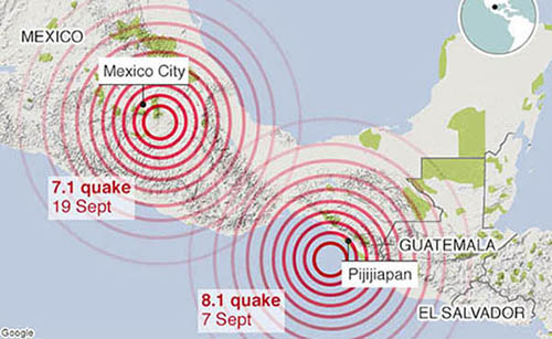
September 7, 2017 Chiapas earthquake Wikipedia
September 19, 2017 Puebla earthquake Wikipedia
2 new quakes shake southern Mexico, already coping with disasters CNN - September 24, 2017
Two more earthquakes shook southern Mexico on Saturday, further rattling a country still coming to grips with the devastation from stronger temblors earlier this month. A 6.1 magnitude earthquake Saturday morning was centered in Oaxaca state near Matias Romero, a town about 275 miles southeast of Mexico City, the US Geological Survey said. Roughly speaking, the epicenter was between the centers of this month's two more violent earthquakes -- the 7.1 magnitude temblor that hit Tuesday closer to the capital, and the 8.1 magnitude quake that struck September 8 off the southern Pacific coast, near Chiapas state.
Are Mexico's two September earthquakes connected? BBC - September 20, 2017
Mexico had barely begun to deal with the aftermath of one big quake before another rocked the country. People will naturally ask: are they related? Did one cause the other? Seismologists will spend a good deal of time in the coming months debating this issue, but on the face of it they look to be unconnected. The 7 September, magnitude 8.1 event certainly struck a similar region of the tectonic boundary, but the hypocentre - the point of origin within the Earth - was some 650km (400 miles) from Tuesday's magnitude 7.1. If the second quake were an aftershock you would normally expect a closer proximity, say seismologists - within 100km. That's not a definitive statement and scientists are sure to pore over the data as it comes in. Perhaps they will eventually identify a way in which stress was transferred within the crust.
Mexico suffers volcano eruption of Mt. Popocatepetl same day as deadly quake New York Post - September 20, 2017
Popocatepetl - about 45 miles southeast of quake-ravaged Mexico City and some 30 miles from the temblor's epicenter - belched ash and gas as the 7.1-magnitude earthquake rocked the country's central region. The county's volcano-monitoring system registered one explosion and 256 'low-intensity exhalations' between Tuesday and Wednesday mornings but said none of the activity can be attributed to the earthquake, according to Mexico's National Center for Prevention of Disasters. A church in Atzitzihuacan at the foot of the mountain collapsed during the quake and eruption, killing 15 worshippers as they celebrated Mass inside.
Minor 3.6 earthquake below the greater Los Angeles Area Earthquake Report - September 19, 2017
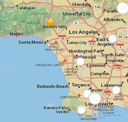
Mexico earthquake crumbles concrete buildings, sending deadly warning to California LA Times - September 22, 2017
Seismic safety experts long have warned that brittle concrete frame buildings pose a particularly deadly risk during a major earthquake. But a horrifying video taken during this week's magnitude 7.1 Mexico quake may do more to highlight the risk than years of reports and studies. In it, sirens blare, utility poles sway. Then in the background, a building wobbles. Concrete starts falling out of a ground-floor column. Then the columns flex, and the upper floors come crashing down, sinking into a cloud of dust.
2017 North Korean nuclear test Wikipedia
The United States Geological Survey reported an earthquake of 6.3-magnitude not far from North Korea's Punggye-ri nuclear test site. South Korean authorities said the earthquake seemed to be artificial, consistent with a nuclear test. The USGS, as well as China Earthquake Networks Center, reported that the initial event was followed by a second, smaller, earthquake at the site, several minutes later, which was characterized as a collapse of the cavity.
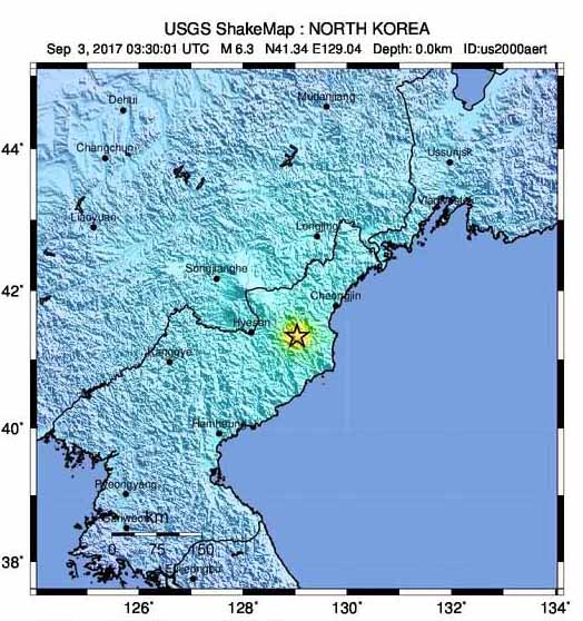
Quakes could be aftershocks from earlier North Korean nuclear test CNN - September 23, 2017
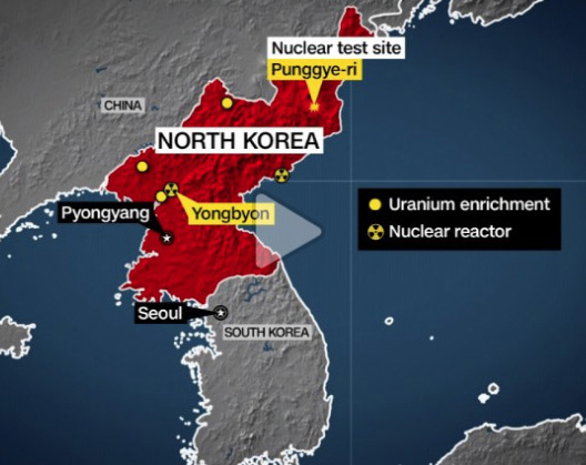
North Korea: Mystery quake 'not nuclear test' BBC - September 23, 2017
A shallow magnitude 3.4 tremor has been detected near North Korea's nuclear test site, but experts believe it was a natural earthquake.
South Korea said the specific soundwaves of man-made quakes were not recorded, while China said the tremor's features were of a natural quake. International nuclear test monitors expressed a similar view. North Korea - which has recently carried out a series of nuclear tests - has so far made no comments. Pyongyang's latest massive nuclear test on 3 September was widely condemned at the UN, triggering more international sanctions against North Korea.
China 7.0 earthquake: Sichuan tremor leaves least 19 dead BBC - August 9, 2017
A 7.0-magnitude earthquake has killed at least 19 people and injured 247 in China's south-western province of Sichuan. Six tourists are thought to be among the dead, with up to 45,000 people evacuated from the area. A separate 6.6-magnitude tremor struck the remote area of XinJiang, injuring 32 people. More than 87,000 people were killed in an earthquake in Sichuan province in 2008.
Yellowstone has now been hit by a record breaking 'megaswarm' of 1,200 earthquakes in just a month Daily Mail - July 21, 2017
Yellowstone National Park has been hit by more than 1,200 earthquakes in the span of just a month, seismologists say.
In the most recent update on the ongoing earthquake storm, which scientists have been monitoring since June 12, the researchers say there have been 1,284 events so far, with the largest being a magnitude 4.4 While the activity has spurred fears that the supervolcano could be gearing up to an eruption, the experts say the risk of such an event is low, and the alert level remains at normal.
How the killer earthquake devastated Greek and Turkish resorts: Science behind the tsunami that ripped across the Aegean Sea is revealed Daily Mail - July 21, 2017
A powerful earthquake struck off the coast of Turkey last night, leaving two dead and hundreds more injured.
The magnitude-6.7 quake triggered a colossal tsunami, which swept through the country's Aegean coast and Greek holiday islands including Kos and Rhodes, leaving devastation in its path. But how do they form and is there a way of stopping them? Tsunamis such as this one are generated when larges swathes of the sea floor become disturbed by large and shallow earthquakes, caused by the turbulent movement of tectonic plates. Scientists studying the behavior of tsunamis hope that deep-ocean sound waves could one day prevent the killer waves from reaching the shore.
Aegean Sea 6.7 Earthquake Rocks Greece, Turkey Resorts: Two Dead on Kos NBC - July 21, 2017
Two people were killed and at least 100 injured after a magnitude-6.7 earthquake rocked popular Greek and Turkish tourist destinations on the Aegean Sea early Friday, the U.S. Geological Survey and officials said. The earthquake sent tourists and locals running into the streets on the Greek island of Kos and the Turkish port city of Bodrum shortly after 1.30 a.m. (6.30 p.m. Thursday ET). Both destinations are popular with European vacationers during the summer high-season.
5.8 magnitude earthquake hits western Montana CNN - July 6, 2017
A 5.8 magnitude earthquake struck western Montana early Thursday, according to the US Geological Survey. The earthquake was 13.6 kilometers (8.4 miles) in depth and was about 33 miles northwest of Helena, the capital, according to USGS. It struck about 7 miles southeast of Lincoln, which has a population of 1,013. Residents as far as Spokane, Washington, and Seattle reportedly felt the first tremors shortly after midnight. Several 911 call centers reported being swamped, but there was no early word of injuries or major structural damage, the station reported.
Solomon Islands hit by earthquake with magnitude of 7.9 sparking tsunami warning Daily Mail - January 22, 2017
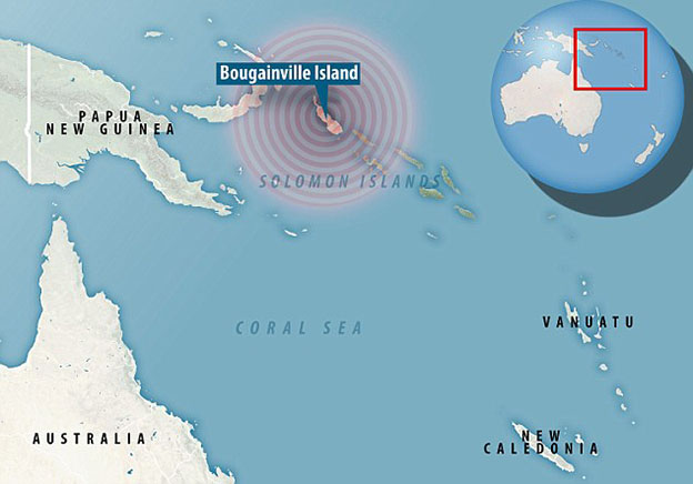
Solomon Islands hit by earthquake with magnitude of 7.9 sparking tsunami warning
Is there a connection between activity at CERN (LHC) and ongoing earthquakes - and the resulting Avalanche - in Italy? Are the experiments stressing the fault lines? The Large Hadron Collider lies in a tunnel 27 kilometres (17 mi) in circumference, as deep as 175 metres (574 ft) beneath the Franco-Swiss border near Geneva, Switzerland. I wonder if the LHC will open a wormhole or black hole to the source of origin or another time stream.
Thursday ...
Many feared dead as avalanche buries Italian hotel after earthquakes CNN - January 19, 2017
At least one person has died and many others are feared dead after an avalanche buried a hotel in central Italy following a series of earthquakes. At least 22 guests and several staff members were in the Hotel Rigopiano, at the foot of the Gran Sasso mountain, when it was hit by the avalanche on Wednesday, Antonio Crocetta, a rescue group leader in the area told Italian state media.
Video inside the hotel Independent - January 19, 2017
Wednesday
Rome metro evacuated as 5.3-magnitude earthquake rocks Italy CNN - January 18, 2017
4 tremors 20 minutes apart ... The metro system and some schools in Italy's capital, Rome, were being evacuated Wednesday following an earthquake that struck the country's heart. A 5.3-magnitude quake hit central Italy 7 kilometers (4.3 miles) west-northwest of Amatrice, a town devastated by a series of powerful temblors last year, the US Geological Survey reported. It struck at 10:25 a.m. (4:25 a.m. ET) at a shallow depth of 10 kilometers (6.2 miles), it reported. It was followed by a more powerful 5.4-magnitude aftershock. There are no immediate reports of casualties or damage. Nearly 300 people were killed in central Italy in an August quake and a series of aftershocks that reduced much of Amatrice's center to rubble.
4 Quakes hit snow-bound central Italy BBC - January 18, 2017
Central Italy has been struck by a series of earthquakes, as the region shivers in freezing temperatures. The biggest quake was 5.4 in magnitude and struck an area devastated by earthquakes in August.
The tremors hit between 10:25 (9:25 GMT) and 11:25 and were felt as far away as Rome. Almost 300 people died in the mountainous region around Amatrice last year. There are no reports so far of any injuries in the latest quakes.
Huge 7.3 earthquake strikes the Philippines Independent - January 13, 2017
A major undersea earthquake with a magnitude of 7.3 struck southeast of the Philippines on Tuesday, the US Geological Survey (USGS) said.
Magnitude 7.2 Quake Hits Near Fiji; Tsunami Alert Issued New York Times - January 3, 2016
A powerful earthquake struck off the coast of Fiji on Wednesday, prompting a brief tsunami warning for the Pacific island nation. There were no immediate reports of damage. The magnitude 7.2 quake, which hit at 9:52 a.m. local time, struck about 220 kilometers (135 miles) southwest of the tourist hub of Nadi, the U.S. Geological Survey said. The quake was a relatively shallow 15 kilometers (9 miles) deep. Shallower quakes generally cause more damage than ones that strike deeper.
Earthquake swarm rocks New Year's Eve in California town CNN - January 2, 2016
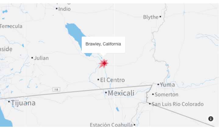
Dozens of earthquakes helped bring in the New Year around Brawley, California, but they are more of a curiosity than a concern, experts tell CNN. Caltech seismologist Lucy Jones said earthquake "swarms" aren't unexpected around Brawley -- there also was a swarm in 2012 -- because the fault-riddled region called the Brawley Seismic Zone lies between the large San Andreas Fault and the Imperial Fault. More than 100 earthquakes have hit the region this weekend, but most are too weak, under 2.5 magnitude, to be noticed by people, said Donyelle Davis, spokeswoman for the United States Geological Survey. Weak quakes can trigger a bigger, more dangerous quake, but Brawley, a city of about 25,000 people near the Mexican border, is too far from the San Andreas Fault for that to be much of a risk, Davis said.
[Note Mammoth Lakes reference from the Eskimo Woman Prophecy]
3.1 earthquake strikes near Mammoth Lakes LA Times - January 17, 2017
A shallow magnitude 3.1 earthquake was reported Tuesday evening 14 miles from Mammoth Lakes, according to the U.S. Geological Survey. The temblor occurred at 6:53 p.m. at a depth of 2.5 miles. According to the USGS, the epicenter was 67 miles from Clovis, Calif., 67 miles from Sanger, Calif. and 70 miles from Reedley, Calif. In the last 10 days, there have been three earthquakes of magnitude 3.0 or greater centered nearby. This information comes from the USGS Earthquake Notification Service, and this post was created by an algorithm written by the author.
Three large quakes hit near Nevada-California state line LA Times - December 28, 2016
The first temblor occurred at 12:22 a.m. Pacific time with a magnitude of 5.7 near Hawthorne, Nevada. At least seven quakes with magnitudes between 3-5.6 were reported shortly after.
Earthquakes in Nevada Felt Throughout Northern California FOX - December 28, 2016
Eskimo Woman Prophecy about Mammoth Mountain
Earthquakes shake Sonoma County, Mammoth Lakes, Central Coast LA Times - December 14, 2016
Several earthquakes hit various parts of California in the last 12 hours, including a swarm of minor temblors in the Mammoth Lakes area and a 5.0 magnitude quake in Sonoma County. Mammoth Lakes, which has a history of seismic activity, recorded a 3.9 magnitude temblor Tuesday night that was followed by scores of aftershocks. The quake was felt in the area but no damage was reported. A 3.9 quake was recorded in the town of Templeton on the Central Coast around 4 a.m. It was followed by a 3.0 aftershock. Then, a 5.0 magnitude quake was recorded in Cloverdale in Sonoma County. No damage was immediately reported from that quake, but it was felt across the north San Francisco Bay and as far south as the San Francisco peninsula, according to the U.S. Geological Survey. A 3.0 aftershock followed.
7.7 Chile earthquake triggers tsunami warning BBC - December 25, 2016
An earthquake with a preliminary magnitude of 7.7 off the coast of Chile has prompted a tsunami warning.
The quake struck 225km (140 miles) south-west of Puerto Montt in southern Chile at 14:22 GMT, the United States Geological Survey (USGS) said. Its depth was about 15km (10 miles). There are no details yet of damage. Chile's national emergency office has issued an alert and ordered the evacuation of coastal areas of Los Lagos region.
Powerful 7.5 quake jolts Peru-Brazil border RT News - December 18, 2016
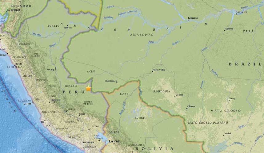
A powerful 7.5 magnitude earthquake, initially reported as 6.9, has struck eastern Peru, close to the border with Brazil, according to USGS. The quake was extremely deep, some 600 kilometers below ground level. Besides Peru and Brazil, shaking has also been felt in neighboring Bolivia. The epicenter of the quake was located in an unpopulated area of the Amazon Basin, 175 kilometers from the closest Peruvian town of Iberia, and some 250 km from the Brazil's Brasileia and Bolivia's Cobija.
Powerful earthquake strikes Papua New Guinea, tsunami warning issued Mirror - December 17, 2016
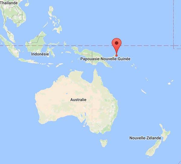
A magnitude 7.9 earthquake has struck off the east coast of Papua New Guinea, according to reports. The Pacific Tsunami Warning Centre has said widespread hazardous tsunami waves are possible. Earthquake-Report.com says that although massive earthquakes are very common in PNG, there are fears for tsunami waves potentially metres in height. According to the Joint Australian Tsunami Warning Centre there is no tsunami threat to the Australian mainland, islands or territories. However, hazardous tsunami waves could hit coastal areas of Papua New Guinea, the Solomon Islands, Indonesia, Nauru and other islands in the three hours following the quake, the Pacific Tsunami Warning Centre said. The quake occurred 60 kilometres east of Taron on New Ireland island at 9.51pm AEDT on Saturday at a depth of 73.4 kilometres.
Tsunami threat over after 7.8 quake near Solomon Islands CNN - December 8, 2016
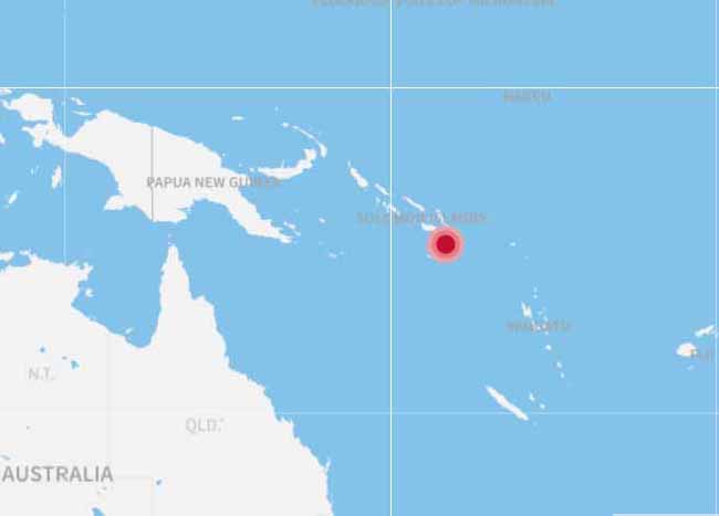
A 7.8-magnitude earthquake hit close to the Solomon Islands early Friday, putting that nation and others in the South Pacific on alert for a tsunami. "Based on all available data, a tsunami may have been generated by this earthquake that could be destructive on coastal areas, even far from the epicenter. An investigation is underway to determine if there is a tsunami threat to Hawaii," the Pacific Tsunami Warning Center said. The earthquake hit less than 30 kilometers off the island of Makira - and 70 kilometers southwest of the city of Kirakira on that island -- about 4:38 a.m. local time Friday (12:38 p.m. ET Thursday).
6.5-magnitude earthquake off the coast of California CNN - December 8, 2016
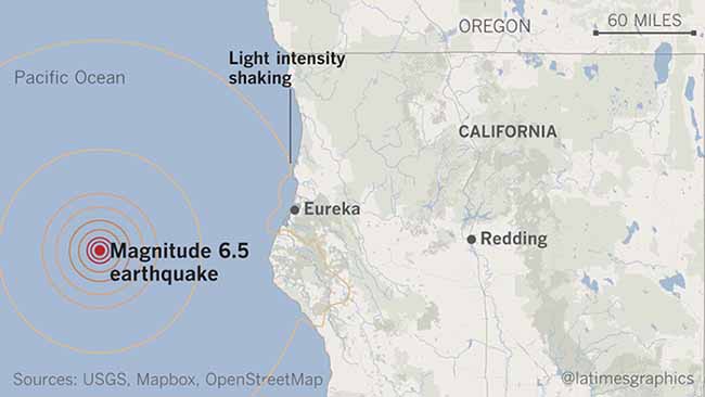
A 6.5-magnitude earthquake shook the ocean floor about 100 miles off the northern California coast Thursday morning, causing weak to light shaking in coastal communities in parts of that state and Oregon, the US Geological Survey said. The quake, centered about 102 miles west of Ferndale, California, happened around 6:50 a.m. PT. Light shaking was reported from east central Oregon to areas a few dozen miles south of San Francisco, the USGS said.
Deadly magnitude 6.5 earthquake hits Aceh in Indonesia BBC - December 7, 2016
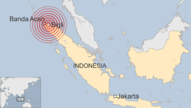
An earthquake off Indonesia's northern Aceh province has killed at least 97 people, say local military officials. The magnitude 6.5 quake struck just off the north-east coast of Sumatra island, where dozens of buildings have collapsed and many people are feared trapped under rubble. In 2004, a huge undersea quake off the coast of Aceh caused a tsunami that killed more than 160,000 people in Indonesia alone. There was no tsunami after Wednesday's tremor, which the US Geological Survey said struck just offshore at 05:03 local time (22:03 GMT Tuesday) at a depth of 8km.
Scientists Pinpoint How to Calm Oklahoma's Human-Made Quakes Live Science - November 30, 2016
Human-induced earthquakes have rattled Oklahoma in recent years, a state known more for its wide-open plains than havoc-wreaking temblors. But now, scientists said they may know how to calm the shaking. In a new study, researchers found that limiting the amount of wastewater pumped into wells deep underground could reduce the number of widely felt earthquakes measuring magnitude 3.0 or higher. This water is pumped as part of the oil and gas production process in Oklahoma and other states in the central and eastern United States. Injecting wastewater from oil and gas extraction into underground wells has occurred for decades in Oklahoma without raising concern over induced seismicity, but in 2009, the rate and volume of injection massively increased, according to the study. Researchers estimate that billions of barrels of wastewater were injected over the past six years into the Arbuckle formation, a highly permeable rock unit in Oklahoma that sits atop billion-year-old rocks containing numerous faults. In 2015, due to underground pressure buildup from injections, earthquake activity in parts of Oklahoma increased 900-fold compared to past levels, according to researchers.
The 7km abyss deep under the ocean: Biggest fault on Earth found inside the deadly 'ring of fire' Daily Mail - November 28, 2016
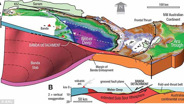
It is a terrifying abyss, 7km deep. Now, geologists have for the first time seen and documented the Banda Detachment fault in eastern Indonesia - and worked out how it formed. It could lead to a breakthrough in tsunami prediction for the area, which is part of the Ring of Fire - an area around the Pacific Ocean basin known for earthquakes and volcanic eruptions.
I dreamed about the Pacific Plate cracking again. It looks like a gigantic concrete shelf that rises up in front of me. Each time I "see" or dream about it, the plate rises higher and higher.
Earthquake hits off coast of Central America CNN - November 24, 2016
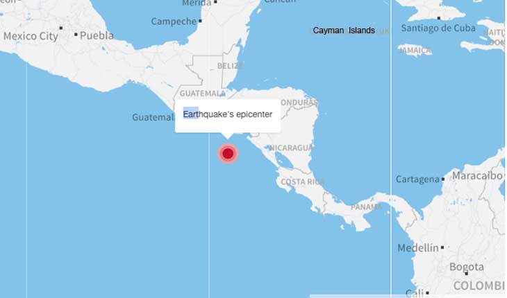
A 7.0-magnitude earthquake struck off the coast of Central America on Thursday afternoon, the US Geological Survey said. The quake hit at a depth of 10.3 kilometers (6.4 miles) about 149 kilometers (93 miles) south-southwest of Puerto El Triunfo, El Salvador, USGS said.
6.9-magnitude earthquake strikes off Japan + Aftershocks and possible Tsunami CNN - November 22, 2016
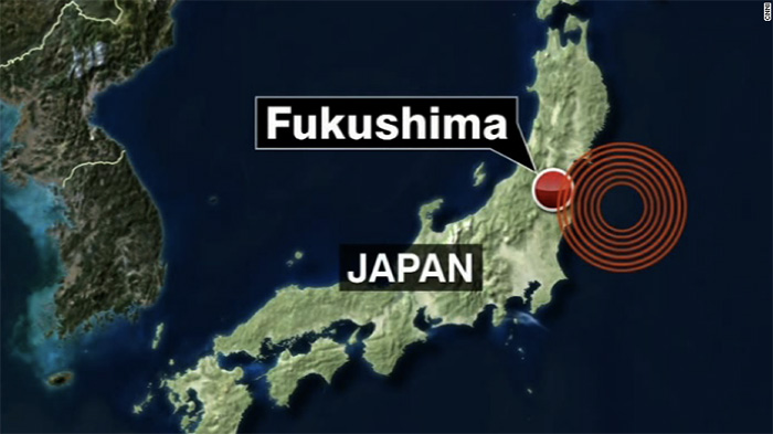
A 6.9-magnitude earthquake struck off Japan's Honshu island on Tuesday, triggering tsunami waves and bringing back traumatic memories for locals of the devastating 2011 Fukushima disaster. Residents in Fukushima Prefecture braced for the worst after a tsunami warning was issued early Tuesday morning -- along the same stretch of coast devastated by enormous waves five years ago. In 2011, a 9.0-magnitude earthquake -- one of the worst ever to hit Japan -- killed more than 20,000 people and caused tsunamis of up to 12 meters (40 feet) which swamped the Fukushima Daiichi nuclear power plant, triggering a nuclear meltdown.
6.4 magnitude earthquake shakes western Argentina CBC News - November 20, 2016
A magnitude 6.4 quake on Sunday hit western Argentina, northeast of Santiago, the capital of neighboring Chile, the U.S. Geological Survey said. The quake's epicenter was 16 miles (25.75 km) southwest of the Argentine town of San Juan, and about 180 miles (290 km) northeast of Santiago in Chile. The tremor was initially reported as a magnitude 6.7 but was later downgraded. Although a magnitude 6.4 is considered a strong earthquake capable of causing severe damage, it was fairly deep - 71.9 miles (115.71 km) below the Earth's surface, which would have lessened its effects.
New Zealand Quake Ruptured 6 Faults Live Science - November 21, 2016
The magnitude-7.8 quake that rattled New Zealand on November 14, killed at least two people and stranded thousands of others, completely transforming the underlying faults in the region. Six major faults ruptured as a result of the quake, a new map reveals. The Kaikoura earthquake struck the South Island of New Zealand early in the morning on Nov. 14 local time, triggering landslides, tsunamis and hundreds of aftershocks. And thousands of people were stranded when earthquake detritus dammed a river. During the quake, bystanders captured images of mysterious earthquake lights painting the sky in eerie blue and green.
Is this a statement about secret archives hidden under the Vatican about to be revealed but not by choice?
Italy earthquake: 6.6-magnitude tremor rocks nation's center CNN - October 30, 2016
A powerful 6.6-magnitude earthquake rocked central Italy on Sunday morning, according to the United States Geological Survey, sending residents running onto the streets in a panic. Rescuers were seen in the area around crumbling buildings soon after the tremor hit, helping evacuate a group of nuns from a building. They are working through aftershocks, striking every 20 minutes or so.
Italy quake: Powerful tremor near Norcia destroys buildings BBC - October 30, 2016

A strong earthquake has struck near Norcia in central Italy, destroying numerous buildings. The quake comes nearly two months after a major earthquake killed almost 300 people and destroyed several towns. The quake early on Sunday measured 6.6, larger than August's quake and aftershocks last week. It is thought to be Italy's most violent in decades. At least nine people have been hurt but no deaths are reported so far. Many locals left after last week's quakes. Nine people have been pulled alive from the rubble, Italian media say. Tremors were felt in the capital Rome, and as far away as Venice in the north. It was at a depth of only 1.5km (0.9 miles)
Italy earthquakes: Strong tremors shake central region BBC - October 26, 2016
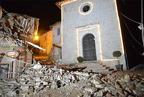
Two strong earthquakes have hit central Italy, damaging buildings and sending scared residents into the streets. A 5.5-magnitude quake struck at 1910 local time (1710 GMT) near Visso in Macerata province, officials said. It was followed two hours later by a 6.1 magnitude tremor in the same area. One person was hurt, but there were no immediate reports of deaths.
Entire Himalayan arc can produce large earthquakes Science Daily - October 26, 2016

The main fault at the foot of the Himalayan mountains can likely generate destructive, major earthquakes along its entire 2,400-kilometer (1,500-mile) length, a new study finds. Combining historical documents with new geologic data, the study shows the previously unstudied portion of the fault in the country Bhutan is capable of producing a large earthquake and did so in 1714. The Himalayas have produced some of the world's largest earthquakes, like the April 2015 Gorkha earthquake.
New fault discovered in earthquake-prone Southern California region PhysOrg - October 4, 2016
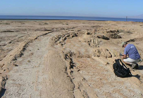
A swarm of nearly 200 small earthquakes that shook Southern California residents in the Salton Sea area last week raised concerns they might trigger a larger earthquake on the southern San Andreas Fault. At the same time, scientists from Scripps Institution of Oceanography at the University of California San Diego and the Nevada Seismological Laboratory at the University of Nevada, Reno published their recent discovery of a potentially significant fault that lies along the eastern edge of the Salton Sea. The presence of the newly mapped Salton Trough Fault, which runs parallel to the San Andreas Fault, could impact current seismic hazard models in the earthquake-prone region that includes the greater Los Angeles area. Mapping of earthquake faults provides important information for earthquake rupture and ground-shaking models, which helps protect lives and reduce property loss from these natural hazards.
Scientists discover magma buildup under New Zealand town PhysOrg - June 6, 2016
Scientists say they've discovered a magma buildup near a New Zealand town that explains a spate of recent earthquakes and could signal the beginnings of a new volcano - although they're not expecting an eruption anytime soon.
Economic losses from natural disasters counted BBC - April 18, 2016
Are the Ecuador and Japan earthquakes related? CNN - April 18, 2016
Usually we don't think earthquake are connected across the ocean, but there's ongoing research in "remote triggering," the idea that a big quake can cause another quake a long distance away. The distance between Japan and Ecuador: 15,445 kilometers, or about 9,590 miles.
April 2016 Ecuador 7.8 earthquake
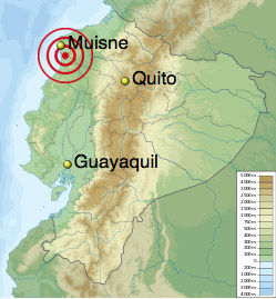
8.3 Chile quake: State of emergency declared for Coquimbo BBC - September 17, 2015
Chile earthquake: 8.3-magnitude temblor strikes off coast, killing 5 CNN - September 17, 2015
The 2015 Nepal 7.8 earthquake (also referred to as the Himalayan earthquake) occurred at 11:56 NST on April 25, 2015. Its epicenter was approximately 34 km (21 mi) east-southeast of Lamjung, Nepal, and its hypocenter was at a depth of approximately 15 km (9.3 mi). It is the most powerful disaster to strike Nepal since the 1934 Nepal�Bihar earthquake. As of 27 April, more than 3,700 people are believed to have died as a result, with casualties reported in Nepal and adjoining areas of India, China, and Bangladesh.
The earthquake triggered an avalanche on Mount Everest, killing at least 17. The death toll surpassed that of the 2014 Mount Everest avalanche, making it the most lethal day on the mountain. Centuries-old buildings were destroyed at UNESCO World Heritage sites in the Kathmandu Valley, including some at the Kathmandu Durbar Square. Continued aftershocks occurred throughout Nepal, with one shock reaching a magnitude of 6.7 on 26 April at 12:54:08 NST.
Buildings in the UNESCO World Heritage Site of Kathmandu Durbar Square collapsed, as did the Dharahara tower, built in 1832, killing at least 180 people, and Manakamana Temple located in Gorkha. The northern side of Janaki Mandir has been reported to be damaged. Several temples, including Kasthamandap, Panchtale temple, the nine-storey Basantapur Durbar, the Dasa Avtar temple, Krishna Mandir and two dewals located behind the Shiva Parvati temple, were demolished by the quake. A few other monuments, including the Kumari Temple and the Taleju Bhawani, among others, have partially collapsed. The top of the Jay Bageshwori Temple in Gaushala and some parts of the Pashupatinath Temple, Swyambhunath, Boudhanath Stupa, Ratna Mandir, inside Rani Pokhari, and Durbar High School have been destroyed.
7.1-magnitude earthquake hits North Atlantic Ocean CBC - February 14, 2015
Strongest 6.1 quake in 25 years strikes California's Bay Area CNN - August 24, 2014
2014 Napa Earthquake Wikipedia
Strong quakes around Bardarbunga Volcano BBC - August 24, 2014
April 2016 Japan earthquakes
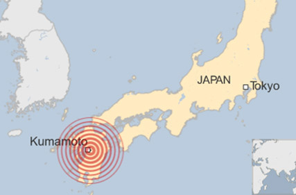
The quake-maker you've never heard of: Cascadia CNN - February 11, 2016
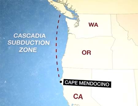
Mother Earth slowly reveals her secrets, and this time, it's a fault line deep in the belly of the planet. Its name is a whopper: The Cascadia subduction zone. Its gargantuan size and potential power amaze earthquake experts, who say it could cause the worst natural disaster in the history of North America -- if it ruptures entirely. This quake-maker sits at the bottom of the Pacific Ocean, where the seabed meets the North American tectonic plate. In all, it stretches 700 miles along the Pacific Northwest, from British Columbia's Vancouver Island to Washington to Oregon to northern California's Cape Mendocino. This quake-maker sits at the bottom of the Pacific Ocean, where the seabed meets the North American tectonic plate. In all, it stretches 700 miles along the Pacific Northwest, from British Columbia's Vancouver Island to Washington to Oregon to northern California's Cape Mendocino.
Chances of Earthquake Hitting L.A. Area Soon: Like, for Sure Live Science - October 21, 2015
The chance of a moderate-size earthquake striking the Los Angeles area soon is almost guaranteed, if a new study is correct. The Greater Los Angeles area has a 99.9 percent chance of having an earthquake of magnitude 5.0 or greater in the next two and a half years, thanks to several hidden faults that have built up considerable strain. But exactly where this next medium-size temblor could strike is less clear, because any one of the many faults that thread through the area could rupture.
September 17, 2015 Illapel earthquake Wikipedia
Chile's government has declared a state of emergency in a central region struck by a powerful earthquake. One million people had to leave their homes and at least 11 people died when the 8.3-magnitude quake hit. In the coastal town of Coquimbo, waves of 4.7m (15ft) hit the shore. Small tsunami waves hit as far away as Alaska.
A powerful 8.3-magnitude earthquake struck Chile, generating a nearly 16-foot wave, prompting the evacuation of about 1 million people and triggering tsunami advisories as far away as California. Authorities reported at least five deaths
Balancing rocks trace history of 'jumping' earthquakes BBC - August 5, 2015

US scientists say they have solved the riddle of why a collection of balancing rocks near the San Andreas fault has never been toppled by earthquakes. Their decade-long study concludes that quakes can stop or "jump" due to interactions between the San Andreas and the neighboring San Jacinto fault. Models show that these interactions sent the biggest vibrations around the rock stacks, leaving them intact. But the connected nature of the faults has implications for quake planning.
Uplifted island PhysOrg - June 22, 2015
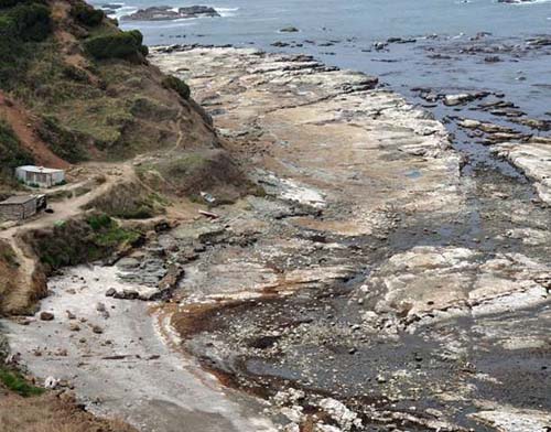
The island Isla Santa Mar�a in the south of central Chile is the document of a complete seismic cycle. At the South American west coastline the Pacific Ocean floor moves under the South American continent. Resulting that through an in- and decrease of tension the earth's crust along the whole continent from Tierra del Fuego to Peru broke alongside the entire distance in series of earthquakes within one and a half century. The earthquake of 1835 was the beginning of such a seismic cycle in this area. After examining the results of the Maule earthquake in 2010 a team for the first time were able to measure and simulate a complete seismic cycle at its vertical movement of the earth's crust at this place.
Origin of Mysterious 'Cannon Earthquakes' in Red Sea Found Live Science - June 15, 2015
Mysterious earthquakes that sound like cannon blasts have been puzzling people for decades, and now their origin has been traced way back to a giant block of volcanic rock hundreds of millions of years old, researchers say. For generations, Bedouin nomads living in the region of the Egyptian coastal resort Abu Dabbab, by the Red Sea, have heard noises that sound like cannon blasts accompanying small quakes in the area. The name of Abu Dabbab are Arabic words that mean 'the Father of Knocks,' which is related to the sound heard in this area.
Indian Subcontinent's Quake-Causing Collision Course New York Times - May 18, 2015

In terms of plate tectonics, India is running into Asia at one and a half to two inches a year, leading to earthquakes. When an unstoppable force like the Indian subcontinent crashes into an immovable object like Asia, the consequences include the tallest mountains in the world and a cadence of earthquakes like the magnitude 7.8 one that struck Nepal last month and a major aftershock in the same region last week.
Magnitude-7.4 earthquake hits off the coast of Papua New Guinea ABC - May 5, 2015
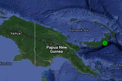 A magnitude-7.4 earthquake off Papua New Guinea has generated a small tsunami and caused minor damage to buildings in the town of Kokopo in East New Britain province. There have been no reports of injuries or major damage to infrastructure.
2015 Nepal earthquake Wikipedia
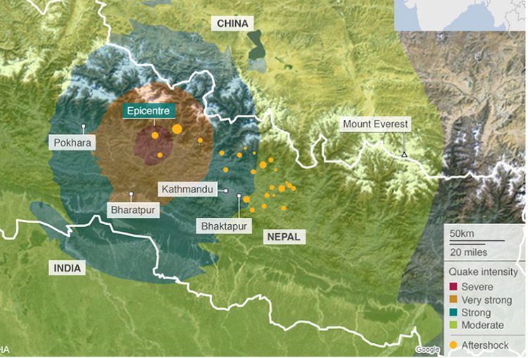
Nepal quake 'followed historic pattern' BBC - April 27, 2015
Nepal's devastating magnitude-7.8 earthquake on Saturday was primed over 80 years ago by its last massive earthquake in 1934, which razed around a quarter of Kathmandu to the ground and killed over 17,000 people. This latest quake follows the same pattern as a duo of big tremors that occurred over 700 years ago, and results from a domino effect of strain transferring along the fault, geologists say.
Bigger Earthquake Coming on Nepal's Terrifying Faults Live Science - April 27, 2015
Nepal faces larger and more deadly earthquakes, even after the magnitude-7.8 temblor that killed more than 4,000 people on Saturday (April 25). Earthquake experts say Saturday's Nepal earthquake did not release all of the pent-up seismic pressure in the region near Kathmandu. According to GPS monitoring and geologic studies, some 33 to 50 feet (10 to 15 meters) of motion may need to be released, said Eric Kirby, a geologist at Oregon State University. The earth jumped by about 10 feet (3 m) during the devastating April 25 quake, the U.S. Geological Survey reported.
Three Idaho quakes rattle residents from Washington to Montana PhysOrg - April 24, 2015
Three earthquakes up to magnitude-4.2 and nearly a half-dozen aftershocks jolted northern Idaho, with residents from Washington state to Montana saying they felt the tremors. othing was damaged in the house during the quake that she estimated lasted several minutes. A second quake of magnitude-4.2 struck a little more than three hours later, waking up Hadley and her dog. That quake was centered 38 miles northeast of Hayden. Then, a magnitude-3.3 temblor hit at 1:28 a.m. Friday in the same area. Also Friday, a magnitude-6.1 earthquake struck British Columbia's north coast, but a tsunami was not expected and no injuries or damage were reported. After the Idaho temblors, hundreds of people logged onto the Geological Survey's National Earthquake Information website to report feeling them.
Washington Earthquake's Mysterious Source Discovered Live Science - April 23, 2015
Geologists have finally solved a 142-year-old earthquake mystery in central Washington state. Until now, no one knew the source of a powerful earthquake that rattled windows from Washington to Montana on Dec. 14, 1872. The quake's size, based on historical accounts, was magnitude 6.8. At the time, newspapers put the epicenter in several areas, from underneath the Puget Sound north to Vancouver, British Columbia. But Washington's eyewitness reports, slower to arrive in the sparsely populated state, centered the most intense damage east of the Cascades, near Wenatchee, where a giant landslide temporarily dammed the Columbia River.
Enhancing earthquake early warning in the Pacific Northwest PhysOrg - April 23, 2015
Earthquake Early Warning (EEW) systems depend on speed and accuracy in delivering seismic monitoring data to areas at risk from a quake or volcanic eruption. Paul Bodin of the University of Washington and colleagues have been testing models of EEW systems within the Pacific Northwest Seismic Network (PNSN) in Washington State and Oregon to learn more about what factors could be improved to provide the most timely warnings for their region. For instance, what's priorities are important for getting a speedy warning to those at risk: the placement of seismic monitoring stations, or the number of stations, or the speed at which data can be transmitted between stations and notification centers?
Titanic Blob of Magma Found Beneath Yellowstone Supervolcano Live Science - April 23, 2015
A giant blob-shaped reservoir of searing-hot rock has been discovered far below the supervolcano underneath Yellowstone National Park - one that could fill the Grand Canyon more than 11 times over, researchers say. The discovery doesn't raise the risk of future eruptions at Yellowstone, the study authors said. However, a better understanding of the Yellowstone supervolcano's plumbing could shed light on any hazards it might pose, scientists added. The newfound blob-shaped magma reservoir lies in the lower crust. The molten rock extends from about 12 to 28 miles (19 to 45 kilometers) deep, and measures about 30 miles (48 km) long northwest to southeast and 44 miles (70 km) long southwest to northeast. This magma reservoir is about 11,200 cubic miles (46,700 cubic km) in size. Video 1
Earthquake potential where there is no earthquake history PhysOrg - April 22, 2015
It may seem unlikely that a large earthquake would take place hundreds of kilometers away from a tectonic plate boundary, in areas with low levels of strain on the crust from tectonic motion. But major earthquakes such as the Mw 7.9 2008 Chengdu quake in China and New Zealand's 2011 Mw 6.3 quake have shown that large earthquakes do occur and can cause significant infrastructure damage and loss of life. So what should seismologists look for if they want to identify where an earthquake might happen despite the absence of historical seismic activity?
We pay attention to earthquake activity involving the Pacific Plate due to ongoing accelerating activity. Monday: Magnitude 6.9 Earthquake Hits Off Northeastern Coast Of Japan, Triggers Minor Tsunamis. It is also important to watch the movement of the North and South American Plates as indicators of bigger things to come. Pay attention to the Mid-Atlantic Ridge whose earthquake activity has increased rapidly in recent years. A larger earthquake can - and will - cause a tsunami.
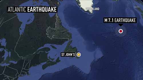
A 7.1-magnitude earthquake hit the mid North Atlantic on Friday - the largest one in 48 years. It happened along the Mid-Atlantic Ridge around 3:30 p.m. NT. The quake was closer to Greenland and Ireland than Newfoundland. It happened about 1,400 kilometres from Iceland, 1,500 kilometres from Ireland, and about 1,700 kilometres from the island. There have been five recorded earthquakes in that area in the last century. Prior to Friday's quake, the largest on record was a 7.0-magnitude quake in 1967. None of the earthquakes in that area are known to have caused any damage.
2.2 Magnitude Quake Is the 12th in a Week NBC - January 15, 2015
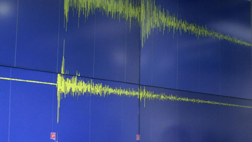
The ground shook again in Eastern Connecticut on Thursday morning as the area experienced its 12th earthquake in a week.
On Friday local and state officials will be holding meetings to inform residents and discuss how prepared the state is should a damaging earthquake strike here. The U.S. Geological Survey listed the earthquake at 4:39 a.m. in the Moosup section of Plainfield as a magnitude-2.2. Moodus is infamous for strange noises coming from the woods which have been termed "Moodus noises", and are attributed to shallow micro-earthquakes. Some residents think doomsday is coming - that this swarm of earthquakes a precursor to something larger. Not yet but their premonitions are correct.
Scientists record four small earthquakes in Connecticut PhysOrg - January 12, 2015
Scientists on Monday recorded four small earthquakes within 20 minutes in the same area of eastern Connecticut, including a 3.1-magnitude tremor felt more than 60 miles away in Massachusetts. They followed two smaller quakes in the same area last week.
Worldwide Surge in 'Great' Earthquakes Seen in Past 10 Years NBC - October 26, 2014
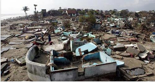
The annual number of "great" earthquakes nearly tripled over the last decade, providing a reminder to Americans that unruptured faults like those in the northwest United States might be due for a Big One.
Expect the Unexpected: More 9.0 Megaquakes Are Coming, Study Says NBC - September 15, 2014
No one should be surprised if a magnitude-9 megaquake erupts off America's West Coast - or anywhere else around the Pacific Ocean's "Ring of Fire," for that matter. That's the upshot of a study in October's issue of the Bulletin of the Seismological Society of America: Researchers say that computer models of future seismic activity, plus a check of past activity going back thousand of years, suggest most of the Pacific's earthquake zones are capable of generating shocks at least as strong as magnitude 9 every 10,000 years on average.
Mysterious Fissure Splits Ground in Mexico Nature World - August 26, 2014
A Massive crack tore through more than a half-mile of ground in northern Mexico, according to numerous local reports. Now experts are struggling to explain what caused it and if it is a threat to public safety. The mysterious trench in question is up-to nearly 16 feet across at its thickets, and stretches for nearly half a mile according to Sky News, one of the first to report this unusual geological event. Hermosillo Sonora Mexico Emergency Management released footage taken by a drone flying over the perplexing crack while motorists remained stopped in their cars on either side of fissured roads as early as Wednesday. It is unclear when the earth was first broken, but residents of northern Mexico reported discovering the fissure earlier this week. Some local officials and experts alike are blaming seismic activity for the phenomenon, with a 5.0 magnitude earthquake occurring only earlier this month.
How the Napa Earthquake Deformed Earth Live Science - September 3, 2014
The 6.0-magnitude earthquake that rocked California's Napa Valley last month not only injured dozens of people and caused millions of dollars in damage, but it also warped the surface of Earth. Satellites with radar vision can see how the Napa earthquake deformed the region from space. Observations from the European Space Agency's (ESA) new Sentinel-1A satellite reveal changes on the surface through a technique known as synthetic aperture radar interferometry.
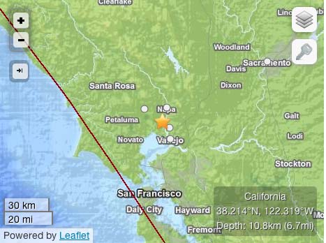
The 2014 Napa earthquake occurred in California, United States, at 10:20:44.00 UTC (3:20am local time) on August 24. The magnitude was measured 6.0 on the moment magnitude scale, and its epicenter was 3.7 miles (6.0 km) northwest of the city of American Canyon, near the West Napa fault. Significant damage was reported in the Napa area, sending at least 87 people to hospitals. More than 42,000 customers lost electric service. It was the largest earthquake to hit the San Francisco Bay Area in since the 1989 Loma Prieta earthquake 25 years earlier.
6.9-magnitude quake strikes Peru, USGS says CNN - August 24, 2014
A strong earthquake struck southern Peru on Sunday evening, injuring at least two people and damaging buildings, authorities said. A house was destroyed and 19 other buildings were damaged, including a hospital, Peru's Emergency Operations Center said. The 6.9-magnitude earthquake hit a mountainous area 43 kilometers (27 miles) east-northeast of Tambo at a depth of 101 kilometers (63 miles), according to the U.S. Geological Survey. 5 most powerful recorded earthquakes The USGS revised down the quake's strength from the magnitude of 7.0 that it initially reported, as well as adjusting its data on the location and depth of the epicenter.
Odds of major quake in Oklahoma growing, here's why USGS - August 22, 2014
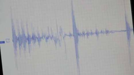
The rate of earthquakes recorded in Oklahoma has increased remarkably in less than a year, the U.S. Geological Survey warned - three months ago - that the chances of a damaging temblor in Central Oklahoma have increased significantly. Further, the federal agency reported that a statistical analysis indicates oilfield wastewater injected into deep geological formations is a likely contributing factor to the increased number of quakes.
Iceland volcano: Eruption under ice-cap sparks red alert BBC - August 24, 2014
Two new earthquakes have shaken the Bardardunga volcano in Iceland, which is already under a "red alert" aviation warning because of fears an eruption. They are the strongest earthquakes to hit the volcano since seismic activity began on Tuesday. Authorities said there had not been a major eruption but have closed the airspace in the area as a precaution.
Iceland's Eyjafjallajokull volcano erupted in 2010, producing ash that disrupted air travel across Europe.
Earthquakes on Arizona-N.M. border felt in Valley AZCentral - June 29, 2014
Four earthquakes occurred overnight between around 10 p.m. Saturday and 7:30 a.m. Sunday along the Arizona-New Mexico border ranging from a 3.4- to 5.2-magnitude, according to the United States Geological Survey. The earthquakes all occurred within the same general location, about 30 miles northwest of Lordsburg, N.M. The largest earthquake, a 5.2-magnitude, occurred around 10 p.m. on Saturday, followed by a 3.5, 3.4 and 3.6-magnitude earthquake that finished Sunday morning, according to USGS. The earthquake occurred within the North American tectonic plate and was caused by a normal spreading of the plate, Presgrave said. He said it is not uncommon to see such instances in the region where the earthquakes occurred due to a gradual spreading of the rock. Arizona residents in Graham County, Safford, Tucson, Gilbert, Mesa, Chandler and other areas have reported feeling the tremor.
Big Earthquakes Double in 2014, But They're Not Linked Live Science - June 28, 2014
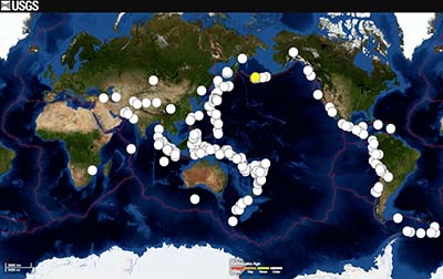
If you think there have been more earthquakes than usual this year, you're right. A new study finds there were more than twice as many big earthquakes in the first quarter of 2014 as compared with the average since 1979.
Photo Journal: The Gorgeous San Andreas Fault Live Science - June 28, 2014
The San Andreas Fault is the most famous fault in the world. In the Colorado Desert of Southern California it begins near the Salton Sea and expresses itself in parts of the Coachella Valley by a range of small mountains, known as the Indio Hills that are fractured and run in various directions as a result of the collision of the Pacific and North American Continental Plates.
We always follow events in the Pacific but now let's have a look at the Atlantic.
Very strong 6.0 earthquake out of the coast of Guadeloupe (Caribbean) Earthquake Report.com - May 16, 2014
he image below shows the Atlantic North American oceanic plate who moves to the West and a Caribbean plate who moves to the East. The oceanic plate dives below the arc with the islands and sometimes hangs (instead of gradually creeping below it). When the energy gets too big the friction area breaks and an earthquake is generated.
Strong Earthquake Shakes Guadeloupe, Antigua and Barbuda Carib Journal - May 17, 2014
A strong 6.0-magnitude earthquake caused shaking in Antigua and Barbuda and Guadeloupe on Friday morning, according to data from the United States Geological Survey. The quake struck at around 7:01 AM local time at a depth of about 24 kilometres. Its epicentre was 113 kilometres northeast of Grand Anse in Guadeloupe and about 155 kilometres east of St John's, Antigua and Barbuda. It was the latest in a string of moderate to strong earthquakes in the Caribbean region in recent months. It was the strongest earthquake in the Caribbean Sea since a 6.4-magnitude quake struck Puerto Rico in January. The quake was followed by several aftershocks of around 4.8 to 5.0 magnitude on the Richter scale. There were also reports of shaking around the Eastern Caribbean region, including in Dominica.
-
The Pacific Plate is coming apart - with the plates sliding over one another. If you're following the news ... from Antarctica north along the Pacific Rim into Canada ... you realize the intensity of earthquake activity - highlighted Tuesday with a 6.8 Earthquake Hits off Panama. Earthquakes along the Pacific rim are no longer in the 4's and 5's but the 6's and 7's. As you know large earthquakes trigger tsunamis. The headline story this week is about the unstoppable Antarctica collapse. It won't be long now. Read more ...
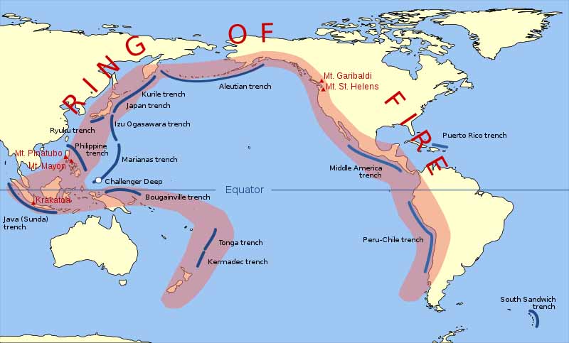
The tectonic plates continue to break up in the notorious Pacific Ring of Fire with an increase in magnitude. Currently we find a 6.9 earthquake off the coast of northern California. Over in the Puerto Rico trench we also find an increase in seismic activity causing earthquakes in Cuba.
Ring of Fire Earthquakes March-April 2014
April 23, 2014
Glass rattled, buildings swayed, but no damage was reported after a magnitude 6.6 earthquake hit off the northern coast of Vancouver Island on Wednesday night. Two aftershocks were reported in the hour following the quake. The first was magnitude 5.0 at 8:20 p.m. and the second magnitude 4.2 at 8:41 p.m. A third aftershock, at 4.2, was recorded at 10:16 p.m. - CBS News
Spike in Earthquakes? An 'Illusion' Raises New Questions NBC - April 21, 2014
Some of the best minds in earthquake science have been counting quakes and analyzing seismic waves to see if the largest in a string of recent quakes - the magnitude-8.2 tremor in Chile on April 1 - might have triggered others far, far away. Experts for years have known that the seismic waves from one quake can trigger a quake somewhere else - a process known as "dynamic triggering."
7.5-magnitude quake strikes off Papua New Guinea CNN - April 19, 2014
An earthquake struck late Saturday off Papua New Guinea's eastern coast with a preliminary magnitude of 7.5, the U.S. Geological Survey said. The quake struck at 11:27 p.m. (9:27 a.m. ET) and occurred at a depth of 19 miles (32 km), the USGS said. It was centered 47 miles (75 km) southwest of Panguna, Papua New Guinea. After the quake, the Pacific Tsunami Warning Center issued a tsunami warning for Papua New Guinea and the Solomon Islands, but then canceled it.
After an earthquake hit the Solomon Islands at 6:28 a.m. Saturday, April 19, the National Weather Service issued a statement that the earthquake poses no tsunami danger to Oregon, Washington, British Columbia, Alaska or California. The earthquake's magnitude was recorded at 7.8, with depth of 6 miles. According to the National Tsunami Warning Center, had the earthquake triggered a tsunami, it would take about 14 hours to reach the Pacific Northwest coast. The region has suffered from a slew of major earthquakes this month, and the Solomon Islands were hit with devastating flash floods earlier in April.
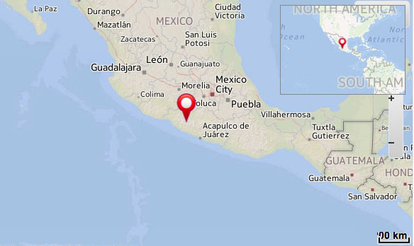
7.5 magnitude earthquake strikes in southern Mexico CNN - April 18, 2014
A powerful earthquake shook central and southern Mexico on Friday. The US Geological Survey calculated its magnitude at 7.5 and said it was centered near the Pacific resort of Acapulco, where many Mexicans are vacationing for the Easter holiday. An Associated Press reporter said it was felt strongly in the resort city but there were no immediate reports of injuries or damage. The quake shook Mexico City for at least 30 seconds, with buildings swaying as people fled high rises and took to the streets. Because of the Easter holiday, that city was less crowded than usual. Mexico City is vulnerable even to distant earthquakes because much of it sits atop the muddy sediments of drained lake beds that quiver as quake waves hit.
New Quake Shakes Nicaragua; Nation on Alert Live Science - April 11, 2014
Another powerful earthquake hit Nicaragua today (April 11), less than a day after an earthquake caused widespread damage and injuries in the capital of Managua and surrounding towns. The magnitude-6.6 temblor struck today at 2:29 p.m. local time according to the U.S. Geological Survey (USGS). Yesterday, a magnitude-6.1 earthquake hit at 5:27 p.m. local time. The magnitude-6.6 quake's epicenter was about 15 miles (24 kilometers) south of Granada. The earthquake originated 86 miles (139 km) deep, much deeper than yesterday's damaging temblor, the USGS reports. The quake was felt widely, including in El Salvador and Costa Rica. More than 250 people were injured during Thursday's earthquake and one woman died of a heart attack, according to SINAPRED, the national disaster management agency.
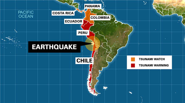
April 2, 2014 Iquique 8.2 earthquake Wikipedia
Chile leader evacuates as 7.6 second big quake strikes BBC - April 3, 2014
Chile quake: This was big but a bigger one awaits, scientist says CNN - April 2, 2014
Chile's Recent Earthquake Defied Expectations Scientific American - April 23, 2014
Monika Sobiesiak wasn't expecting the morning of April 2 to start with such an adrenaline jolt. But as she scrolled through a list of earthquakes on her mobile phone, she saw that overnight a series of quakes had rocked the coast of northern Chile - almost exactly where she had installed a seismometer network a few years earlier.
5.1 Earthquake felt in Los Angeles area of California BBC - March 17, 2014
The quake happened at about 21:10 local time on Friday (04:10 GMT on Saturday) and its epicentre was 1 mile (2km) east of the town of La Habra.
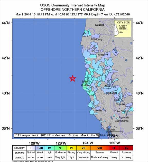
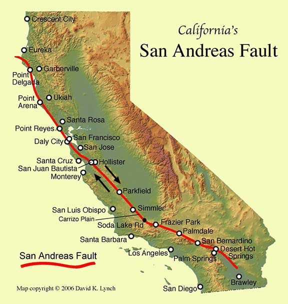
Magnitude 6.9 earthquake hits 50 miles west of Eureka NBC - March 10, 2014
A magnitude-6.9 earthquake struck off the coast of Northern California on Sunday night, the U.S. Geological Service reported. The epicenter was 48 miles west-northwest of Ferndale and 50 miles west of Eureka at a depth of 4.3 miles, the USGS said.
Strong Earthquake Shakes Northern California Live Science - March 10, 2014
An earthquake of preliminary magnitude 6.9 struck last night off the coast of northern California, according to the U.S. Geological Survey (USGS). Shaking was felt across the region as far south as the San Francisco Bay Area and as far north as Eugene, Oregon. There were no immediate reports of damage and no tsunami warnings were issued.
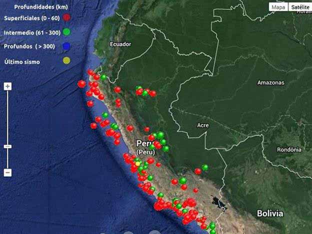
Magnitude 6.3 earthquake strikes northwestern Peru Reuters - March 25, 2014
A magnitude 6.3 earthquake struck northwestern Peru near its border with Ecuador on Saturday, the U.S. Geological Survey reported. Peru's National Civil Defense Institute (INDECI) said it had not received reports of serious damage or injuries, and authorities did not issue a tsunami alert. The quake struck at 6:51 p.m. local time (2351 GMT). Its epicenter was 28 miles south-southwest of Piura and it occurred at a depth of 6.1 miles, the USGS said. Brazilian construction company Odebrecht SA said its $700 million irrigation project in the area was unaffected. Still, the quake jolted the northern coastal region of Peru, with local media reporting that some people ran into the street after the tremor, fearing their homes could cave in. A witness on local radio RPP said the cross on the dome of a local church fell off. The quake was also felt in parts of neighboring Ecuador, according to Peruvian newspaper El Comercio.
Geologist warns that Peru's next earthquake could be a big one Peru This Week - March 25, 2014
Geologist Patricio Valderrama warns that Peru's latest tremors are a sign that the next earthquake will be a big one. There have been more than 50 tremors in Peru over the past few days, something which Peruvian geologist and volcanologist, Valderrama suggests could mean that a big earthquake is on its way. Valderrama says that there has been a long seismic silence in Tumbes, Piura, Lambayeque, Lima, and Tacna, with only small tremors taking place for a while.
"The small tremors don't release the energy of a bigger one. To release the same amount of energy required for one (an earthquake) of 8 (on the Richter scale), there would need to be30 (earthquakes) of 7," he said to '90 segundos matinal' of Frecuencia Latina. This means that the small quakes are a warning that later there will be a large scale earthquake in Peru that will affect all parts of the country, according to Peru.Com. "Our preparation must be constant," Valderrama added. A major concern is that some buildings, particularly in slum areas, will not be able to withstand a heavy earthquake. Valderrama said that with an earthquake registering 8 or more on the Richter scale, 70% of homes would collapse, potentially causing the deaths of thousands. While not wanting to be alarmist, Peru this Week would like to advise our readers in Peru to be prepared for an earthquake, with an emergency kit and escape route organized.
Puerto Rico Trench Wikipedia
Earthquakes and Cuba Local 10 News - March 10, 2014
Over the weekend, another earthquake hit near Corralillo, Cuba, approximately 110 miles east of Havana. This was the fourth earthquake since a magnitude 5.0 impacted the same area in January. The recent tremor was a magnitude 4.7, not exactly a major quake but enough to stir the curiosity. The truth is that Cuba is a seismically active area with a history of major earthquakes, some in excess of 7.0. However, most of Cuba's quakes are expected to occur along the southeastern coast.
In 1766, a major quake with a magnitude of 7.6 rocked the area near Santiago de Cuba. The recent quakes east of Havana are rare and have been felt all the way up into the Keys and parts of Broward County.To understand why this is happening, we have to zoom out and focus on the big picture. Hundreds of millions of years ago, the world's continents were one giant landmass known as Pangaea. Over time, a giant rift occurred tearing these continents apart. Have you ever noticed how the coastlines of the America's line up with the coastlines of Europe and Africa? This separation of landmasses continues today through the process of plate tectonics.
Our continents are sitting on plates that are constantly shifting and moving. For example, there is the North American plate, the African plate and so on. The most recent quakes in Cuba have occurred in a place where the North American plate borders the Caribbean plate. These two plates have been pressing against each other, creating the Cuban Fold and Thrust Belt. This type of fault is very rare but obviously capable of releasing energy. The Caribbean is a hotbed for seismic activity. In 2010, the catastrophic magnitude 7.0 quake that slammed Haiti killed more than 160,000 people. In 1995, the volcano on the island of Montserrat forced the permanent exodus from the capital, Plymouth. While northern Cuba is on the extreme northern fringe of the Caribbean seismic map, it serves as a reminder that this old planet of ours is constantly moving and changing. You and I are just going along for the ride.
Spike in Earthquakes? An 'Illusion' Raises New Questions NBC - April 21, 2014
Some of the best minds in earthquake science have been counting quakes and analyzing seismic waves to see if the largest in a string of recent quakes - the magnitude-8.2 tremor in Chile on April 1 - might have triggered others far, far away. Experts for years have known that the seismic waves from one quake can trigger a quake somewhere else - a process known as "dynamic triggering."
It is postulated that large earthquakes can have an influence outside of the immediate aftershock zone, and remotely trigger earthquakes at considerable distances. The further one gets from the initiating earthquake in both space and time, the more controversial is the association. Read more ...
Scientists puzzled by recent flurry of quakes in central Idaho EP- April 16, 2014
Three portable seismographs will be installed in the Challis area in central Idaho to help experts better understand a recent flurry of earthquakes. The U.S. Geological Survey has recorded a sequence of quakes rumbling the area, the largest of them being a 4.1-magnitude quake on Thursday, a 4.9 quake on Sunday and a 4.4 on Monday. Smaller quakes have also been recorded, including five on Monday ranging from 2.5 to 3.3 in magnitude.
Rare Earthquake Strikes Southern France Live Science - April 7, 2014
An earthquake of preliminary magnitude 5.0 shook southern France today (April 7), according to France's National Seismic Monitoring Network. The earthquake's epicenter was about 30 miles (50 kilometers) from the resort city of Nice and 69 miles (111 km) from Monaco. The quake originated 7 miles (11 km) deep and struck at 9:27 p.m. local time (19:27 UTC), the U.S. Geological Survey (USGS) reports. The USGS automated earthquake detection network calculated a preliminary magnitude of 4.7 for the temblor.
Earthquake Rattles Yellowstone National Park, No Damage Reported NBC - March 30, 2014
A 4.8 magnitude earthquake rocked Yellowstone National Park in Montana early Sunday, but there were no immediate reports of damage.
Yellowstone Supervolcano Crystalinks
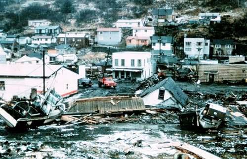
1964 Alaska earthquake Wikipedia
The 1964 Alaskan earthquake, also known as the Great Alaskan Earthquake and Good Friday Earthquake, was a megathrust earthquake that began at 5:36 P.M. AST on Good Friday, March 27, 1964. Across south-central Alaska, ground fissures, collapsing structures, and tsunamis resulting from the earthquake caused about 139 deaths. Lasting nearly three minutes, it was the most powerful recorded earthquake in U.S. and North American history, and the second most powerful ever measured by seismograph. It had a moment magnitude of 9.2, making it the second largest earthquake in recorded history - the largest being the 1960 Valdivia earthquake in Chile.
11 Facts About the 1964 Alaska Earthquake Live Science - March 27, 2014
1. Of the 131 people killed during the earthquake, 119 died in tsunamis. Most were killed by tsunamis triggered by underwater landslides, not by the earthquake-induced tsunami.
2. In Chenega, 25 of the village's 76 residents drowned in a tsunami. The only building that survived the wave intact was the schoolhouse, built 100 feet (30 meters) above sea level.
3. Several towns and villages were moved to safer ground after the tsunamis, including Seward, Valdez, Girdwood and Chenega.
4. The tallest tsunami wave height was 219 feet (67 m) in Shoup Bay in the Valdez Inlet. <> 5. The world rang like a bell for several weeks from the earthquake waves.
6. Seiche waves, sloshing of water back and forth in a small body of water like a boat harbor or swimming pool, were noted as far away as Louisiana, where a number of fishing boats were sunk. Oscillations in the height of water in wells were reported as far away as South Africa.
7. The earthquake initially had a magnitude of 8.5 on the Richter scale. The moment magnitude scale, a better measure of seismic power, has since superseded the Richter scale. The new size estimate is magnitude 9.2, the second most powerful ever recorded.
8. If the energy of a magnitude-5 earthquake is like snapping a single spaghetti strand, then a magnitude-9.2 earthquake releases enough energy to snap 800,000 spaghetti strands, according to the U.S. Geological Survey.
9. The damage totaled about $300 million in 1964 dollars ($2.3 billion in 2013 dollars).
10. Four out of five earthquakes in the United States occur in Alaska.
11. After the 1964 megathrust earthquake, three-quarters of the Aleutian subduction zone ruptured in a span of eight years. The subduction zone is 2,100 miles (3,300 kilometers) long.
How the 1964 Alaska Earthquake Shook Up Science Live Science - March 27, 2014
There were great horrors, but what many children remember is missing their supper. The earthquake struck at 5:36 p.m. Alaska Standard Time on Good Friday. When the first shaking hit, many parents were in the kitchen, fixing dinner. For more than 4 minutes, the earth buckled and lurched all across southern Alaska. Few people returned home to their meals that night. In Anchorage, the ground cracked open and giant fissures swallowed children whole, killing them in front of their siblings. Landslides launched tsunamis that swept away coastal villages before the shaking even ended. In Seward, spilled oil slicked the water and caught fire.
5.1 Earthquake felt in Los Angeles area of California BBC - March 17, 2014
The quake happened at about 21:10 local time on Friday (04:10 GMT on Saturday) and its epicentre was 1 mile (2km) east of the town of La Habra.
Magnitude 4.4 earthquake felt near Los Angeles BBC - March 17, 2014
The US Geological Survey (USGS) recorded the 4.4-magnitude quake 9km (5.6 miles) from the Los Angeles neighborhood of Westwood. It struck at 06:25 local time (13:25 GMT). No severe damage, injuries or deaths have been reported. A USGS spokeswoman said it was the strongest earthquake in Los Angeles since the last aftershocks from the 1994 Northridge quake.
What Caused the Los Angeles Earthquake Live Science - March 18, 2014
A small crack unzipped Monday (March 17) under the Santa Monica Mountains north of Los Angeles, waking millions of people with Southern California's largest earthquake in years. The fracture that caused the earthquake was not on a significant fault and is unlikely to be a new source of major earthquakes, said Caltech seismologist Egill Hauksson. (An earthquake is a sudden movement that releases stored energy on a fault.) Instead, the break likely is a bit player in California's tectonic drama, a minor crack in tortured crust being squeezed between two tectonic plates. There are thousands of small, unnamed faults in Southern California.
Magnitude 6.9 earthquake hits 50 miles west of Eureka NBC - March 10, 2014
A magnitude-6.9 earthquake struck off the coast of Northern California on Sunday night, the U.S. Geological Service reported. The epicenter was 48 miles west-northwest of Ferndale and 50 miles west of Eureka at a depth of 4.3 miles, the USGS said.
Strong Earthquake Shakes Northern California Live Science - March 10, 2014
An earthquake of preliminary magnitude 6.9 struck last night off the coast of northern California, according to the U.S. Geological Survey (USGS). Shaking was felt across the region as far south as the San Francisco Bay Area and as far north as Eugene, Oregon. There were no immediate reports of damage and no tsunami warnings were issued.
Earthquakes and Cuba Local 10 News - March 10, 2014
Over the weekend, another earthquake hit near Corralillo, Cuba, approximately 110 miles east of Havana. This was the fourth earthquake since a magnitude 5.0 impacted the same area in January. The recent tremor was a magnitude 4.7, not exactly a major quake but enough to stir the curiosity. The truth is that Cuba is a seismically active area with a history of major earthquakes, some in excess of 7.0. However, most of Cuba's quakes are expected to occur along the southeastern coast.
In 1766, a major quake with a magnitude of 7.6 rocked the area near Santiago de Cuba. The recent quakes east of Havana are rare and have been felt all the way up into the Keys and parts of Broward County.To understand why this is happening, we have to zoom out and focus on the big picture. Hundreds of millions of years ago, the world's continents were one giant landmass known as Pangaea. Over time, a giant rift occurred tearing these continents apart. Have you ever noticed how the coastlines of the America's line up with the coastlines of Europe and Africa? This separation of landmasses continues today through the process of plate tectonics.
Our continents are sitting on plates that are constantly shifting and moving. For example, there is the North American plate, the African plate and so on. The most recent quakes in Cuba have occurred in a place where the North American plate borders the Caribbean plate. These two plates have been pressing against each other, creating the Cuban Fold and Thrust Belt. This type of fault is very rare but obviously capable of releasing energy. The Caribbean is a hotbed for seismic activity. In 2010, the catastrophic magnitude 7.0 quake that slammed Haiti killed more than 160,000 people. In 1995, the volcano on the island of Montserrat forced the permanent exodus from the capital, Plymouth. While northern Cuba is on the extreme northern fringe of the Caribbean seismic map, it serves as a reminder that this old planet of ours is constantly moving and changing. You and I are just going along for the ride.
Images from CNN April 20, 2013
2013 Lushan earthquake Wikipedia
Italian Seismologists Could Get Four Years in Prison Live Science - September 27, 2012
2011 Sendai Earthquake and Tsunami
October 2010 Sumatra Earthquake and Tsunami Wikipedia
The country's most volatile volcano, Mount Merapi,
Both events fell along Indonesia's portion of the Pacific Ring of Fire, a
The quake was widely felt throughout the Western United States, and some Southern zones, and Northwest Mexico. The earthquake was the strongest to rock Southern California in at least 18 years (since the 1992 Landers earthquake (M 7.3)), if not longer: the next most recent comparable earthquake - the 1952 Kern County earthquake (M 7.3) - 58 years earlier. Each of these earthquakes had similar magnitudes, and were also felt across a large swath of North America.
The earthquake caused major damage in Port-au-Prince, Jacmel and other settlements in the region. Many notable landmark buildings were significantly damaged or destroyed, including the Presidential Palace, the National Assembly building, the Port-au-Prince Cathedral, and the main jail. Among those killed were Archbishop of Port-au-Prince Joseph Serge Miot, and opposition leader Micha Gaillard. The headquarters of the United Nations Stabilization Mission in Haiti (MINUSTAH), located in the capital, collapsed, killing many, including the Mission's Chief, Hedi Annabi.
Countries affected by the tsunami in the areas that were hit are American Samoa, Samoa and Tonga (Niuatoputapu) where more than 189 people were killed, especially children, most of them in Samoa. Large waves with no major damage were reported on the coasts of Fiji, the northern coast of New Zealand and Rarotonga in the Cook Islands. People took precautions in the low-lying atolls of Tokelau and moved to higher ground. Niue was reported as reasonably safe because it is high. There were no reports of high waves from Vanuatu, Kiribati, New Caledonia and the Solomon Islands.
Hello, Hot Stuff! New Hawaii Magma Source Found Live Science - February 4, 2014
Hawaii's Kilauea volcano conceals a deeply buried magma chamber beneath its East Rift Zone, where lava hasn't stopped streaming from the surface for 31 years, a new study reports. The chamber's molten mush, about 90 percent crystal and 10 percent magma, sits in oceanic crust about 5 to 7 miles (8 to 11 kilometers) beneath Kilauea's south slopes. The deep magma system may help lubricate the volcano's ongoing collapse into the ocean.
Earthquake lights linked to rift environments, subvertical faults PhysOrg - January 2, 2014
EQL take a variety of forms, including bright going spheres of light floating through the air - often purple or pink. Rare earthquake lights are more likely to occur on or near rift environments, where subvertical faults allow stress-induced electrical currents to flow rapidly to the surface. From the early days of seismology, the luminous phenomena associated with some earthquakes have intrigued scholars. Earthquake lights (EQL) appear before or during earthquakes, but rarely after.
Enormous earthquakes are missing from records BBC - December 12, 2013
The Earth could have been struck by many more huge earthquakes in its recent history than was previously thought, scientists say. Research suggests that half of all quakes measuring more than 8.5 in magnitude that hit in the 19th Century are missing from records. Scientists are scanning historical documents for the lost tremors
Earthquake scars Earth's gravity PhysOrg - December 4, 2013
ESA's GOCE satellite has revealed that the devastating Japanese earthquake of 2011 left its mark in Earth's gravity - yet another example of this extraordinary mission surpassing its original scope. GOCE mapped Earth's gravity with unrivaled precision for over four years, but nobody really expected the data to show changes over time. Now, careful analysis shows the effects of the 9.0 earthquake that struck east of Japan's Honshu Island on 11 March 2011 are clearly visible in GOCE's gravity data. Large earthquakes not only deform Earth's crust, but can also cause tiny changes in local gravity.
Seattle Football Fans Rock the House - and the Earth Live Science - December 3, 2013
Rowdy fans stomping and roaring when the Seattle Seahawks scored a touchdown last night (Dec. 2) shook the football stadium so hard that a nearby seismometer registered an "earthquake." It's not the first time the seismometer, which monitors earthquakes, picked up ground-shaking vibrations from Seahawks fans. Nearly three years ago, on Jan. 8., 2011, a 67-yard touchdown run now known as the "Beast Quake" resulted in a fan frenzy as powerful as a magnitude-2 temblor. A 1988 showdown between Louisiana State University and Auburn University also registered on LSU's local seismometer, leading ESPN to dub it the "Earthquake Game."
Deadly New Zealand Earthquakes Weakened Earth's Crust Live Science - November 25, 2013
A series of deadly earthquakes that shook New Zealand in 2010 and 2011 may have weakened a portion of Earth's crust, researchers say. New Zealand lies along the dangerous Ring of Fire - a narrow zone around the Pacific Ocean where about 90 percent of all the world's earthquakes, and 80 percent of the largest ones, strike. A devastating magnitude- 6.3 quake struck New Zealand's South Island in 2011. Centered very close to Christchurch, the country's second-largest city, it killed 185 people and damaged or destroyed 100,000 buildings. The earthquake was the costliest disaster to ever strike New Zealand, consuming about one-sixth of the country's gross domestic product.
Amazing Images of Pakistan's Earthquake Island Live Science - October 1, 2013
A new island, now called Zalzala Koh, emerged offshore of the town of Gwadar in Pakistan after a powerful Sept. 24 earthquake. Likely a form of mud volcano, the island rose from the seafloor hours after the magnitude-7.7 earthquake struck about 380 kilometers (230 miles) inland.
Norway's Weird Waves Traced to Japan Earthquake Live Science - August 16, 2013
On a calm winter's day in Norway two years ago, the sea suddenly started to boil and rise, sending freak waves rolling onto nearby shores and mystifying residents. Turns out, the massive magnitude-9.0 earthquake that shook Japan in 2011 also triggered these surprise seiche waves, a new study shows.
Early Warning Signs of Injection-Well Earthquakes Found Live Science - July 11, 2013
Two new studies of earthquakes near injection wells have seismologists using words rarely heard these days in earthquake science: prediction and warning. The research has also renewed calls for better seismic monitoring and reporting in regions experiencing man-made earthquakes. "Shale gas operations have completely changed our energy policy and people are injecting in places they've never injected before. If we're going to do this safely, we need to address the environmental issues, including protecting water supplies and earthquake risk.
Distant quakes 'can trigger wastewater-site temblors' BBC - July 11, 2013
Earthquakes can be triggered at the sites of wastewater injection by quakes on the other side of the world, research suggests. The injection of wastewater from underground operations such as oil drilling is known to increase local seismic activity. Now a study in Science suggests that waves from the most distant temblors can cause quakes at wastewater sites.
Fracking and energy exploration connected to earthquakes, say studies MSNBC - July 11, 2013
The rivers of water pumped into and out of the ground during the production of natural gas, oil and geothermal energy are causing the Earth to shake more frequently in areas where these industrial activities are soaring, according to a series of studies published today. While the gas extraction process known as hydraulic fracturing (aka "fracking") causes some small quakes, it's the disposal of wastewater following that process - and many others relating to energy production - that lead to the largest tremors.
Earthquakes Create Global-Scale GPS Errors Live Science - May 23, 2013
Twelve years of supersized earthquakes have contaminated GPS sites around the world, a new study finds. The Global Positioning System is a network of satellites and ground stations that provide location information anywhere on Earth. Except for spots in Australia, western Europe and the eastern tip of Canada, every GPS site on the ground underwent small but important shifts since 2000 because of big earthquakes, according to a study published May 6 in the Journal of Geophysical Research: Solid Earth. The research confirms that great earthquakes, those bigger than magnitude 8.0, can have far-reaching effects on the Earth's crust. And because GPS is critical for everything from calculating satellite orbits to sea level rise to earthquake hazards, scientists can't ignore these tiny zigs and zags, the researchers conclude.
Amid wreckage of China quake, the desperate search for survivors CNN - April 22, 2013
Families badly in need of food and water are living in makeshift shelters near the shattered remains of their houses in this area of the southwestern Chinese province of Sichuan where a strong earthquake struck over the weekend, killing at least 188 people.
What Caused The Deadly China Earthquake? Live Science - April 22, 2013
The strong earthquake that struck China's Sichuan province at 8:47 a.m. local time Saturday (April 20) probably hit along the same fault as the region's devastating 2008 earthquake, according to the U.S. Geological Survey. The epicenter of the magnitude-6.6 earthquake was likely on the Longmen Shan Fault, the USGS said in a report on the April 20 quake. It was centered at a relatively shallow 7.6 miles (12.3 kilometers) below the surface, similar to the 2008 temblor. The 2008 earthquake, a magnitude 7.9, killed more than 69,000 people and released 89 times more energy than yesterday's earthquake. The Longmen Shan Fault is actually a zone of tectonically-related thrust faults that mark the boundary between the high Tibetan Plateau and the Sichuan Basin lowlands. With each earthquake, a fault thrusts the plateau over the basin, shortening the distance between the two regions. The fault zone stretches more than 150 miles (240 km) along the base of the Longmen Shan Mountains. The mountain front is known for its amazingly steep rise - from 2,000 feet (600 meters) elevation in the basin to 21,325 feet (6,500 m) in the mountains, all in just 30 miles (50 km).
Breaking the Ice: Earthquakes Trigger Antarctic 'Icequakes' Live Science - April 22, 2013
When the world shakes, so does Antarctica's ice, according to a study presented here April 19 at the Seismological Society of America's annual meeting. Icequakes are vibrations in glaciers and ice sheets (the massive expanses of glacial ice that cover Antarctica and Greenland). From small creaks and groans to sudden slips equal to a magnitude-7 earthquake, the shaking signals movement in the ice. Scientists discovered that big earthquakes, including Japan's 2011 Tohoku quake and Chile's 2010 Maule temblor, set off icequakes across Antarctica, just as they triggered earthquakes on land.
6.0-Magnitude Earthquake Strikes Off Kuril Islands Live Science - April 19, 2013
Earthquakes of this size are considered major and can cause significant damage, especially with poorly built structures. Even well designed buildings can be damaged or, in some cases, destroyed depending on the severity of the quake and a building's proximity to the epicenter. Earthquakes of this size are sometimes followed by significant aftershocks.
Mine Disaster - Earthquakes Shed New Light on Utah Collapse Live Science - April 19, 2013
One of Utah's deadliest mine disasters may have brought down the entire Crandall Canyon coal mine, according to a new seismic study presented today (April 19) at the Seismological Society of America's annual meeting in Salt Lake City. At Crandall Canyon, a room carved from coal collapsed 1,500 feet (457 meters) below the surface on Aug. 6, 2007, trapping six workers. A tunnel collapse on Aug. 16 killed three rescuers digging toward the suspected location of the miners. The bodies of the six miners were never recovered. With new analysis techniques, researchers at the University of Utah identified up to 2,000 tiny, previously unrecognized earthquakes before, during and after the coal mine collapse.
Earthquakes Are East Coast's Biggest Tsunami Threat Live Science - April 19, 2013
The U.S. East Coast's biggest tsunami threat lurks just offshore, according to research presented today (April 19) at the Seismological Society of America's annual meeting in Salt Lake City. Recent earthquake swarms off the Massachusetts coast highlight the threat of tsunamis from nearby earthquakes, rather than faraway islands, said John Ebel, a seismologist at Boston College. The geologic setting of the quakes off the Northeast appears similar to that of a magnitude-7.3 earthquake that struck in the Grand Banks off Newfoundland in 1929, Ebel said. The resulting 32-foot (10 meters) tsunami swamped southern Newfoundland and triggered underwater landslides that severed transatlantic telephone cables.
Hurricane Sandy lit up seismometers across US MSNBC - April 20, 2013
Hurricane Sandy's fateful left turn toward the mid-Atlantic Coast in October last year lit up earthquake monitors all the way to Seattle, according to results presented at the Seismological Society of America's annual meeting Thursday. When Hurricane Sandy veered on Oct. 29, the sudden increase in crashing ocean waves sent rumbles through the Earth detectable on seismometers. The wave-on-wave collisions created what are called standing waves, doubling the energy directed at the seafloor, scientists reported today. The ocean gave the seafloor a little shove, sending seismic waves through the Earth.
Quite a Jolt: Earthquakes Heralded Opening of Sinkhole Live Science - April 17, 2013
Earthquakes signaled the opening of a giant toxic sinkhole in southeastern Louisiana last year, researchers reported here today at the Seismological Society of America's annual meeting. Strong shaking first rattled residents of Bayou Corne on June 8 and July 3 in 2012, prompting officials to install earthquake monitors near the small town. After July 14, seismometers detected 10 to 12 sharp tremors of about magnitude 2.5 jolting the region daily, said Steve Horton, a seismologist at the University of Memphis and lead study author.
Salt Lake City Could See Bigger Earthquakes Live Science - April 17, 2013
Two faults bounding Utah's biggest city may combine to produce especially powerful earthquakes, geologists will report in Salt Lake City today (April 17) at the annual meeting of the Seismological Society of America. Utah's biggest earthquake fault runs east of Salt Lake City, at the base of the steep Wasatch Mountains. About 75 percent of the state's population lives near the 240-mile-long (385 kilometers) Wasatch Fault, according to the Utah Geological Survey. Its last big earthquake hit in 1600, 247 years before Mormon settlers arrived.
Major earthquake strikes south-east Iran BBC - April 16, 2013
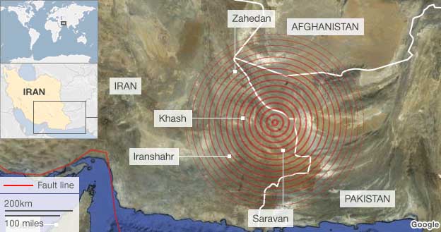
Iran has been struck by its most powerful earthquake for nearly 40 years, with tremors felt across Pakistan, India and the Middle East. The epicentre of the 7.8 magnitude quake was near the south-east city of Khash, close to the Pakistani border, the US Geological Survey said. Offices were evacuated in Abu Dhabi and buildings swayed in Delhi, India.
Series of earthquakes shakes Oklahoma MSNBC - April 16, 2013
A magnitude-4.3 earthquake shook Oklahoma early Tuesday, the United States Geological Survey reported. The quake struck at 12:56 a.m. local time (1:56 a.m. ET) around 30 miles northeast of Oklahoma City. It was measured at a depth of 3.1 miles, the USGS said.
What Caused Iran's 6.3 Deadly Earthquake? Live Science - April 9, 2013
Crashing continents caused today's deadly earthquake in Iran, which killed dozens. The magnitude-6.3 Iran earthquake hit in the southern Zagros Mountains, a stunning range that marks the boundary between the Arabian and Eurasian tectonic plates. The Arabian plate is grinding northward at about 0.4 inches (10 millimeters) a year, pushing the boot-shaped Arabian peninsula into the Eurasian plate, which covers most of Europe and Asia.
Japan quake 'heard at edge of space' BBC - March 10, 2013
The great Tohoku earthquake in Japan two years ago was so big its effects were even felt at the edge of space. Scientists say the Magnitude 9.0 tremor on 11 March 2011 sent a ripple of sound through the atmosphere that was picked up by the Goce satellite. Its super-sensitive instrumentation was able to detect the disturbance as it passed through the thin wisps of air still present 255km above the Earth.
6.3-Magnitude Earthquake Strikes Off California Live Science - December 14, 2012
The earthquake originated 7 miles (11.3 km) deep and struck at 2:36 a.m. local time. The temblor's epicenter was 172 miles (277 km) southwest of Coronado, Calif., (just outside of downtown San Diego) and 163 miles (263 km) south-southwest of Santa Catalina Island - also hitting Newport Beach, Santa Ana, Temecula and Long Beach. Though Southern California experiences frequent earthquakes along the San Andreas and associated faults, the spot where today's quake struck has not seen any temblors greater than magnitude 6.0 in the past 40 years, according to the USGS. No tsunami warning was immediately issued. There also were no reports of damage or injuries on the mainland.
2012 Haida Gwaii Earthquake Wikipedia
The 2012 Haida Gwaii earthquake was a 7.8 Mw, earthquake that occurred just after 8:04 p.m. PDT on October 27, 2012. This was the second largest Canadian earthquake ever recorded by a seismometer, after the 1949 Queen Charlotte Islands earthquake, about 135 kilometres (84 mi) away. A tsunami warning was issued for the North American Coast from the Alaskan Panhandle to Vancouver Island, but later limited to the North Coast region of British Columbia. There were 94 aftershocks of magnitude 4.0 or greater lasting until November 7, as recorded by the USGS.
Huge Earthquake Triggered Other Quakes Worldwide Live Science - September 27, 2012
On April 11, a massive magnitude 8.6 earthquake shook the floor of the Indian Ocean off Sumatra. It wasn't just unusual because of its size - the 10th largest quake in the last century - it also set off a series of quakes around the world for up to six days afterward, according to a study published today (Sept. 26) in the journal Nature. "Until now, we seismologists have always said, 'Don't worry about distant earthquakes triggering local quakes,'" said Roland Burgmann, an earth and planetary scientist at UC Berkeley, in a statement. "This study now says that, while it is very rare - it may only happen every few decades - it is a real possibility if the right kind of earthquake happens." The study found that some quakes were triggered within a few hours, while in other places the seismic waves from the Sumatran quake primed temblors to happen for up to six days later.
Weird 2012 Quake Signals Tectonic Plate Birth Live Science - September 27, 2012
On the afternoon of April 11, 2012, one of the most powerful earthquakes ever recorded - and now revealed to be among the weirdest - struck in the Indian Ocean, off the coast of Sumatra. It's a region all too familiar with geological catastrophe. Eight years earlier, in December 2004, the third largest earthquake on record had ripped through a nearby region of the ocean floor. The magnitude-9.1 earthquake and the monstrous tsunami that soon followed killed more than 227,000 people in 14 countries, So when a magnitude-8.7 earthquake (some put the magnitude at 8.6) shook the Indonesian island on that Wednesday afternoon earlier this year, many expected the worst. Yet, no monster wave appeared. A wave did come ashore, but it was a miniature tsunami, just 12 inches (31 centimeters) high.
April Sumatra quakes signal Indian ocean plate break-up BBC - September 27, 2012
The sequence of huge earthquakes that struck off the coast of Sumatra in April may signal the creation of a new tectonic plate boundary. They say their analysis of the tremors - the biggest was a magnitude 8.7 - suggests major changes are taking place on the ocean floor that will eventually split the Indo-Australian plate in two.
Six Italian scientists and one government official could see four-year prison terms for manslaughter for allegedly downplaying the risk of an earthquake in the town of L'Aquila, Italy, in 2009.
Watch how Costa Rica quake vibrations rattled beneath US MSNBC - September 5, 2012
A new animation shows the shockwave from the 7.6 magnitude earthquake that struck Costa Rica Wednesday morning arriving and reverberating through the ground beneath the United States. The visualization was made by scientists at Incorporated Research Institutions for Seismology (IRIS) and shows the Earth slowly moving up and down. Red spots show seismometers moving upward; the darker the hue, the higher they are moving up. The opposite goes for blue. The visualization shows how earthquakes create waves of motion through the Earth's crust, just as a pebble tossed into a pond creates a ripple. "But in this case, the pond is North America," said John Taber, head of outreach for IRIS.
Watch Costa Rica Quake Vibrations Hit US Live Science - September 6, 2012
A new animation shows the shockwave from the 7.6 magnitude earthquake that struck Costa Rica this morning (Sept. 5) arriving and reverberating through the ground beneath the United States. The visualization was made by scientists at Incorporated Research Institutions for Seismology (IRIS) and shows the Earth slowly moving up and down. Red spots show seismometers moving upward; the darker the hue, the higher they are moving up. The opposite goes for blue. The visualization shows how earthquakes create waves of motion through the Earth's crust, just as a pebble tossed into a pond creates a ripple.
Earthquakes Reveal Magma Plumbing Beneath Volcanoes Live Science - July 20, 2012
A helicopter battled near-hurricane-force winds as a team of seismologists fought its way through a treacherous mountain pass to reach the Alaska Peninsula's Katmai area. Their goal: to install a network of seismometers around the Katmai Volcanoes, the source of the largest volcanic eruption since Indonesia's Mount Tambora in 1815. Four years and mounds of data later, the team is beginning to understand the plumbing system beneath that group of volcanoes, including the magma source for the 1912 Novarupta eruption, which spewed 3 cubic miles (12 cubic kilometers) of magma and dwarfed the 1980 Mount St. Helens eruption 30 times over.
 Stunning Map Reveals World's Earthquakes Since 1898 Live Science - June 29, 2012
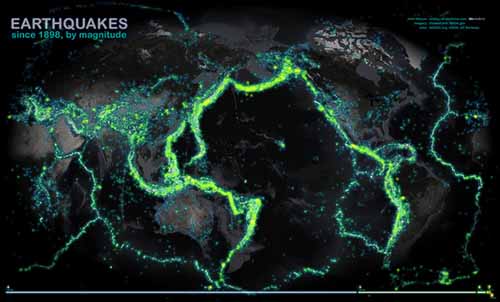
If you've ever wondered where - and why - earthquakes happen the most, look no further than a new map, which plots more than a century's worth of nearly every recorded earthquake strong enough to at least rattle the bookshelves. The map shows earthquakes of magnitude 4.0 or greater since 1898; each is marked in a lightning-bug hue that glows brighter with increasing magnitude.
Are 4 Big Earthquakes in 2 Days Connected? Live Science - April 12, 2012
The 8.6-magnitude earthquake that hit off the coast of Sumatra, Indonesia, yesterday (April 11) was followed by several decent-size shakes along the west coast of North America, but researchers can't say for certain whether all the temblors were related.
Oregon: New massive fault line found on Mount Hood MSNBC - August 30, 2011
Geologists think Mount Hood is sitting on shaky ground. The Oregonian first reported that scientists have discovered a previously undetected - and active - fault zone on the mountain. Scientists said the faults could also prove dangerous. The fault zone stretches about 20 miles from the northern flank of Mount Hood to the Columbia River. Hidden by trees and dense vegetation, it had gone unnoticed. Oregon state scientists discovered the fault line using aircraft equipped with LIDAR - a high-tech laser scanning mapping system. Oregon State Department of Geology Chief Scientist Ian Mayden helped map out the faults and believes they likely make up one massive fault that at one point in history ruptured, causing the earth to break apart some six feet.
7.1 magnitude earthquake strikes off Alaska MSNBC - September 2, 2011
A 7.1 magnitude earthquake struck Friday in the Aleutian Islands off Alaska, the U.S. Geological Survey reported, prompting a brief tsunami warning for a portion of Alaska's coast.
The U.S. Geological Survey said the earthquake struck in the waters at about 6:55 a.m. ET. There were no reports of injuries or damage, according to Alaska's KTUU.com.
New Hidden Quake Fault Found in California Live Science - June 16, 2011
Scientists with the U.S. Army Corps of Engineers were inspecting the Martis Creek Dam, which sits just outside Truckee, Calif., and about 35 miles upstream from Reno. It is one of 10 dams in the United States that has urgent and compelling safety concerns, according to the Corps, which owns the dam. Data from the most recent evaluation revealed that, not only does the dam have significant leakage, it also lies in close proximity to not two, but three fault zones.
Scientists find odd twist in slow 'earthquakes': Tremor running backwards PhysOrg - May 23, 2011
Earthquake scientists trying to unravel the mysteries of an unfelt, weeks-long seismic phenomenon called episodic tremor and slip have discovered a strange twist. The tremor can suddenly reverse direction and travel back through areas of the fault that it had ruptured in preceding days, and do so 20 to 40 times faster than the original fault rupture.
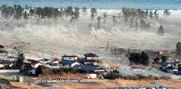
Scientists find increase in microearthquakes after Chilean quake PhysOrg - February 25, 2011
By studying seismographs from the earthquake that hit Chile last February, earth scientists at the Georgia Institute of Technology have found a statistically significant increase of micro-earthquakes in central California in the first few hours after the main shock. The observation provides an additional support that seismic waves from distant earthquakes could also trigger seismic events on the other side of the earth. The results may be found online in the journal Geophysical Research Letters.
Indonesia Earthquake, Tsunami, Mt. Merapi Erupts
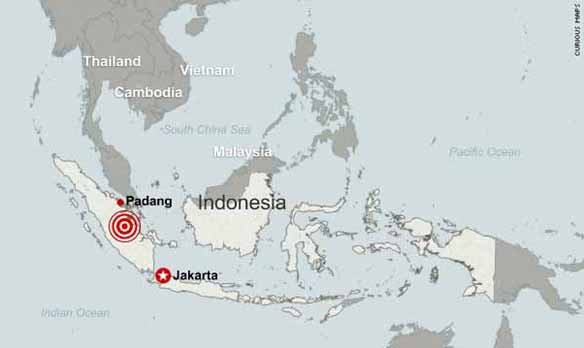
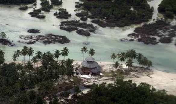
800 miles (1,300 kilometers) to the east, erupted.
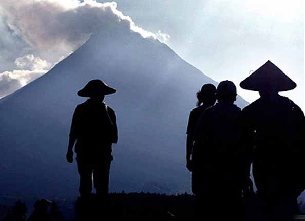
series of fault lines that are prone to earthquakes and volcanic activity
stretching from the Western Hemisphere through Japan and Southeast Asia.
Indonesia's Explosive Geology Explained Live Science - October 26, 2010
Indonesia is a dangerous country to call home. Precariously located above the grinding and mashing of several tectonic plates, and ringed by a chain of fire-breathing volcanoes, the country's islands are located in one of the most volatile regions in the world. The eruption of a volcano and the shaking of a tsunami-generating earthquake this week is just one reminder of Indonesia's fiery foundation.
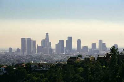
Big quakes more frequent than thought on San Andreas fault PhysOrg - August 21, 2010
Earthquakes have rocked the powerful San Andreas fault that splits California far more often than previously thought, according to UC Irvine and Arizona State University researchers who have charted temblors there stretching back 700 years. The dreaded "Big One" could be just around the corner.
Earthquake Moved California City 31 Inches Live Science - June 24, 2010
Quake physically moved Calexico 2.5 feet south MSNBC - June 24, 2010
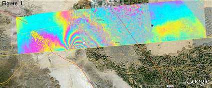
Odds 1-in-3 for Northwest Mega-Quake Within 50 Years Live Science - May 24, 2010
A major earthquake, similar to what devastated Chile and Haiti, has more than a one-in-three chance of striking the U.S. Pacific Northwest within the next 50 years, scientists say. Earlier estimates put the chance of such quakes at just once every 500 years. But new analyses by Oregon State University marine geologist Chris Goldfinger and his colleagues have revealed a more complex picture of the Cascadia Subduction zone, where the ocean floor steadily slips below the North American Plate - and where the region's earthquakes originate. They found that Cascadia represents at least four separate segments, rather than one big subduction zone. Mega-quakes of magnitude-9 or greater occur less frequently in the northern segment and can rupture the entire fault, even as magnitude-8 earthquakes strike more often in the southern segment.
April 4, 2010 Baja California 7.2 earthquake Wikipedia
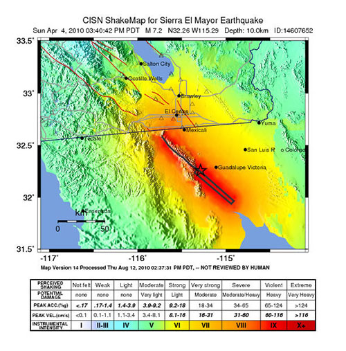
The 2010 Baja California earthquake (also known as 2010 Easter earthquake, 2010 Sierra El Mayor earthquake, or 2010 El Mayor - Cucapah earthquake) was an earthquake of 7.2 magnitude on the moment magnitude scale. It started 26 kilometers (16 mi) south of Guadalupe Victoria, Baja California, Mexico, at a depth of 10 km (6.2 mi).[3] It occurred at 3:40:41 pm Pacific Daylight Time (PDT) (22:40:41 UTC) on Easter Sunday, April 4, 2010, and it is said to have lasted about a minute and a half. The strongest shaking was felt in the ejido of Alberto Oviedo Mota, municipality of Mexicali, at Mercalli intensity scale VIII (Severe). In Mexicali, Calexico and Guadalupe Victoria it rated VII (Very Strong), while in Ensenada and Tijuana it measured VI (Strong). Most of the damage in this earthquake occurred in the twin cities of Mexicali and Calexico on the Mexico-United States border. Four people were killed and 100 people were injured.
Thousands of Quakes Strike Glaciers Every Day Live Science - April 3, 2010
Up to thousands of "icequakes" may shake a glacier a day, rumblings that could shed light on how climate is changing.
Just as volcanoes involve magma interacting with rock, so too do glaciers often involve interplays between water and ice. As such, giant events within glaciers can occur, with icequakes in Antarctica known to reach the force of a magnitude 7 earthquake.
To learn more about icequakes, scientists in Alaska used equipment and techniques normally employed for monitoring seismic events to investigate the Bering Glacier, which flows from the St. Elias mountain range to the south-central coast of Alaska. Ice in this temperate glacier is near its melting point, leading to a history of dramatic surges.
Toads can 'predict earthquakes' and seismic activity BBC - March 31, 2010
Common toads appear to be able to sense an impending earthquake and will flee their colony days before the seismic activity strikes.
The evidence comes from a population of toads which left their breeding colony three days before an earthquake that struck L'Aquila in Italy in 2009. How toads sensed the quake is unclear, but most breeding pairs and males fled. They reacted despite the colony being 74km from the quake's epicentre, say biologists in the Journal of Zoology. It is hard to objectively and quantifiably study how animals respond to seismic activity, in part because earthquakes are rare and unpredictable. Some studies have been done on how domestic animals respond, but measuring the response of wild animals is more difficult.
Quake Moved Chilean City 10 Feet Live Science - March 9, 2010
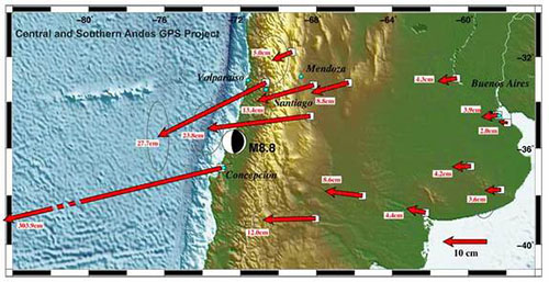
The massive 8.8 magnitude earthquake that struck Chile more than a week ago moved the city of Concepci�n at least 10 feet (3 meters) to the west, seismological measurements indicate. The violent temblor the fifth most powerful quake ever measured shifted other parts of South America as well, from the Falkland Islands (located just east of the southern tip of South America) to Fortaleza, Brazil, situated on that country's northern coast. The quake occurred off the coast of the Maule region of Chile in one of Earth's seismic hotspots where the Nazca tectonic plate is squeezed under, or subducted below, the neighboring South American plate. Tension builds up as the plates move against each other, and earthquakes such as the one that struck Chile on Feb. 27 relieve these pent-up stresses.
Researchers show how far South American cities moved in quake PhysOrg - March 8, 2010
The massive magnitude 8.8 earthquake that struck the west coast of Chile last month moved the entire city of Concepcion at least 10 feet to the west, and shifted other parts of South America as far apart as the Falkland Islands and Fortaleza, Brazil.
A Disastrous Year: 2010 Death Toll Already Abnormally High Live Science - March 11, 2010
Just a few months into 2010, and Mother Nature has delivered a slew of costly and deadly natural disasters. From the catastrophic Haiti and Chilean earthquakes to the U.S. blizzard that descended on Washington, D.C., last month, which was mostly just inconvenient by comparison, 2010 is already above average in terms of natural-disaster casualties. In comparison to previous years, the number of casualties from natural disasters in 2010, which is already well above 200,000, is outside the norm. Yet as in other disastrous years, the high toll this year is due largely to a single event. Over the decade from 2000 to the end of 2009, the yearly average was 78,000, according to the United Nations International Strategy for Disaster Reduction (ISDR). For the 1990s, the average was 43,000, and the 1980s was 75,000. Disaster experts say the rise in tragedy is at least partly due to increases in urban populations.
Why the Chile Earthquake Aftershock Was So Big Live Science - March 11, 2010
The whopping 7.2-magnitude aftershock that rattled Chile again today is nothing unusual following such a large original earthquake, scientists say. The aftershock, which struck at about 11:40 am local time, may sound surprisingly strong, given that it is bigger than the original earthquake that decimated Haiti in January, but it wasn't unexpected to scientists, said Don Blakeman, a geophysicist with the United States Geological Survey. The 8.8-magnitude earthquake that struck off the coast of the Maule region of Chile on Feb. 27 was one of the strongest ever recorded. After such a strong quake, aftershocks that are themselves substantial are par for the course.
7.0 Earthquake in Haiti Wikipedia - January 12, 2010
The 2010 Haiti earthquake was a catastrophic magnitude 7.0 Mw earthquake, with an epicenter near the town of Leogane (Ouest Department), approximately 25 km (16 miles) west of Port-au-Prince, Haiti's capital. The earthquake occurred at 16:53 local time (21:53 UTC) on Tuesday, 12 January 2010. By 24 January, at least 52 aftershocks measuring 4.5 or greater had been recorded.[9] An estimated three million people were affected by the quake. Death toll estimates range from 100,000 [6] to 159,000 [5] to Haitian government figures from 220,000 to 316,000 that have been widely characterized as deliberately inflated by the Haitian government. The government of Haiti estimated that 250,000 residences and 30,000 commercial buildings had collapsed or were severely damaged.
Haiti quake: The worst of places for a big tremor BBC - January 13, 2010
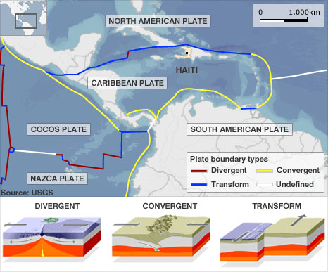
It was immediately obvious that Tuesday's quake in Haiti would be an appalling natural disaster.
This was a large tremor centred on an impoverished country with little recent experience or preparedness for such an event.
The buildings in the quake zones of major industrialised nations sit on damping systems that allow them to ride out tremors that not only shake them back and forth but also twist them in the same movement. The simplest concrete structures in the capital of Port-au-Prince will have crumpled under the same strain. Seismometers recorded a preliminary magnitude of 7.0 at 1653 local time (2153 GMT). The epicentre's proximity to Port-au-Prince - 15km (10 miles) - and the focus (or depth) of just 8km (5 miles) will have ensured the destructive forces were at their most intense.
Tremors Between Slip Events: More Evidence of Great Quake Danger to Seattle Science Daily - December 16, 2009
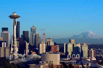
For most of a decade, scientists have documented unfelt and slow-moving seismic events, called episodic tremor and slip, showing up in regular cycles under the Olympic Peninsula of Washington state and Vancouver Island in British Columbia. They last three weeks on average and release as much energy as a magnitude 6.5 earthquake.
September 2009 Sumatra earthquake Wikipedia
The September 2009 Sumatra earthquake occurred just off the southern coast of Sumatra, Indonesia. The major shock hit at 17:16:10 local time on September 30, 2009 (10:16:10 UTC) and had a moment magnitude of 7.9. The epicenter was 45 kilometres (28 mi) west-northwest of Padang, Sumatra, and 220 kilometres (140 mi) southwest of Pekanbaru, Sumatra. Early death-toll estimates extended beyond 1300. Government reports have to date confirmed 1,115 dead, 1,214 severely injured and 1,688 slightly injured. The most deaths occurred in the areas of Padang Pariaman (675), Padang (313), Agam (80) and Pariaman (37). In addition, around 135,000 houses were severely damaged, 65,000 houses were moderately damaged and 79,000 houses were slightly damaged. An estimated 250,000 families (1,250,000 people) have been affected by the earthquake through the total or partial loss of their homes and livelihoods.
2009 Samoa Earthquake Wikipedia

The 2009 Samoa earthquake was an 8.1 Mw submarine earthquake that took place in the Samoan Islands region at 06:48:11 local time on 29 September 2009 (17:48:11 UTC, 29 September). At a magnitude of 8.1, it was the largest earthquake of 2009.
A tsunami was generated which caused substantial damage and loss of life in Samoa, American Samoa, and Tonga. The Pacific Tsunami Warning Center recorded a 3-inch (76 mm) rise in sea levels near the epicenter, and New Zealand scientists determined that the waves measured 14 metres (46 ft) at their highest on the Samoan coast. The quake occurred on the outer rise of the Kermadec-Tonga Subduction Zone. This is part of the Pacific Ring of Fire, where tectonic plates in the Earth's lithosphere meet and earthquakes and volcanic activity are common.