
The Mediterranean Isn't Safe: Scientists Warn of Inevitable Tsunami SciTech Daily - March 30, 2026
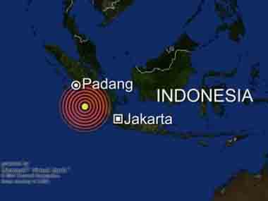
The Mediterranean is often viewed as a low-risk region for tsunamis, yet historical records and recent modeling suggest otherwise, with multiple events already impacting the French Riviera
NASA Satellite Captures First-Ever High-Res View of a Giant Pacific Tsunami Science Alert - December 3, 2025

First Detailed Look at a Tsunami From Space Reveals Unexpected Feature - SWOT data suggest the tsunami broke up, forming a relatively large leading wave followed by smaller trailing waves SciTech Daily - December 3, 2025

2025 Kamchatka Peninsula Earthquake Wikipedia
How a Giant Earthquake Triggered a Surprisingly Small Tsunami Science Alert - July 30, 2025
Why the Pacific tsunami was smaller than expected: A geologist explains PhysOrg - July 31, 2025
Tsunami waves hit US shores after 8.8 magnitude quake strikes Russia's far east - 6th most powerful ever recorded CNN - July 30, 2025
The region is known for seismic activity due to its location in the Pacific Ring of Fire - a belt in the Pacific where the world's most active volcanoes are located.
Russian volcano explodes in 'powerful' eruption, likely intensified by 8.8 magnitude earthquake
Aftershocks are expected to continue for some time, though decreasing in frequency and magnitude.
Climate change and natural disasters continue to accelerate exponentially as we move to closure. This summer has seen unprecedented global flooding and extreme heat. All of the tectonic plates are broken or fractured highlighted with the Pacific Plate.
The 8.8 pacific earthquake could have affected this predicted event ... Undersea Volcano Off The US West Coast Predicted To Erupt In 2025
Greenland's mega tsunamis: First direct observation of the trapped waves that shook the world PhysOrg - June 3, 2025

In September 2023, a bizarre global seismic signal was observed which appeared every 90 seconds over nine days - and was then repeated a month later. Almost a year later, two scientific studies proposed that the cause of these seismic anomalies were two mega tsunamis which were triggered in a remote East Greenland fjord by two major landslides which occurred due to warming of an unnamed glacier.
The waves were thought to have become trapped in the fjord system, forming standing waves (or seiches) that undulated back and forth, causing the mystery signals. However, up to now no observations of these seiches existed to confirm this theory. Even a Danish military vessel which visited the fjord three days into the first seismic event did not observe the wave which was shaking Earth. In a new study, Oxford researchers used novel analysis techniques to interpret satellite altimetry data. This measures the height of the Earth's surface (including the ocean) by recording how long it takes for a radar pulse to travel from a satellite to the surface and back again.
A 2.6-Million-Pound Rock Thrown Inland by a Monster Wave Daily Galaxy - June 1, 2025

Hidden in the dense greenery of southern Tongatapu, a limestone monolith named Maka Lahi - meaning 'Big Rock' in Tongan - has quietly testified to a prehistoric cataclysm for thousands of years. Weighing an estimated 1,180 tons and resting over 200 meters from the sea, this colossal boulder has now been confirmed by researchers as evidence of an ancient and immensely powerful tsunami that struck the region approximately 6,900 years ago.
Skyscraper Tsunami Unleashed by Seismic Anomaly Never Seen Before Science Alert - September 13, 2024
Earthquake scientists detected an unusual signal on monitoring stations used to detect seismic activity during September 2023. We saw it on sensors everywhere, from the Arctic to Antarctica. The signal was unlike any previously recorded. Instead of the frequency-rich rumble typical of earthquakes, this was a monotonous hum, containing only a single vibration frequency. Even more puzzling was that the signal kept going for nine days. Initially classified as a "USO" - an unidentified seismic object - the source of the signal was eventually traced back to a massive landslide in Greenland's remote Dickson Fjord. A staggering volume of rock and ice, enough to fill 10,000 Olympic-sized swimming pools, plunged into the fjord, triggering a 200-meter-high mega-tsunami and a phenomenon known as a seiche: a wave in the icy fjord that continued to slosh back and forth, some 10,000 times over nine days. To put the tsunami in context, that 200-metre wave was double the height of the tower that houses Big Ben in London and many times higher than anything recorded after massive undersea earthquakes in Indonesia in 2004 (the Boxing Day tsunami) or Japan in 2011 (the tsunami which hit Fukushima nuclear plant).
Scientists now know the 700-mile fault called the Cascadia Subduction Zone, 100 miles off the coast of Northern California stretching north to Vancouver Island, could trigger a 9.0 magnitude earthquake followed by a tsunami, which is exactly what happened in Japan 2011.
Lake tsunamis are a thing too, and they can be just as devastating - here's everything you need to know about them IFL Science - May 3, 2024

They happen when the sudden displacement of large volumes of water causes waves to form. The phenomenon is becoming increasingly common in places like Alaska and British Columbia, as well as other regions with mountain glaciers. Like ocean tsunamis, which are usually caused by an earthquake below or near the sea floor, lake tsunamis can also result from seismic activity. When lakes lie on or near a fault line, earthquakes can disrupt the lake bed and displace large amounts of water as a tsunami.
Hidden magnitude-8.2 earthquake was hidden within the magnitude 7.2 earthquake - and the source of mysterious 2021 global tsunami PhysOrg - February 8, 2022
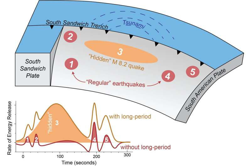
Scientists have uncovered the source of a mysterious 2021 tsunami that sent waves around the globe. In August 2021, a magnitude 7.5 earthquake hit near the South Sandwich Islands, creating a tsunami that rippled around the globe. The epicenter was 47 kilometers below the Earth's surface - too deep to initiate a tsunami - and the rupture was nearly 400 kilometers long, which should have generated a much larger earthquake. Seismologists were puzzled and sought to understand what really happened that day in the remote South Atlantic.
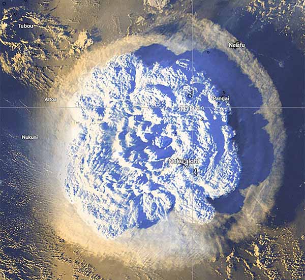
2022 Hunga Tonga Eruption and Tsunami Wikipedia
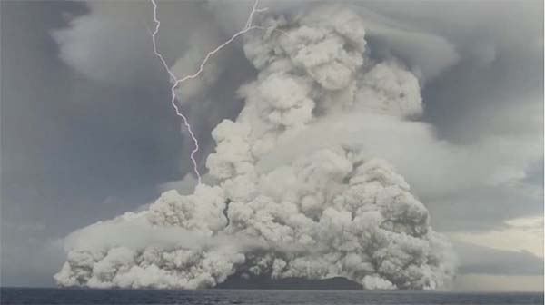
Tsunami Waves Over 4 Feet High Hit Pacific Coast after Major Eruption near Tonga
Waves between 1 and 4 feet were reported from California to Alaska Saturday after a tsunami advisory was issued because of a volcanic eruption in the South Pacific. The advisory was issued for Hawaii and the U.S. Pacific Coast including California, Oregon, Washington and parts of Alaska early Saturday morning after the undersea volcano erupted near the island nation of Tonga. A wave of 4.3 feet was reported in Port San Luis California, according to the National Weather Service. Large waves were also reported in King Cove, Alaska, La Push, Washington, and several other locations. Two people were transported to the hospital after being swept into the water Saturday afternoon at San Gregorio State Beach, according to local fire officials. One was taken by helicopter.
Tsunamis' magnetic fields are detectable before sea level change PhysOrg - December 22, 2021
A new study finds the magnetic field generated by a tsunami can be detected a few minutes earlier than changes in sea level and could improve warnings of these giant waves.
Nearly 300 Years Ago, a Tsunami Hit The Coast of Chile, But Nobody Found It Until Now Science Alert - December 13, 2021
The south-central coast of Chile could be more vulnerable to tsunamis than the historical record suggests. Geological research among the tidal marshes of Chaihuin has now revealed the fallout of a long, high wall of water that struck land in 1737. Written documents from the time, however, describe no such wave.
Watch: Moment Tsunami Flows Through Turkey Town After Earthquake Weather.com - November 3, 2020
Videos: A powerful earthquake has struck off Turkey's Aegean coast and north of the Greek island of Samos, destroying homes and killing at least 22 people. BBC - October 31, 2020 - An earthquake off the coast of Turkey killed at least 62 people and injured more than 900. Rescuers continued to dig through tons of rubble for survivors Izmir, the country's third largest city.
Powerful 7.0 earthquake jolts Turkey and Greece, killing at least 27 CNN - October 31, 2020
The earthquake sent buildings crashing down and triggering what authorities have called a "mini tsunami."
December 22, 2018 Sunda Strait Volcano Tsunami - North of Christmas Island Wikipedia
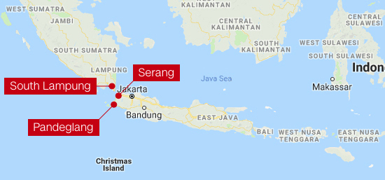
A volcano tsunami happened without warning after Anak Krakatau's erupted caused by an undersea landslide. Lying on the Ring of Fire, Indonesia experiences a high frequency of earthquakes and is home to 127 active volcanoes. The catastrophic 2004 Indian Ocean 9.3 earthquake and tsunami happened around the same time of year, occurring on December 26 (Boxing Day), but causing more widespread damage throughout the rim of the Indian Ocean, with countries as far afield as Thailand and Sri Lanka being affected.
Emergency Alert Test Sent Nationwide

Feds send first emergency message test to cell phones CNN - October 4, 2018
If you have a cell phone, it probably buzzed and beeped loudly Wednesday afternoon October 3, 2018 around 2:18 p.m. ET. "Presidential Alert," the screen said. "THIS IS A TEST of the National Wireless Emergency Alert System. No action is needed." It' was the first nationwide test of the system built by the federal government and cell phone carriers to warn Americans of an emergency, like a terror attack or a widespread disaster.
-
Did your cell phone go off? Mine did as I was talking to a friend in Florida. Her alert was about one minute behind mine. Some people got nothing. I also had a message on my TV. Many people are worried about this being a warning of things to come - be that an enemy attack or a natural disaster. One should always be prepared for anything in End Times.
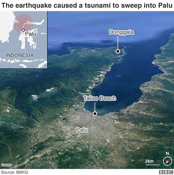
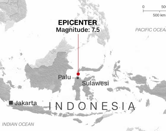
September 28, 2018 Sulawesi Earthquake and Tsunami Wikipedia
Volcano erupts on Indonesia's quake and tsunami-hit Sulawesi NBC - October 3, 2018
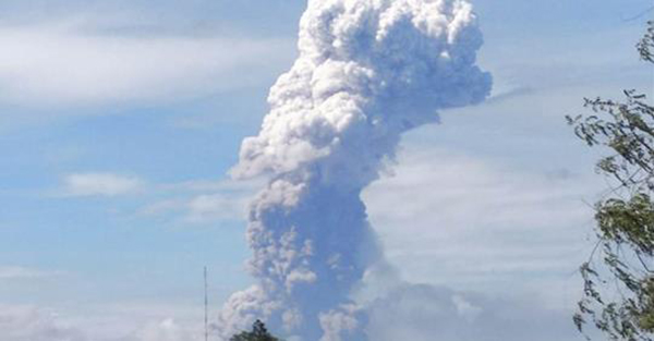
Volcanic activity had been increasing at Mount Soputan since August and began surging Monday, three days after the twin disasters.
Indonesia tsunami: Death toll rises to over 1,200 BBC - October 2, 2018
Indonesia tsunami: Moment quake turns ground into liquid BBC - October 2, 2018
Indonesia tsunami: Aerial shots of debris and survival BBC - October 2, 2018
Why Sulawesi's tsunami is puzzling scientists BBC - October 2, 2018
Warnings Abounded Before Massive Alaska Landslide and Tsunami Live Science - September 8, 2018
A massive landslide and tsunami that denuded the slopes of an Alaskan fjord could reveal warning signs that could help predict future disasters. In a new paper, researchers described the geological fingerprints of the tsunami, which tore through Taan Fjord on Oct.17, 2015, at an estimated 100 mph (162 km/h). Using satellite imagery and field-based measurements, the team discovered that the slope was displaying signs of instability for at least two decades before it failed. The "geologic evidence can help [us] understand past occurrences of similar events and might provide forewarning," the researchers wrote.
Sea Slime Can Trigger 65-Foot Mega-Tsunamis Live Science - February 14, 2018
A layer of ooze made of microscopic fossils may underlie Earth's biggest landslides, a new study finds. The biggest landslides on Earth are not on dry land but rather on the seafloor. For instance, the volcanic eruption of Mount St. Helens in 1980 triggered a collapse of about 0.7 cubic miles (3 cubic kilometers) of rock, but the Storegga "megaslide" offshore Norway about 8,150 years ago sent more than 1,000 times more material crashing downward, previous research found. Submarine landslides are not just perils for life underwater; they can trigger catastrophic tsunami that can wreak havoc on land. For example, prior work suggested that the Storegga megaslide triggered a tsunami that deluged surrounding coasts with waves up to 65 feet (20 meters) high.
A 6,000-Year-Old partial skull found in what is now Papua New Guinea may be from earliest known Tsunami victim Live Science - December 11, 2021
A 6,000-year-old partial skull found in what is now Papua New Guinea represents one of the earliest examples of human remains from the Pacific Islands region, and now it has additional significance: New research shows the skull may represent the first known evidence of a tsunami victim. For decades, scientists suspected that there was something unusual about the sedimentary deposits near the small town of Aitape (EYE'-tuh-PAY') where the skull was discovered in 1929, and researchers recently revisited the site to dig a little deeper into the dirt where the skull had been buried. They realized that certain patterns in the sediments displayed the trademark "fingerprints" of an ancient tsunami - an enormous and powerful wave that forms after massive disturbances in the ocean floor, such as earthquakes or volcanic eruptions, often devastating coastal regions. Thousands of years ago, a tsunami likely carried the skull to that spot, and it may have even claimed the person's life,
Tsunami enabled hundreds of aquatic species to raft across Pacific PhysOrg - September 28, 2017
The 2011 Japanese tsunami set the stage for something unprecedented. For the first time in recorded history, scientists have detected entire communities of coastal species crossing the ocean by floating on makeshift rafts. Nearly 300 species have appeared on the shores of Hawaii and the U.S. West Coast attached to tsunami debris.
Mexico's strongest earthquake in a century leaves dozens dead CNN - September 8, 2017
2017 Chiapas earthquake Wikipedia
On September 7, 2017, at 11:49 p.m. CDT, a magnitude 8.1 earthquake occurred off the coast of Chiapas, Mexico. At least 32 people have died. The earthquake also generated a tsunami with waves of 1 metre (3 ft 3 in) above tide level; tsunami alerts have been issued for surrounding areas. It was the strongest earthquake recorded in Mexico in a century as well as the second strongest recorded in the country's history, behind the magnitude 8.6 earthquake in 1787.[8] It is also the most intense recorded globally in 2017. The earthquake caused some buildings in Mexico City to shake and several earthquake alarms in Mexico City were activated, prompting the evacuation of buildings. The incident prompted a review of the system.
Underwater ruins from lost Roman city reveal the tsunami that devastated Mediterranean region 1,600 years ago Daily Mail - September 1, 2017
Vast underwater ruins from an ancient Roman city have been discovered off northeast Tunisia. The find confirms a theory that the city of Neapolis was partly submerged by a tsunami in the 4th century AD. It also verifies that Neapolis was once the largest centre in the Roman world for the production of garum, a fermented fish-based condiment that was a favorite of ancient Rome.
California Faces Threat of Earthquake-Triggered Tsunamis Live Science - September 7, 2015
Californians may be used to hearing about the threat of potentially deadly earthquakes, but a new study finds that quake-triggered tsunamis pose a greater risk to Southern California than previously thought. Tsunamis are monster waves that can reach more than 100 feet (30 meters) high. They are often caused by earthquakes; the 2004 Banda Aceh earthquake and tsunami killed about 250,000 people, while the 2011 Tohoku earthquake and tsunami that struck offshore of Japan killed about 20,000 people and triggered a nuclear disaster. Tsunamis increase in size as the depth of water in which they occur decreases. Since water depth is usually shallow near coastlines, tsunamis can grow as they approach land, becoming particularly dangerous along heavily populated coastlines, such as those in Southern California.
Small Islands Amplify Tsunami Flooding Live Science - November 6, 2014
Small offshore islands help protect beaches from storm waves, but they're no match for tsunamis. It turns out that small islands boost the power of big tsunami waves, rather than absorbing their impact, a new study shows. In a computer model, a small island amplified tsunami flooding directly behind it by up to 70 percent. The study shows that some areas that were supposed to be at low risk are at higher risk than anticipated. Tsunami waves in the ocean are generated by the sudden motion of the seafloor or by underwater landslides. The rapid movement is like a giant paddle stroke that creates a series of huge ripples that transform into terrifying waves closer to shore. The length between the top (or crest) of each wave can be as much as 100 miles (160 kilometers).
Sumatra coastal cave records stunning tsunami history BBC - December 12, 2013
A cave on the northwestern coast of Sumatra holds a remarkable record of big tsunamis in the Indian Ocean. The limestone opening, close to Banda Aceh, retains the sandy deposits washed ashore by huge, earthquake-induced waves over thousands of years. Scientists are using the site to help determine the frequency of catastrophes like the event of 26 December 2004. This is being done by dating the cave's tsunami-borne sediments, which are easy to see between layers of bat droppings.
Small tsunami reaches Japan after earthquake BBC - October 26, 2013
A small tsunami triggered by a quake has hit Japan's eastern coast - where the crippled Fukushima nuclear plant is located - but no damage is reported. The 30cm (1ft) waves reached the region after the 7.1 magnitude tremor struck at a depth of 10km (six miles), about 320km off the coast.
Underwater Avalanche! Melting Ice Caps Could Trigger Tsunamis Live Science - August 16, 2013
If melting ice caps trigger rapid sea level rise, the strain that the edges of continents could experience might set off underwater landslides, new research suggests. Submarine landslides happen on every continental margin, the underwater parts of continental plates bordering oceanic plates. These underwater avalanches, which can happen when underwater slopes get hit by earthquakes or otherwise have too much weight loaded onto them, can generate dangerous tsunamis. A staggering half of all the Earth moved by submarine landslides over the past 125,000 years apparently happened between 8,000 and 15,000 years ago. "This time period coincides with the period of most rapid sea level rise following the end of the last ice age," said study co-author Daniel Brothers, a geophysicist at the U.S. Geological Survey's Coastal and Marine Science Center in Woods Hole, Mass.
Ancient Caribbean Tsunami Likely Altered Ecosystems Live Science - January 30, 2013
An ancient tsunami caused dramatic long-term ecological changes in the Caribbean more than 3,000 years ago, new research suggests. Scientists investigated sediments from a coastal lagoon on the Caribbean island of Bonaire about 50 miles (80 kilometers) north of the Venezuelan coast. The Caribbean is highly vulnerable to coastal hazards such as hurricanes, tsunamis, mudslides and floods. Bonaire has not experienced a tsunami during the past 500 years of its recorded history. However, analysis of the size of sediment grains found on the island, the organic matter present in the sediment (such as animal remains and carbonate minerals), as well as other factors suggest that a devastating wave struck the island about 3,000 to 3,300 years ago.
Glacial Tsunami - Text and Video
Video Captures Near-Deadly Iceberg 'Tsunami' Live Science - August 8, 2012
One second you're volunteering to be your uncle's translator, and the next a glacial wave nearly sinks your ship. Jens Moller was visiting family near Ilulissat, Greenland, when he decided to go for a boat ride with his uncle to serve as a translator for an Australian tourist, and to have a look at the local glaciers. Moller, who's from Greenland but speaks fluent English, hopped aboard his uncle's 18-foot (5.5-meter) ship. Upon inspecting the glaciers at a place named Eqi, the group heard some cracking. Thinking that a small section of the glacier was about to fall into the water, Moller started filming with his video camera.
The biggest crash on Earth: India slides under Tibet, but how? PhysOrg - September 16, 2010
During the collision of India with the Eurasian continent, the Indian plate is pushed about 500 kilometers under Tibet, reaching a depth of 250 kilometers. The result of this largest collision in the world is the world's highest mountain range, but the tsunami in the Indian Ocean from 2004 was also created by earthquakes generated by this collision.
Triple whammy triggered Samoa tsunami PhysOrg - August 18, 2010
A new study shows that a great earthquake and tsunami that killed 192 people in Samoa, American Samoa and northern Tonga on Sept. 29, 2009, actually was triple whammy. University of Utah seismologist Keith Koper says the main quake of magnitude 8.1 concealed and triggered two major quakes of magnitude 7.8 that occurred within two minutes of the main shock. Stars on map show epicenters of the three quakes. Dashed lines show boundaries between Earth's crustal plates, and arrows show plate motions. The 8.1 quake occurred when the Pacific plate cracked as it dived slowly westward beneath the Tonga block of the Australia plate, triggering the two 7.8 quakes on the boundary between the Pacific plate and Tonga block. Such a pattern never had been observed previously. Credit: Keith Koper, University of Utah Seismograph Stations.
Earthquake double whammy caused 2009 Tonga tsunami BBC - August 18, 2010
A strange double earthquake was responsible for the tsunami that devastated parts of the South Pacific in 2009, scientists claim.
In a rare set of events, an initial 8.1 magnitude earthquake was immediately followed by a second 8.0 shock. The resulting tsunami devastated the South Pacific islands of Tonga and Samoa. An estimated 192 people died as four waves each more than five metres high surged inland.
Contrary to recent hypothesis, 'chevrons' are not evidence of megatsunamis PhysOrg - April 29, 2009
A persistent school of thought in recent years has held that so-called "chevrons," large U- or V-shaped formations found in some of the world's coastal areas, are evidence of megatsunamis caused by asteroids or comets slamming into the ocean
Sumatra Earthquakes and Tsunami Wikipedia - September 12, 2007
The wave that destroyed Atlantis- Was it a tsunami? BBC - April 21, 2007
The legend of Atlantis, the country that disappeared under the sea, may be more than just a myth. Research on the Greek island of Crete suggests Europe's earliest civilization was destroyed by a giant tsunami. Until about 3,500 years ago, a spectacular ancient civilization was flourishing in the Eastern Mediterranean. The ancient Minoans were building palaces, paved streets and sewers, while most Europeans were still living in primitive huts. But around 1500BC the people who spawned the myths of the Minotaur and the Labyrinth abruptly disappeared. Now the mystery of their cataclysmic end may finally have been solved.
Solomon Islands earthquake and tsunami on Monday 04/02/07 Wikipedia
The 2007 Solomon Islands earthquake took place on 2 April 2007, near the provincial capital of Gizo on Ghizo Island, in the Solomon Islands. Its magnitude was calculated by the United States Geological Survey (USGS) as being at 8.1 on the moment magnitude scale. The tsunami that followed the earthquake killed 52 people. According to the USGS, the earthquake was recorded around 7:39:56 a.m. local time (UTC+11). The focus was 10 km (6 mi) deep and 40 km (25 mi) South South-East of Gizo township on New Georgia Islands in Western Province. There were numerous aftershocks, the largest of which had a magnitude of 6.2.
1998 Papua New Guinea earthquake Wikipedia
The 1998 Papua New Guinea earthquake was a magnitude 7.0 earthquake that took place in the early evening of Friday, 17 July 1998. The earthquake struck the north coast region of Papua New Guinea, 25 km (16 mi) from the coast near Aitape, and caused a large undersea landslide, which in turn caused a tsunami that hit the coast, killing more than 2200 people.
Papua New Guinea Tsunami 1998 -- AP - July 17, 1998
A village of low huts made of woven coconut palm leaves and sticks rises from a hill well behind the ruins of beachfront villages smashed by a huge and deadly wave. Survivors, battered, without possessions, many badly injured or dying, scrambled into the hills after the tsunami Friday that killed perhaps as many as 6,000 people in several coastal villages. The new, nameless village depends on emergency supplies of rice, flour and water delivered by air and on the meager pickings of a few vegetable gardens and whatever can be foraged from the forest. Unused fishing traps lie around the huts.