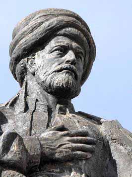
Piri Reis was an Ottoman Kaptan-i Derya, geographer and cartographer born between 1465 and 1470 and died in 1554 or 1555. He is primarily known today for his maps and charts collected in his Kitab-i Bahriye (Book of Navigation), a book which contains detailed information on navigation as well as very accurate for its time charts describing the important ports and cities of the Mediterranean Sea.
Little is known about the identity of Piri Reis. Even the name roughly translated means "sea captain". His origin is debatable, with sources referring to him as Christian, possibly Greek, Jewish, or ethnic Turkish. Hadji Ahmed Muhiddin Piri was born either in Gallipoli of the European part of the Ottoman Empire or in Karaman, central Anatolia, but the exact date of his birth is unknown.
He was son of Hadji Mehmed Piri, and began engaging in piracy when he was young, in 1481, following his uncle Kemal Reis, a well-known pirate and seafarer of the time who later became famous Admiral of the Ottoman fleet. During the periods the Ottomans were at war, together with his uncle, he took part in many naval fights against Spanish, Genoese and Venetians, including the First Battle of Lepanto (Battle of Zonchio) in 1499 and Second Battle of Lepanto (Battle of Modon) in 1500. When his uncle Kemal Reis drowned in 1511 when his ship wrecked by a storm, Piri returned to Gallipoli where he started working his study about navigation.
He gained fame as a cartographer when a small part of his first world map (prepared in 1513) was discovered in 1929 at Topkapő Palace in Istanbul. His world map is the oldest known Turkish atlas showing the New World, and one of the oldest maps of America still in existence in the world. (The oldest known map of America that is still in existence is the map drawn by Juan de la Cosa in 1500, which is conserved in the Naval Museum (Museo Naval) of Madrid, Spain.) Piri Reis' map is centered in Sahara at the Tropic of Cancer latitude.
By 1516 he was again at sea as a ship's captain in the Ottoman fleet. He took part in the 1516-17 campaign against Egypt. In 1522 he participated in the siege of Rhodes against the Knights of St. John which ended with the island's surrender to the Ottomans on December 25, 1522 and the permanent departure of the Knights from Rhodes on January 1, 1523. In 1524 he captained the ship that took the tragic Vizier Pargali Ibrahim Pasha to Egypt.
In 1547, Piri had risen to the rank of Reis (admiral) as commander of the Ottoman fleet in the Indian Ocean and admiral of the fleet in Egypt, headquartered at Suez.
On February 26, 1548 he recaptured Aden from the Portuguese in the Capture of Aden, followed in 1552 by the Capture of Muscat, which Portugal had occupied since 1507, and the important island of Kish. Turning further east, Piri Reis captured the island of Hormuz in the Strait of Hormuz, at the entrance of the Persian Gulf. When the Portuguese turned their attention to the Persian Gulf, Piri Reis occupied the Qatar peninsula and the island of Bahrain to deprive the Portuguese of suitable bases on the Arabian coast.
He then returned to Egypt, an old man approaching the age of 90. When he refused to support the Ottoman governor of Basra, Kubad Pasha, in another campaign against the Portuguese in the northern Persian Gulf, Piri Reis was publicly beheaded in 1554 or 1555.
Several warships and submarines of the Turkish Navy have been named after Piri Reis.
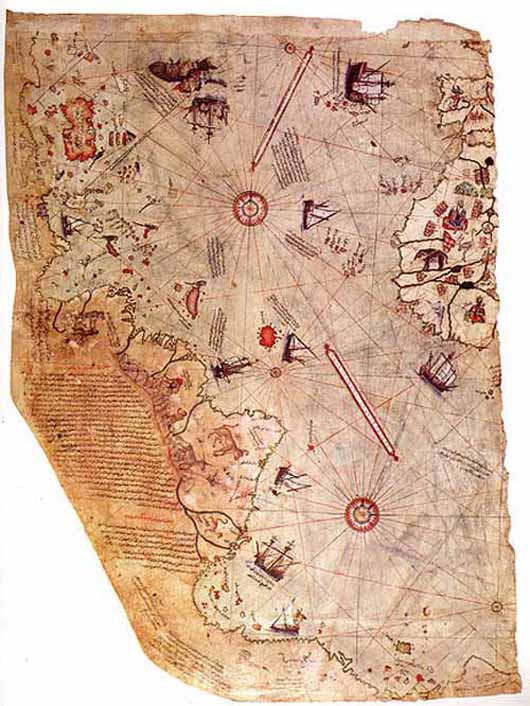
Surviving fragment of the first World Map of Piri Reis (1513)
The Piri Reis map is a pre-modern world map compiled in 1513 from military intelligence by the Ottoman-Turkish admiral and cartographer Piri Reis. The half of the map that survives shows the western coasts of Europe and North Africa and the coast of Brazil with reasonable accuracy. Various Atlantic islands including the Azores and Canary Islands are depicted, as is the mythical island of Antillia and possibly Japan. The historical importance of the map lies in its demonstration of the extent of exploration of the New World by approximately 1510, perhaps before others. It used 10 Arabian sources, 4 Indian maps sourced from Portuguese and one map of Columbus.
The map is the extant western third of a world map drawn on gazelle skin, with dimensions reported as 90 cm x 63 cm, 86 cm x 60 cm, 90 cm x 65 cm, 85 cm x 60 cm, 87 cm x 63 cm, and 86 cm x 62 cm. These discrepancies are largely due to the damaged corner. The surviving portion primarily details the western coast of Africa and the eastern coast of South America.
The map was signed by Piri Reis, an Ottoman-Turkish admiral, geographer and cartographer, and dated to the month of Muharram in the Islamic year 919 AH, equivalent to 1513 AD. It was presented to Ottoman Sultan Selim I in 1517. In the map's legend, Piri inscribed that the map was based on about twenty charts and mapper mundi - a general term used to describe medieval European maps of the world..
According to Piri, these maps included eight Ptolemaic maps constructed during the era of Alexander the Great, an Arabic map of India, four newly drawn Portuguese maps from Sindh, Pakistan and a map by Christopher Columbus of the western lands. From Inscription 6 on the map:
There is some scholarly debate over whether the 20 charts and mappae mundi in Piri's inscriptions includes the eight Ptolemaic maps, the four Portuguese maps, the Arabic map and the Columbus map. From one perspective, the number of charts and mappae mundi used by Piri equals 20, while in the other, it could mean a total of 34.
Some researchers have claimed that the source maps were found in the ancient Library of Alexandria, based on Piri's allusions to Alexander the Great, the founder of Alexandria, Ptolemy I, who ruled Alexandria in the 4th century BC, and Claudius Ptolemy, the Greek geographer and cartographer who lived in Alexandria during the second century AD.
The map was discovered serendipitously on October 9, 1929, through the philological work of the German theologian, Gustav Adolf Deissmann (1866-1937). He had been commissioned by the Turkish Ministry of Education to catalogue the Topkapő Sarayi library's non-Islamic items. At Deissmann's request to search the palace for old maps and charts, the director Halil Edhem (1861-1938) managed to find some disregarded bundles of material, which he handed over to Deissmann. Realizing that the map might be a unique find, Deissmann showed it to the orientalist Paul Kahle who identified it as a map drawn by Piri Reis.
The discovery caused an international sensation, as it represented the only then known copy of a world map of Christopher Columbus (1451-1506), and was the only 16th century map that showed South America in its proper longitudinal position in relation to Africa. Geographers had spent several centuries unsuccessfully searching for a "lost map of Columbus" that was supposedly drawn while he was in the West Indies.
After reading about the map's discovery in The Illustrated London News, United States Secretary of State Henry L. Stimson contacted the United States Ambassador to Turkey Charles H. Sherrill and requested that an investigation be launched to find the Columbus source map, which he believed may have been in Turkey. In turn, the Turkish government complied with Stimson's request, but they were unsuccessful in locating any of the source maps.
The Piri Reis map is currently located in the Library of the Topkapő Palace in Istanbul, Turkey, but is not usually on display to the public.
The map was depicted on the reverse of the Turkish 10 million lira banknote of 1999-2005 and of the 10 new lira banknote of 2005-2009.

In 1528 Piri Reis drew a second world map, of which a small fragment (showing Greenland and North America from Labrador and Newfoundland in the north to Florida, Cuba and parts of Central America in the south) still survives. According to his imprinting text he had drawn his maps using about twenty foreign charts and mappa mundi (Arab, Spanish, Portuguese, Chinese, Indian and Greek) including one of Christopher Columbus.
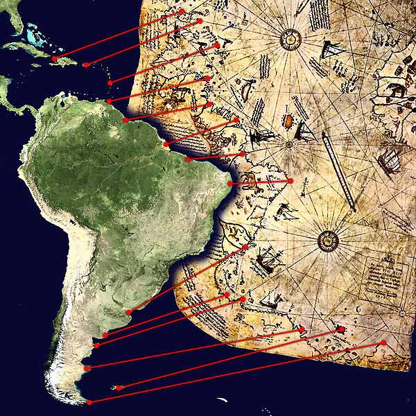
Comparison between a modern projection of South America and Piri Reis's version.
Piri Reis is the author of the Kitab-i Bahriye one of the most famous pre modern books of navigation including a world map. Although he was not an explorer and never sailed to the Atlantic, by making use, according to the imprinting, of about twenty Arab, Spanish, Portuguese, Chinese, Indian and older Greek maps, he managed to give a comprehensive representation of the known world of his era including the recently explored shores of both Atlantic African and American continents (imprinted "These lands and islands are drawn from map of Columbus").
In his text he is also giving as source "maps drawn in the time of Alexander the Great", but most likely he had mistakenly confused the ancient Greek geographer Ptolemy of the 2nd century AD with the same named General of Alexander (of six centuries before) since his map is similar with the Jan of Stobnica famous reproduction map of Ptolemy, printed at 1512.
The ancient book had been translated in Turkish after a personal order of Mehmed II some decades before.
The Columbus origin of the Atlantic part of the map is confirmed by the contained errors (such as Columbus' belief that Cuba was a continental peninsula) since at the time the manuscript produced, the Spaniards were already for two years in Mexico. Apart of the maps, the book also contained detailed information on the major ports, bays, gulfs, capes, peninsulas, islands, straits and ideal shelters of the Mediterranean Sea, as well as techniques of navigation and navigation-related information on astronomy, together with information about the local people of each country and city and the curious aspects of their culture.
There are thirty legends around the world map, twenty-nine in Turkish and one in Arabic, the latter is giving the date as the Muharrem month of 919 AH (corresponding to spring 1513 AD) but most studies identify as more probable date the 1521. It was revised in 1524-5 with additional information and better-crafted charts in order to be presented as a gift to Suleiman I. The revised edition had a total of 434 pages containing 290 maps.
Kitab-i Bahriye has two main sections, with the first section dedicated to information about the types of storms, techniques of using a compass, portolan charts with detailed information on ports and coastlines, methods of finding direction using the stars, characteristics of the major oceans and the lands around them. Special emphasis is given to the discoveries in the New World by Christopher Columbus and those of Vasco da Gama and the other Portuguese seamen on their way to India and the rest of Asia.
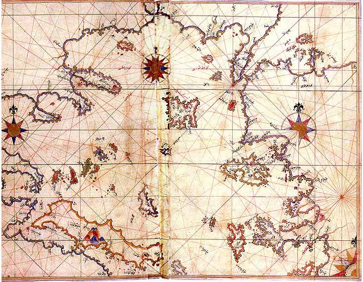
The second section is entirely composed of portolan charts and cruise guides. Each topic contains the map of an island or coastline. In the first book (1521), this section has a total of 132 portolan charts, while the second book (1525) has a total of 210 portolan charts.
The second section starts with the description of the Dardanelles Strait and continues with the islands and coastlines of the Aegean Sea, Ionian Sea, Adriatic Sea, Tyrrhenian Sea, Ligurian Sea, the French Riviera, the Balearic Islands, the coasts of Spain, the Strait of Gibraltar, the Canary Islands, the coasts of North Africa, Egypt and the River Nile, the Levant and the coastline of Anatolia. This section also includes descriptions and drawings of the famous monuments and buildings in every city, as well as biographic information about Piri Reis who also explains the reasons why he preferred to collect these charts in a book instead of drawing a single map, which would not be able to contain so much information and detail.
A century after Piri's death and during the second half of the 17th century a third version of his book was produced which left the text of the second version unaffected while enriching the cartographical part of the manuscript. It included additional new large-scale maps mostly copies of Italian (from Battista Agnese and Jacopo Gastaldi) and Dutch (Abraham Ortelius) works of the previous century. These maps were much more accurate and depict the Black Sea which was not comprised in the original.
Copies of the Kitab-i Bahriye are found in many libraries and museums around the world.
Copies of the first edition (1521) are found in the Topkapi Palace, the Nuruosmaniye Library and the Suleymaniye Library in Istanbul, the Library of the University of Bologna, the National Library of Vienna, the State Library of Dresden, the National Library of France in Paris, the British Museum in London, the Bodleian Library in Oxford and the Walters Art Museum in Baltimore.
Copies of the second edition (1525) are found in the Topkapő Palace, the Kopruluzade Fazől Ahmed Pasa Library, the Suleymaniye Library and the National Library of France.
Charles Hapgood began studying the map in the middle of the 20th century and published the book Maps of the Ancient Sea Kings in 1966.
Hapgood claims this and other maps support a theory of global exploration by a pre-classical undiscovered civilization. He supports this with an analysis of the mathematics of ancient maps and of their accuracy, which he says surpassed instrumentation available at the time of the map's drafting.
Hapgood argued that owing to the map being assembled from components, the Caribbean section was rotated nearly 90Ľ from the top of South America. He attributed this to either copying from a polar projection, or to fit in the space available by hinging the map at that location and giving it an "alternate north", of which other examples are known in maps of the era.
POLE SHIFTS