A desert is a landscape or region that receives very little precipitation. Deserts can be defined as areas that receive an average annual precipitation of less than 250 mm (10 in), or as areas in which more water is lost than falls as precipitation. In the Koppen climate classification system, deserts are classed as BWh (hot desert) or BWk (temperate desert). In the Thornthwaite climate classification system, deserts would be classified as arid megathermal climates.
�Deserts are part of a wider classification of regions that, on an average annual basis, have a moisture deficit (i.e. they can potentially lose more than is received). Deserts are located where vegetation cover is sparse to almost nonexistent.Deserts take up about a third of the Earth's land surface. They usually have a large diurnal and seasonal temperature range, with high daytime temperatures (in summer up to 45 °C or 113 °F), and low night-time temperatures (in winter down to 0 °C; 32 °F) due to extremely low humidity. Water acts to trap infrared radiation from both the sun and the ground, and dry desert air is incapable of blocking sunlight during the day or trapping heat during the night. Thus during daylight most of the sun's heat reaches the ground. As soon as the sun sets, the desert cools quickly by radiating its heat into space. Urban areas in deserts lack large (more than 25 °F/14 °C) daily temperature ranges, partially due to the urban heat island effect.
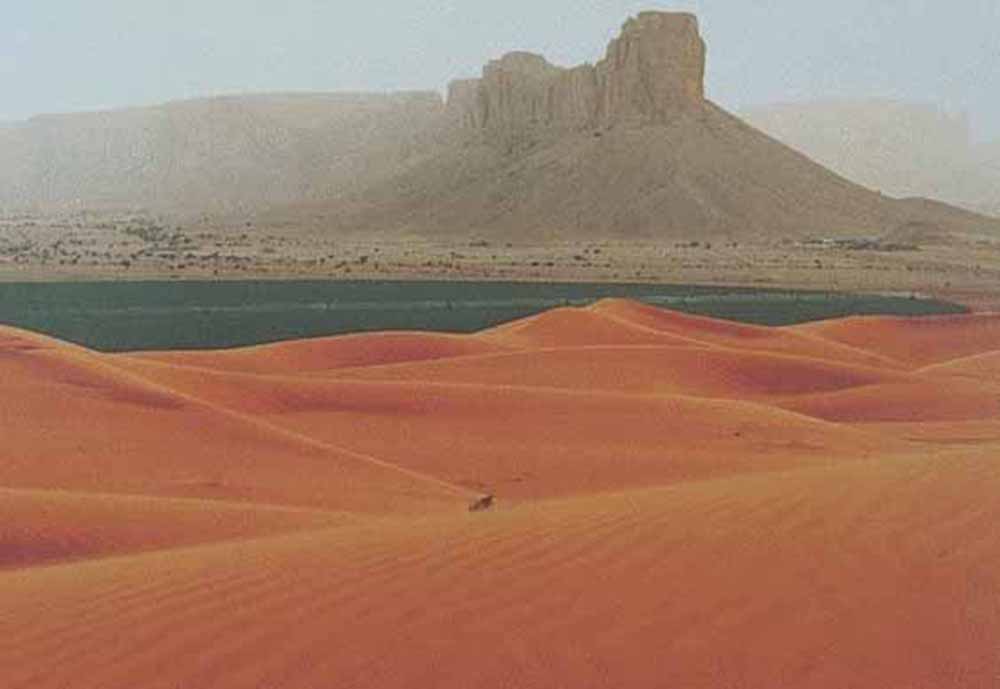
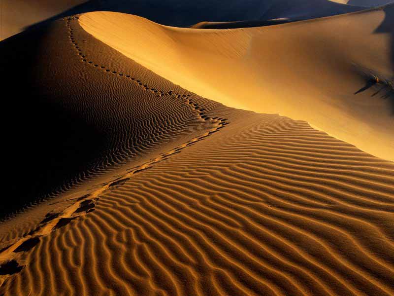
Many deserts are formed by rain shadows, mountains blocking the path of precipitation to the desert. Deserts are often composed of sand and rocky surfaces. Sand dunes called ergs and stony surfaces called hamada surfaces compose a minority of desert surfaces. Exposures of rocky terrain are typical, and reflect minimal soil development and sparseness of vegetation.
Bottomlands may be salt-covered flats. Eolian processes are major factors in shaping desert landscapes. Cold deserts (also known as polar desert) have similar features but the main form of precipitation is snow rather than rain. Antarctica is the world's largest cold desert (composed of about 98 percent thick continental ice sheet and 2 percent barren rock). Some of the barren rock is to be found in the so-called Dry Valleys of Antarctica that almost never get snow, which can have ice-encrusted saline lakes that suggest evaporation far greater than the rare snowfall due to the strong katabatic winds that evaporate even ice. The largest hot desert is the Sahara.
Deserts sometimes contain valuable mineral deposits that were formed in the arid environment or that were exposed by erosion. Due to extreme and consistent dryness, some deserts are ideal places for natural preservation of artifacts and fossils.
In 1953, Peveril Meigs divided desert regions on Earth into three categories according to the amount of precipitation they received. In this now widely accepted system, extremely arid lands have at least 12 consecutive months without rainfall, arid lands have less than 250 millimeters (10 in) of annual rainfall, and semiarid lands have a mean annual precipitation of between 250 and 500 millimeters (10-20 in). Arid and extremely arid lands are deserts, and semiarid grasslands are generally referred to as steppes.
Measurement of rainfall alone can't provide an accurate definition of what a desert is because being arid also depends on evaporation which depends in part on temperature. For example, Phoenix, Arizona receives less than 250 millimeters (10 in) of precipitation per year, and is immediately recognized as being located in a desert due to its arid adapted plants. The North Slope of Alaska's Brooks Range also receives less than 250 millimeters (10 in) of precipitation per year, but is not generally recognized as a desert region.
So "potential evapotranspiration" supplements measurement of rainfall in providing a scientific measurement-based definition of a desert. The water budget of an area can be calculated using the formula P-PE+S, wherein P is precipitation, PE is potential evapotranspiration rates and S is amount of surface storage of water. Evapotranspiration is the combination of water loss through atmospheric evaporation, coupled with the evaporative loss of water through the life processes of plants. Potential evapotranspiration, then, is the amount of water that could evaporate in any given region. As an example, Tucson, Arizona receives about 300 millimeters, (12 in), of rain per year, however about 2500 millimeters, (100 in), of water could evaporate over the course of a year. In other words, about 8 times more water could evaporate from the region than actually falls. Rates of evapotranspiration in other regions such as Alaska are much lower.
There are different forms of deserts. Cold deserts can be covered in snow or ice; frozen water unavailable to plant life. These are more commonly referred to as tundra if a short season of above-freezing temperatures is experienced, or as an ice cap if the temperature remains below freezing year-round, rendering the land almost completely lifeless.
Most non-polar deserts are hot in the day and chilly at night (for the latitude) because of the lack of the moderating effect of water. In some parts of the world, deserts are created by a rain shadow effect in which air masses lose much of their moisture as they move over a mountain range; other areas are arid by virtue of being very far from the nearest available sources of moisture. Deserts are also classified by their geographical location and dominant weather pattern as trade wind, mid-latitude, rain shadow, coastal, monsoon, or polar deserts. Former desert areas presently in non-arid environments are paleodeserts.
Montane deserts are arid places with a very high altitude; the most prominent example is found north of the Himalaya especially in Ladakh region of Jammu and Kashmir, in parts of the Kunlun Mountains and the Tibetan Plateau. Many locations within this category have elevations exceeding 3,000 meters (10,000 ft) and the thermal regime can be hemiboreal. These places owe their profound aridity (the average annual precipitation is often less than 40 mm/1.5in) to being very far from the nearest available sources of moisture. Montane deserts are normally cold.
Rain shadow deserts form when tall mountain ranges block clouds from reaching areas in the direction the wind is going. As the air moves over the mountains, it cools and moisture condenses, causing precipitation on the windward side. Moisture almost never reaches the leeward side of the mountain, resulting in a desert. When that air reaches the leeward side, the air is dry, because it has already lost the majority of its moisture. The air then warms, expands, and blows across the desert. The warm, desiccated air takes with it any remaining small amounts of moisture in the desert.
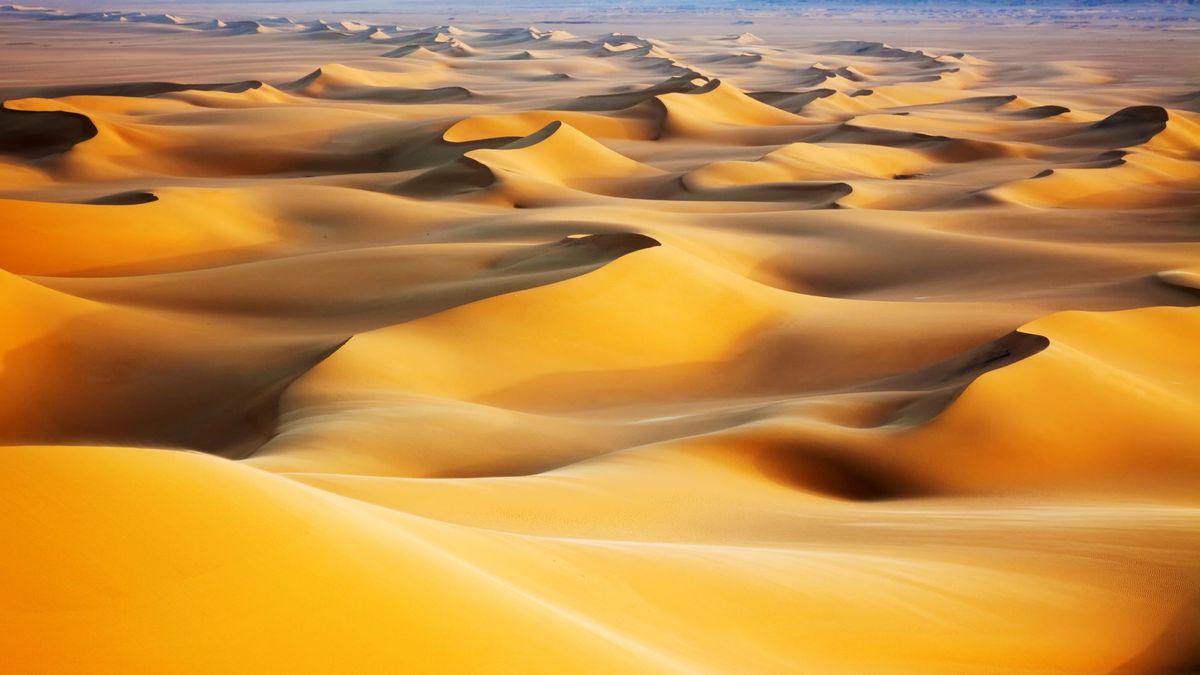
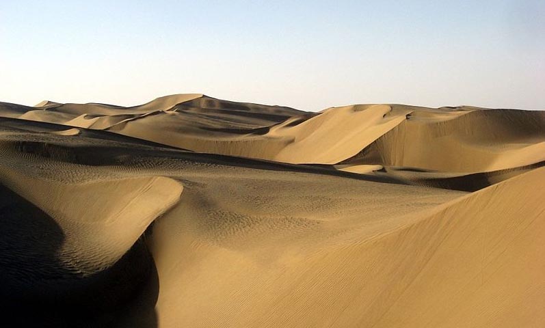
Sand covers only about 20 percent of Earth's deserts. Most of the sand is in sand sheets and sand seas - vast regions of undulating dunes resembling ocean waves "frozen" in an instant of time. In general, there are six forms of deserts:
Hamada deserts, which consist of plateau landforms
Regs, which consist of rock pavements
Ergs, which are formed by sand seas
Intermontane Basins
Badlands, which are located at the margins of arid lands comprising clay-rich soil
The remaining surfaces of arid lands are composed of exposed bedrock outcrops, desert soils, and fluvial deposits including alluvial fans, playas, desert lakes, and oases. Bedrock outcrops commonly occur as small mountains surrounded by extensive erosional plains.
Several different types of dunes exist. Barchan dunes are produced by strong winds blowing across a level surface and are crescent-shaped. Longitudinal or seif dunes are dunes that are parallel to a strong wind that blows in one general direction. Transverse dunes run at a right angle to the constant wind direction. Star dunes are star-shaped and have several ridges that spread out around a point.
Oases are vegetated areas moistened by springs, wells, or by irrigation. Many are artificial. Oases are often the only places in deserts that support crops and permanent habitation.
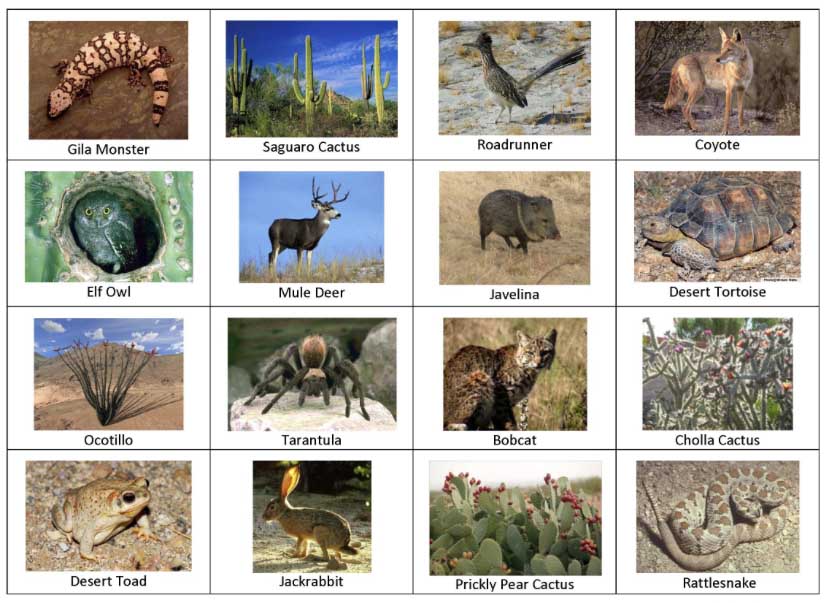
Deserts have a reputation for supporting very little life, but in reality deserts often have high biodiversity, including animals that remain hidden during daylight hours to control body temperature or to limit moisture needs. Some fauna includes the kangaroo rat, coyote, jack rabbit, and many lizards. These animals adapted to live in deserts are called xerocoles. Some flora includes shrubs, Prickly Pears, Desert Holly, and the Brittle bush.
Most desert plants are drought- or salt-tolerant, such as xerophytes. Some store water in their leaves, roots, and stems. Other desert plants have long taproots that penetrate to the water table if present, or have adapted to the weather by having wide-spreading roots to absorb water from a greater area of the ground. Another adaptation is the development of small, spiny leaves which shed less moisture than deciduous leaves with greater surface areas. The stems and leaves of some plants lower the surface velocity of sand-carrying winds and protect the ground from erosion. Even small fungi and microscopic plant organisms found on the soil surface (so-called cryptobiotic soil) can be a vital link in preventing erosion and providing support for other living organisms.
Deserts typically have a plant cover that is sparse but enormously diverse. The giant saguaro cacti of the Sonoran Desert provide nests for desert birds and serve as "trees" of the desert. Saguaro grow slowly but may live up to 200 years. When 9 years old, they are about 15 centimeters (6 in) high. After about 75 years, the cacti develop their first branches. When fully grown, saguaro cacti are 15 meters tall and weigh as much as 10 tons. They dot the Sonoran and reinforce the general impression of deserts as cactus-rich land.
Although cacti are often thought of as characteristic desert plants, other types of plants have adapted well to the arid environment. They include the pea and sunflower families. Cold deserts have grasses and shrubs as dominant vegetation.
Rain does fall occasionally in deserts, and desert storms are often violent. A record 44 millimeters (1.7 in) of rain once fell within 3 hours in the Sahara. Large Saharan storms may deliver up to 1 millimeter per minute. Normally dry stream channels, called arroyos or wadis, can quickly fill after heavy rains, and flash floods make these channels dangerous.
Though little rain falls in deserts, deserts receive runoff from ephemeral, or short-lived, streams fed considerable quantities of sediment for a day or two. Although most deserts are in basins with closed or interior drainage, a few deserts are crossed by 'exotic' rivers that derive their water from outside the desert. Such rivers infiltrate soils and evaporate large amounts of water on their journeys through the deserts, but their volumes are such that they maintain their continuity.
The Nile River, the Colorado River, and the Yellow River are exotic rivers that flow through deserts to deliver their sediments to the sea. Deserts may also have underground springs, rivers, or reservoirs that lie close to the surface, or deep underground. Plants that have not completely adapted to sporadic rainfalls in a desert environment may tap into underground water sources that do not exceed the reach of their root systems.
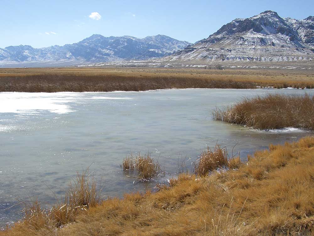
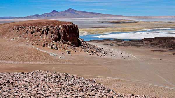
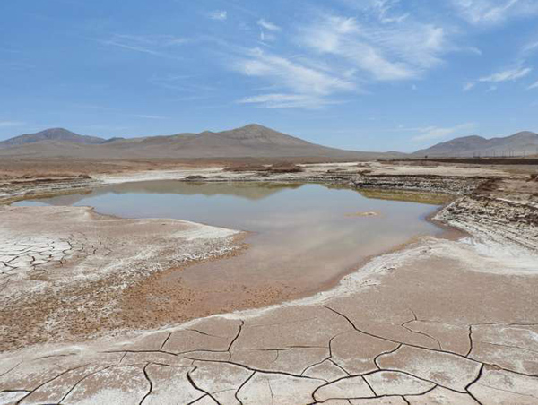
Lakes form where rainfall or meltwater in interior drainage basins is sufficient. Desert lakes are generally shallow, temporary, and salty. Because these lakes are shallow and have a low bottom gradient, wind stress may cause the lake waters to move over many square kilometers. When small lakes dry up, they leave a salt crust or hardpan. The flat area of clay, silt, or sand encrusted with salt that forms is known as a playa.
There are more than a hundred playas in North American deserts. Most are relics of large lakes that existed during the last ice age about 12,000 years ago. Lake Bonneville was a 52,000 kilometers (20,000 miles) lake almost 300 meters (1000 ft) deep in Utah, Nevada, and Idaho during the Ice Age. Today the remnants of Lake Bonneville include Utah's Great Salt Lake, Utah Lake, and Sevier Lake. Because playas are arid landforms from a wetter past, they contain useful clues to climatic change.
When the occasional precipitation does occur, it erodes the desert rocks quickly and powerfully. The flat terrains of hardpans and playas make them excellent racetracks and natural runways for airplanes and spacecraft. Ground-vehicle speed records are commonly established on Bonneville Speedway, a racetrack on the Great Salt Lake hardpan. Space shuttles land on Rogers Lake Playa at Edwards Air Force Base in California.
A desert is a hostile, potentially deadly environment for unprepared humans. In hot deserts, high temperatures cause rapid loss of water due to sweating, and the absence of water sources with which to replenish it can result in dehydration and death within a few days. In addition, unprotected humans are also at risk from heatstroke.
Humans may also have to adapt to sandstorms in some deserts, not just in their adverse effects on respiratory systems and eyes, but also in their potentially harmful effects on equipment such as filters, vehicles and communication equipment. Sandstorms can last for hours, sometimes even days.
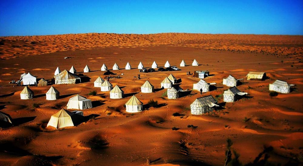
Despite this, some cultures have made hot deserts their home for thousands of years, including the Bedouin, Tuareg tribe and Pueblo people. Modern technology, including advanced irrigation systems, desalinization and air conditioning have made deserts much more hospitable. In the United States and Israel for example, desert farming has found extensive use.
In cold deserts, hypothermia and frostbite are the chief hazards, as well as dehydration in the absence of a source of heat to melt ice for drinking. Falling through pack-ice or surface ice layers into freezing water is a particular danger requiring emergency action to prevent rapid hypothermia. Starvation is also a hazard; in low temperatures the body requires much more food energy to maintain body heat and to move. As with hot deserts, some people such as the Inuit have adapted to the harsh conditions of cold deserts.
Most traditional human life in deserts is nomadic. It depends in hot deserts on finding water, and on following infrequent rains to obtain grazing for livestock. In cold deserts, it depends on finding good hunting and fishing grounds, on sheltering from blizzards and winter extremes, and on storing enough food for winter. Permanent settlement in both kinds of deserts requires permanent water and food sources and adequate shelter, or the technology and energy sources to provide it.
Many deserts are flat and featureless, lacking landmarks, or composed of repeating landforms such as sand dunes or the jumbled ice-fields of glaciers. Advanced skills or devices are required to navigate through such landscapes and inexperienced travelers may perish when supplies run out after becoming lost. In addition sandstorms or blizzards may cause disorientation in severely-reduced visibility.
The danger represented by wild animals in deserts has been featured in explorers' accounts but does not cause higher rates of death than in other environments such as rain forests or savanna woodland, and generally does not by itself affect human distribution. Defence against polar bears may be advisable in some areas of the Arctic, as may precautions against venomous snakes and scorpions in choosing sites at which to camp in some hot deserts.
Some mineral deposits are formed, improved, or preserved by geologic processes that occur in arid lands as a consequence of climate. Ground water leaches ore minerals and redeposits them in zones near the water table. This leaching process concentrates these minerals as ore that can be mined.
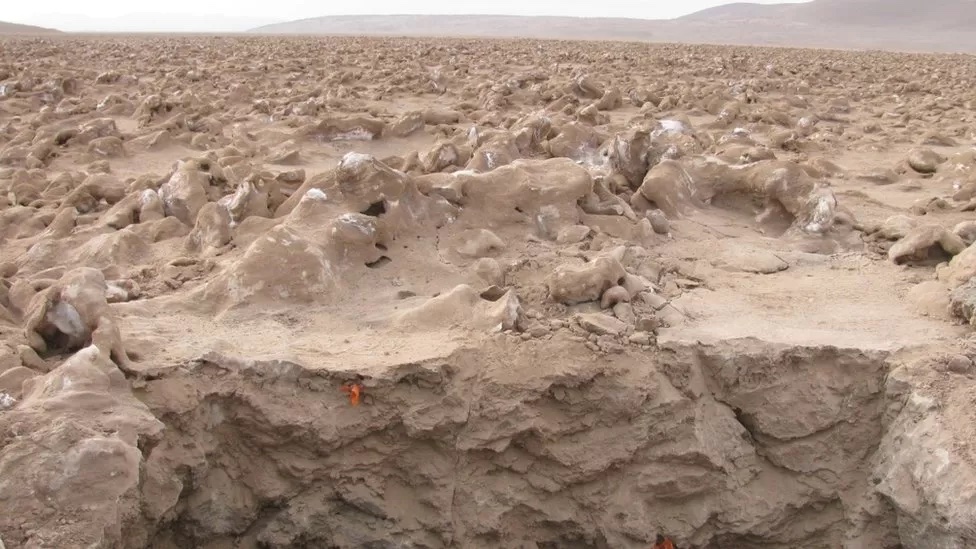
Evaporation in arid lands enriches mineral accumulation in their lakes. Playas may be sources of mineral deposits formed by evaporation. Water evaporating in closed basins precipitates minerals such as gypsum, salts (including sodium nitrate and sodium chloride), and borates.
The minerals formed in these evaporite deposits depend on the composition and temperature of the saline waters at the time of deposition.
Significant evaporite resources occur in the Great Basin Desert of the United States, mineral deposits made forever famous by the "20-mule teams" that once hauled borax-laden wagons from Death Valley to the railroad.
Boron, from borax and borate evaporites, is an essential ingredient in the manufacture of glass, ceramics, enamel, agricultural chemicals, water softeners, and pharmaceuticals.
Borates are mined from evaporite deposits at Searles Lake, California, and other desert locations. The total value of chemicals that have been produced from Searles Lake substantially exceeds US$1 billion.
Valuable minerals located in arid lands include copper in the United States, Chile, Peru, and Iran; iron and lead-zinc ore in Australia; chromite in Turkey; and gold, silver, and uranium deposits in Australia and the United States.
Nonmetallic mineral resources and rocks such as beryllium, mica, lithium, clays, pumice, and scoria also occur in arid regions.
Sodium carbonate, sulfate, borate, nitrate, lithium, bromine, iodine, calcium, and strontium compounds come from sediments and near-surface brines formed by evaporation of inland bodies of water, often during geologically recent times.
The Green River Formation of Colorado, Wyoming, and Utah contains alluvial fan deposits and playa evaporites created in a huge lake whose level fluctuated for millions of years. Economically significant deposits of trona, a major source of sodium compounds, and thick layers of oil shale were created in the arid environment.
Some of the more productive petroleum areas on Earth are found in arid and semiarid regions of Africa and the Mideast, although the oil fields were originally formed in shallow marine environments. Recent climate change has placed these reservoirs in an arid environment. It's notworthy that Ghawar, the world's largest and most productive oilfield is mostly under the Empty Quarter and Al-Dahna deserts.
Other oil reservoirs, however, are presumed to be eolian in origin and are presently found in humid environments. The Rotliegendes, a hydrocarbon reservoir in the North Sea, is associated with extensive evaporite deposits. Many of the major U.S. hydrocarbon resources may come from eolian sands. Ancient alluvial fan sequences may also be hydrocarbon reservoirs.
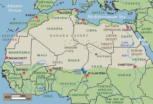
The Sahara Desert - or 'the Great Desert' - is the world's hottest desert, and the third largest desert after Antarctica and the Arctic. At over 9,400,000 square kilometres (3,600,000 sq mi), it covers most of North Africa, making it almost as large as China or the United States. The Sahara stretches from the Red Sea, including parts of the Mediterranean coasts to the Atlantic Ocean. To the south, it is delimited by the Sahel, a belt of semi-arid tropical savanna that composes the northern region of central and western Sub-Saharan Africa. Some of the sand dunes can reach 180 metres (590 ft) in height. The name comes from the plural Arabic language word for desert.
The Sahara covers large parts of Algeria, Chad, Egypt, Libya, Mali, Mauritania, Morocco, Niger, Western Sahara, Sudan and Tunisia. It is one of three distinct physiographic provinces of the African massive physiographic division. The desert landforms of the Sahara are shaped by wind or by occasional rains and include sand dunes and dune fields or sand seas (erg), stone plateaus (hamada), gravel plains (reg), dry valleys, and salt flats (shatt or chott). Unusual landforms include the Richat Structure in Mauritania. Most of the rivers and streams in the Sahara are seasonal or intermittent, the chief exception being the Nile River, which crosses the desert from its origins in central Africa to empty into the Mediterranean. On January 18, 2012, snow fell in several places in western Algeria. Strong winds blew the snow across roads and buildings in Bechar Province. Read more ...
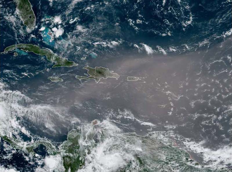
A plume of Saharan dust stretching from the coast of Africa to the northwestern Caribbean and into the Gulf of Mexico is forecast to reach Florida by Saturday, May 31, 2025. Southern and central parts of the state are expected to experience hazy skies and reduced air quality over the weekend. A denser plume could arrive by mid-next week, with the dust reaching Texas by Tuesday, June 3. Watchers - May 31, 2025


Saharan dust (also African dust, or Sahara dust storms) is an aeolian mineral dust from the Sahara, the largest hot desert in the world. The desert spans just over 9 million square kilometers, from the Atlantic Ocean to the Red Sea, from the Mediterranean Sea to the Niger River valley and the Sudan region in the south. Read more ...
Ancient DNA sheds light on origins of 7,000-year-old Saharan mummies CNN - April 4, 2025

Today, the view from the Takarkori rock shelter in southwestern Libya is of endless sandy dunes and barren rock, but 7,000 years ago, this region of the Sahara Desert was a far lusher, hospitable place. Now, scientists aiming to understand the origins of inhabitants of the 'green Sahara' say they have managed to recover the first whole genomes - detailed genetic information - from the remains of two women buried at Takarkori.
Earth from space: Wandering sand dunes circle gigantic 'eye' sculpted by ancient city-killer meteor in the Sahara Live Science - November 26, 2024
Video: The Sahara Desert flooded for the first time in decades. Here's what it looks like CNN Science - October 14, 2024
Rare Heavy Rainfall Sees Sahara Flood For First Time In Decades IFL Science - October 14, 2024
Our Atmosphere Transforms Dust From The Sahara Into Minerals That Fuel Life Science Alert - September 29, 2024
Stunning New Photos Of The 'Eye Of The Sahara' As Seen From The ISS IFL Science - July 26, 2024
Astronaut Looks Down At Sahara Desert From The ISS, Sees Giant Skull Looking Back IFL Science - November 2, 2023
How the Sahara turned from a vast forest to the arid landscape we see today Live Science - August 9, 2023
Millions of years ago, the Sahara was a green oasis covered in trees and grassland. So how did it become world's biggest hot desert, roughly the size of the entire U.S.?
The 'Eye Of The Sahara': A Geological Mystery Staring Into Space - January 22, 2023
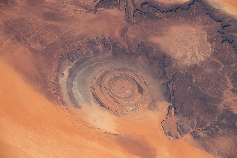
The Eye of the Sahara looks just like an enormous impact crater sitting in the middle of the Sahara Desert of Mauritania. Stretching 50 kilometers (30 miles) in diameter, comprised of a series of uniform ripples, this crater-esque anomaly is in fact entirely terrestrial.
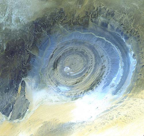
Richat Structure is a prominent circular geological feature in the Sahara's Adrar Plateau, near Ouadane, west-central Mauritania, Northwest Africa. In the local dialect, Richat means feathers. It is known locally in Arabic as tagense - the circular opening of the leather pouch used to draw water from local wells. It is an eroded geological dome, 40 kilometres (25 mi) in diameter, exposing sedimentary rock in layers that appear as concentric rings. Igneous rock is exposed inside and there are spectacular rhyolites and gabbros which have undergone hydrothermal alteration, and a central megabreccia. The structure is also the location of exceptional accumulations of Acheulean archaeological artifacts. It was selected as one of the first 100 geological heritage sites identified by the International Union of Geological Sciences (IUGS) to be of the highest scientific value.
Here are the top three ways this week's Saharan dust plume will affect you PhysOrg - June 23, 2020
Sunrises and sunsets will look especially stunning this week thanks to the Saharan dust plume making the 5,000-mile trek across the Atlantic to the US. Here are the top three ways this week's Saharan dust plume will affect you
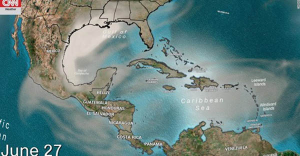
Sahara dust blankets Caribbean, air quality hazardous PhysOrg - June 23, 2020
A vast cloud of Sahara dust is blanketing the Caribbean as it heads to the U.S. with a size and concentration that experts say hasn't been seen in half a century. Air quality across most of the region fell to record "hazardous" levels and experts who nicknamed the event the "Godzilla dust cloud" warned people to stay indoors and use air filters if they have one.
Entomologist confirms first Saharan farming 10,000 years ago PhysOrg - March 17, 2018
By analyzing a prehistoric site in the Libyan desert, a team of researchers from the universities of Huddersfield, Rome and Modena & Reggio Emilia has been able to establish that people in Saharan Africa were cultivating and storing wild cereals 10,000 years ago. In addition to revelations about early agricultural practices, there could be a lesson for the future, if global warming leads to a necessity for alternative crops.
Did humans create the Sahara Desert? PhysOrg - March 14, 2017
New research investigating the transition of the Sahara from a lush, green landscape 10,000 years ago to the arid conditions found today, suggests that humans may have played an active role in its desertification. The desertification of the Sahara has long been a target for scientists trying to understand climate and ecological tipping points. A new paper challenges the conclusions of most studies done to date that point to changes in the Earth's orbit or natural changes in vegetation as the major driving forces.
Snow falls in Sahara for first time in 37 years CNN - December 22, 2016

The dry, hot Sahara desert was hit by a freak snowfall on December 19. It's the first time snow has fallen in the region in 37 years. Incredible pictures by amateur photographer Karim Bouchetata show the town's red dunes dramatically capped with white snow. The last time flakes are reported to have fallen here was when a brief blizzard hit town in February 1979.
Earth's Richat Structure NASA - May 19, 2013

What on Earth is that? The Richat Structure in the Sahara Desert of Mauritania is easily visible from space because it is nearly 50 kilometers across. Once thought to be an impact crater, the Richat Structure's flat middle and lack of shock-altered rock indicates otherwise. The possibility that the Richat Structure was formed by a volcanic eruption also seems improbable because of the lack of a dome of igneous or volcanic rock. Rather, the layered sedimentary rock of the Richat structure is now thought by many to have been caused by uplifted rock sculpted by erosion. The above image was captured by the ASTER instruments onboard the orbiting orbiting Terra satellite. Why the Richat Structure is nearly circular remains a mystery.
Research points to abrupt and widespread climate shift in the Sahara 5,000 years ago PhysOrg - April 5, 2013

As recently as 5,000 years ago, the Sahara - today a vast desert in northern Africa, spanning more than 3.5 million square miles - was a verdant landscape, with sprawling vegetation and numerous lakes. Ancient cave paintings in the region depict hippos in watering holes, and roving herds of elephants and giraffes - a vibrant contrast with today's barren, inhospitable terrain.
Fish Swam the Sahara, Bolstering Out of Africa Theory Live Science - December 29, 2010

Fish may have once swum across the Sahara, a finding that could shed light on how humanity made its way out of Africa, researchers said. The cradle of humanity lies south of the Sahara, which begs the question as to how our species made its way past it. The Sahara is the largest hot desert in the world, and would seem a major barrier for any humans striving to migrate off the continent.
How Earth's orbital shift shaped the Sahara PhysOrg - December 22, 2010

A change in the Earth's orbit, many scientists believe, transformed the "Green Sahara" into what is now the largest desert on the planet. While scientists are still trying to find out if the slow shift in orbit had rapid or gradual environmental consequences, they say Earth's orbit will continue to change today and into the future.
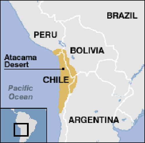
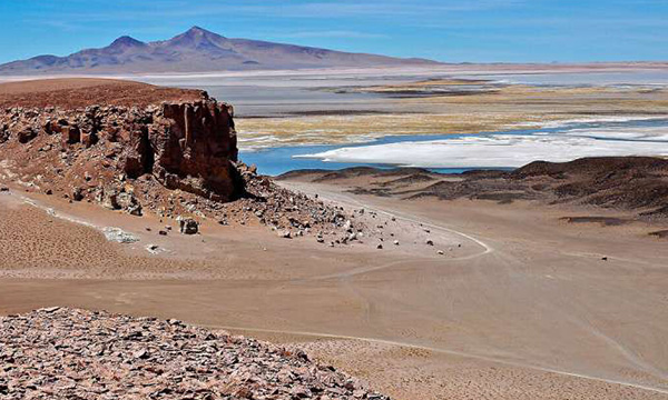
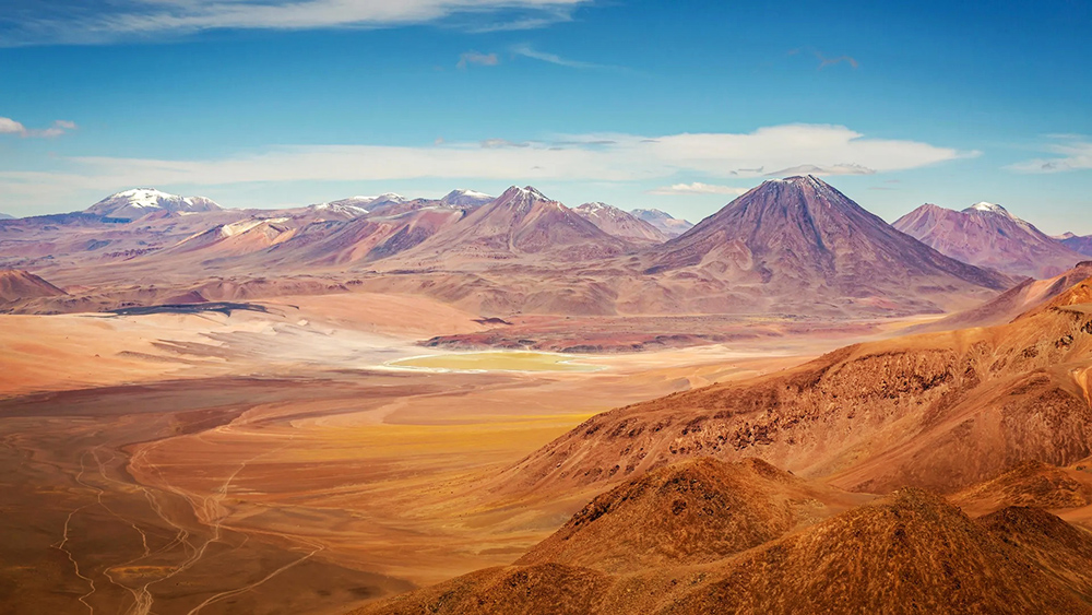
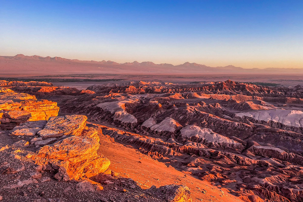
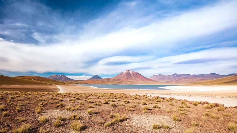
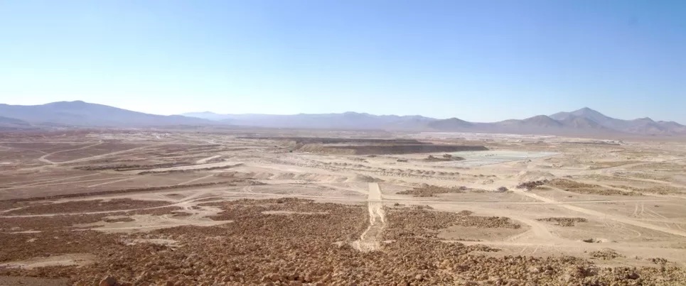
The Atacama Desert is commonly known as the driest place in the world. It is a plateau in South America, covering a 1,000-kilometre (600 mi) strip of land on the Pacific coast, west of the Andes mountains. It is the driest hot desert in the world. The Atacama occupies 105,000 square kilometres (41,000 sq mi) composed mostly of salt lakes, sand, and felsic lava flows towards the Andes. Sodium nitrate has been mined for explosives and fertilizer in the Atacama since the middle of the 19th century - nearly 3 million tons during World War I.
The Desert is perhaps the oldest desert on earth and has experienced extreme hyper-aridity for at least 3 million years, making it the oldest continuously arid region on earth. The long history of aridity raises the possibility that supergene mineralization, under the appropriate conditions can form in arid environments, instead of requiring humid conditions. Geological research suggests that in some sections of the Atacama Desert, such as in today's Chile, hyper-aridity has persisted for the last 200 million years (since the Triassic).
Chile has one of the highest number of UFO sightings in the world. Most people can report a time they saw a UFO.
The Atacama Desert has not experienced rainfall for centuries. It is one of the few locations on Earth that mimics conditions on Mars.
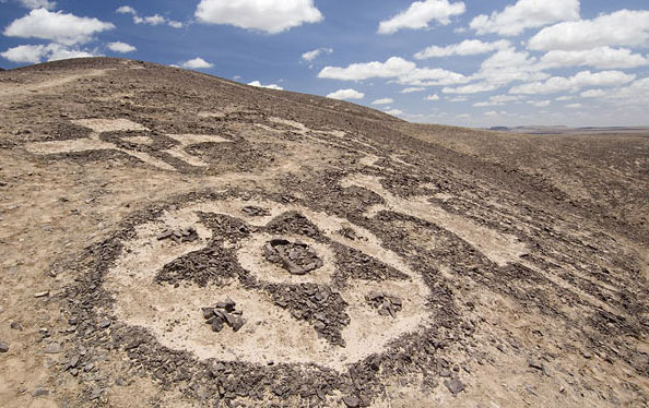
The huge giant figures or geoglyphs - to be seen from the sky - found in the Atacama desert resemble those of the Nazca Lines which 500 miles north of the desert with over 1,100 glyphs spread over 155 square miles. The Atacama desert glyphs number over 5,000 covering an area of 90,000 square miles.

(This humanoid looking figure takes us to Ancient Star Travelers who visited Earth in the past)
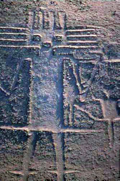
The Atacama Giant is an anthropomorphic geoglyph on the Cerro Unitas area of the Atacama Desert, Chile. At about 119 meters (390 feet), is the largest prehistoric anthropomorphic geoglyph. It has been suggested that the petroglyph represents a shaman, spiritual figure or deity, but there is little evidence to corroborate these claims.
The figure was an early astronomical calendar for knowing where the moon would set; by knowing this the day, crop cycle, and season could be determined. The points on the top and side of the head would say what season it would be depending on their alignment with the moon, which was important in determining when the rainy season would come in the barren Atacama.
The Atacama Giant is one out of nearly 5,000 geoglyphs - ancient artwork that is drawn into the landscape - that have been discovered in the Atacama region in the last three decades. It is believed that they are the work of several successive cultures that dwelt in this region of South America, including the Tiwanaku and Inca.
Atacama surprise: The world's driest desert is teeming with hidden life Science Daily - March 2, 2026
Even in the ultra-dry Atacama Desert, tiny soil-dwelling nematodes are thriving in surprising diversity. Scientists found that biodiversity increases with moisture and altitude shapes which species survive. In the most extreme zones, many nematodes reproduce asexually � a possible survival advantage. The discovery suggests that life in arid regions may be far richer, and more fragile, than once believed.
Hidden Life in the World's Driest Desert - Atacama Desert of Chile - Defies All Expectations SciTech Daily - January 18, 2026
Life beneath the surface of one of the driest places on Earth may be far more complex than once believed. Researchers have found that soil can support surprisingly robust and varied forms of life even in environments marked by extreme dryness.
Defying physics: Deep in Chile's Atacama Desert, scientists studied a green crystal called atacamite - and discovered it can cool itself dramatically when placed in a magnetic field Science Daily - July 6, 2025

Unlike a regular fridge, this effect doesn't rely on gases or compressors. Instead, it's tied to the crystal's unusual inner structure, where tiny magnetic forces get tangled in a kind of 'frustration'. When those tangled forces are disrupted by magnetism, the crystal suddenly drops in temperature. It�s a strange, natural trick that could someday help us build greener, more efficient ways to cool things.
Residents of the world's driest desert, the Atacama in northern Chile, woke up Thursday to a jaw-dropping spectacle: its famous lunar landscape blanketed in snow. PhysOrg - June 27, 2025

The observatory added that while snow is common on the nearby Chajnanator Plateau, situated at over 5,000 meters and where its gigantic Rubin Telescope is situated, it had not had snow at its main facility in a decade.
Strong M6.4 earthquake hits Atacama, Chile Watchers - June 7, 2025

This area is characterized by remote desert expanses and sparse population. 163,000 people are estimated to have felt moderate shaking, and 83,000 light. Overall, the population in this region resides in structures that are resistant to earthquake shaking, though vulnerable structures exist. Chile lies along the seismically active boundary where the Nazca Plate subducts beneath the South American Plate, making this region prone to earthquakes.
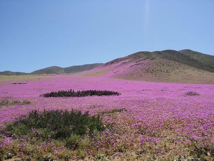
Unusual rainfall brings winter flowers to Chile's Atacama desert IFL Science - July 11, 2024

A Dark Secret Lies In The Atacama Desert IFL Science - July 22, 2023
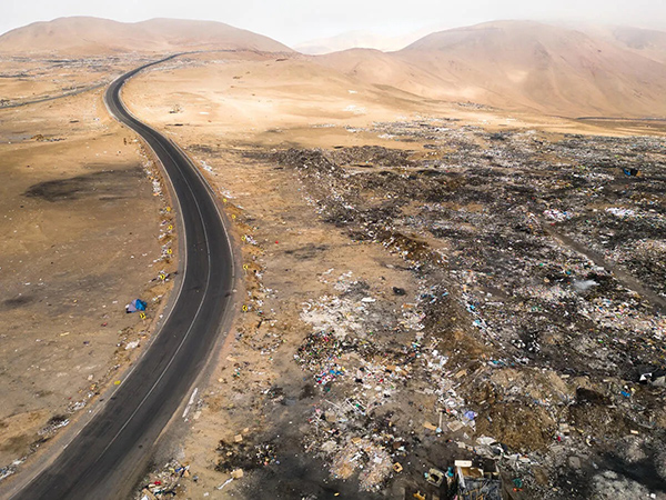
Deep in Chile�s Atacama Desert, there lies an ugly monument to fast fashion and cheap online clothing stores: piles upon piles of unsold clothing mounting like synthetic sand dunes.
Chile's Atacama Desert is the sunniest spot on Earth, catching as many rays as Venus Live Science - July 22, 2023
While normally cold and dry, this sunny swath, which sits at an elevation of roughly 13,120 feet (4,000 meters), gets more sunlight than places that are closer to the equator or at a higher elevation
Understanding rare rain events in the driest desert on Earth - Atacama Desert in northern Chile PhysOrg - January 18, 2022
In the enduring dryness of the Atacama Desert in northern Chile where the average rainfall is as low as 5 millimeters per year, rare rain events can come swiftly and intensely. They shape the landscape and provide precious moisture to plants and other species that otherwise adapted to extended dry spells or harvesting coastal fog. Intense rain events like those seen in the Atacama are known to be associated with so-called moisture conveyor belts, which are high-altitude atmospheric phenomena known for transporting large volumes of water vapor. However, whether or not moisture conveyor belts are responsible for the Atacama's intense rain events has yet to be shown.
The first rains in centuries in the Atacama Desert devastate its microbial life PhysOrg - November 15, 2018
The Atacama Desert, the driest and oldest desert on Earth, located in northern Chile, hides a hyper-arid core in which no rain has been recorded during the past 500 years. But this situation has changed in the last three years. For the first time, rainfall has been documented in the hyper-arid core of the Atacama, and contrary to what was expected, the water supply has caused a great devastation among local life. Contrary to what could be expected intuitively, the never-before-seen rainfall has not triggered a flowering of life in Atacama, but instead, the rains have caused enormous devastation in the microbial species that inhabited the region before the heavy precipitations
Earth's driest desert once had lakes BBC - December 16, 2016
The driest desert on Earth may once have had lakes and wetlands, scientists report. They have found the remnants of freshwater plants and animals buried in the arid plains of Chile's Atacama Desert. This watery period dates to between 9,000 and 17,000 years ago.
In Images: Stunning Flower Fields of the Atacama Desert Live Science - October 30, 2015
The normally barren, almost Martian landscape of the Atacama Desert recently erupted in flowers, painting the hillsides, blue, fuschia, orange and yellow. The almost magical transformation occurred thanks to heavy rains earlier in the year, which watered flower seeds that had lain dormant for years. Earlier in the year, the Atacama Desert received heavy rains, with the town of Antofagasta, Chile receiving seven years' worth of rain in a 12-hour span. Those heavy rains turned the parched desert into rivers of mud. But the same rainfall watered seeds that had been buried in the ground for years, waiting for their chance to bloom. Here, photos of the blooms painting the landscape.
Solved? Mystery of Atacama Desert's 'White Gold' Live Science - February 6, 2014
The driest, highest desert on Earth, Chile's Atacama Desert, also holds the world's richest nitrate and iodine deposits. As such, a "white gold" rush there fueled Europe's bombs in World War I and helped raise IQs once iodine deficiency was discovered. But even after the nitrate mines closed in the 1930s, the source of the massive mineral drifts remained a mystery. Glowing white as they bake on the sere desert surface, the Atacama nitrates are like nothing else in the world. These are weird deposits that, from a geological perspective, shouldn't be there. Nitrogen is abundant in the Earth's atmosphere but is highly depleted in the Earth's crust. Therefore, the giant nitrate deposits of the Atacama Desert are one of the most extraordinary, yet enigmatic mineral occurrences on Earth.
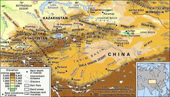
The Taklamakan Desert, also known as Taklimakan and Teklimakan, is a desert in in the southwest portion of the Xinjiang Uyghur Autonomous Region in northwest China. It is bounded by the Kunlun Mountains to the south, the desert Pamir Mountains and Tian Shan (ancient Mount Imeon) to the west and north, and the Gobi Desert to the east. The name is probably an Uyghur borrowing of Arabic tark, "to leave alone/out/behind, relinquish, abandon" + makan, "place". Another plausible explanation is that it is derived from Turki taqlar makan, which means "the place of ruins". Popular accounts claim that Takla Makan means "go in and you will never come out". It may also mean "The point of no return" or "The Desert of Death". The Taklamakan Desert Ecoregion is a Chinese ecoregion of the Deserts and xeric shrublands Biome.
There is very little water in the desert and it is hazardous to cross. Merchant caravans on the Silk Road would stop for relief at the thriving oasis towns. The key oasis towns, watered by rainfall from the mountains, were Kashgar, Marin, Niya, Yarkand, and Khotan (Hetian) to the south, Kuqa and Turpan in the north, and Loulan and Dunhuang in the east. Now many, such as Marin and Gaochang, are ruined cities in sparsely inhabited areas in the Xinjiang Autonomous Region of the People's Republic of China.
The archeological treasures found in its sand-buried ruins point to Tocharian, early Hellenistic, Indian, and Buddhist influences. Its treasures and dangers have been vividly described by Aurel Stein, Sven Hedin, Albert von Le Coq, and Paul Pelliot.

Mummies, some 4000 years old, have been found in the region. They show the wide range of peoples who have passed through. Later, the Taklamakan was inhabited by Turkic peoples. Starting with the Tang Dynasty, the Chinese periodically extended their control to the oasis cities of the Taklamakan in order to control the important silk route trade across Central Asia. Periods of Chinese rule were interspersed with rule by Turkic, Mongol and Tibetan peoples. The present population consists largely of Turkic Uyghur people.
Researchers narrow birth estimate for the Takliman Desert PhysOrg - June 12, 2015
The second largest sand sea in the world, the Takliman Desert in central Asia influences geology, the global climate, and has even shaped the development of global human culture - the two branches of the Silk Road along its southern boundary were shaped by the need to avoid its vast, arid wastes.
Secret Ancient World Buried Under The Vast Taklimakan Desert February 27, 2013
Ancient people believed that once you entered this place there was no way out. A very long time ago, there were houses and temples here. Today, everything is buried under the sand. Precious ancient relics are hidden deep under the "Sea of Death", or the Takla Makan desert. Archaeologists are beginning to discover some of the secrets that have been hidden in this mysterious region. Still, it seems that we are only scratching the surface and only time will tell what more wonders are waiting to be unraveled. The Taklamakan desert is the largest desert in China and it is also considered to be the world's second largest shifting-sand desert covering an area of over 33, 700 square kilometers (over 13,000 square miles). In Uigur language, Takla Makan means 'you can get into it but can never get out' and that is why the desert is also called the Sea of Death.
The desert is very significant to the people in this region. According to an ancient legend, once a long time ago, a powerful Supernatural Being who saw the hardship being faced by the people in this area, thought that he could help them by using the two magic objects in his possession namely the golden axe and the golden key. He gave his golden axe to the Kazakh, so they split the mountain Altai and diverted water from the mountains to the fields. The Supernatural Being planned to give the golden key to the Uigur so that they could open the door of the treasure-house of the Tarim Basin, but unfortunately his youngest daughter lost the key. This angered him so much that he held her a captive in the Tarim Basin and thus the Takla Makan Desert was formed.
In more modern times, historians learned that the Takla Makan desert played a vital business role. There are oases located on two routes around the desert that served as important trading spots on the so-called Silk Road. Of all the precious goods crossing this area, silk was perhaps the most remarkable for the people of the West. In 1896, Swedish explorer Sven Hedin made a surprising discovery at the oasis town of Dandan Oilik, in the heart of the Taklimakan Desert.
Sven Hedin found many remains of houses. Then Aurel Stein, another explorer known as a pioneer of the Silk Road, stayed there for two weeks, and found the remains of another 18 residential houses and identified some temples. He also found documents from the Tang and Han dynasties. In 1900, Hedin once again visited the Taklimakan. In this expedition, he found the ruins of the ancient city Loulan, buried under the sand. The ancient city of Loulan is the capital of the Loulan kingdom, which dates back even further than Dandan Oilik. These two discoveries, Dandan Oilik and Loulan, are signature archeological events in Xinjiang. In 1910, ten years after Loulan was found, a local hunter discovered a tomb near a creek 175 kilometers away from Loulan. It was named the 'creek tomb'. Built using more than 100 wooden poles erected on a sand dune, the tomb is regarded as one of the most intriguing mysteries in ancient Asian civilization.
It belongs to the early bronze age, whose history in Xinjiang stretches back to 4,000 years ago. Half a century later, in 1979, a female corpse dating back nearly 4,000 years was discovered in Loulan. The corpse was well preserved, and nicknamed the "Beauty of Loulan".

In 1995, ancient brocade appraised as made in Sichuan province during the Han dynasty, was found at Niya ruin in the south of the Taklimakan Desert. It became one of the top archeological finds that year. In 2003, during a dig at the creek tomb, another well-kept female corpse was found. Also estimated at over 4,000 years old, the corpse still had beautiful facial features, thick eyelashes, and a visible smile. Her beauty once again stunned the world, 24 years after the discovery of Loulan beauty. A funeral system involving reproduction worship was also revealed. Who inhabited this region and what contact did they have with the European continent?

A Tocharian man with red-blond hair; his clear European features still visible after nearly 3,500 years in his desert grave in Taklamakan. In the late 1980's, several well-preserved mummies were discovered in the Takla Makan desert. The perfectly well-preserved mummies are estimated to be at least 3000 years-old. The corpses reveal that the people had long reddish-blond hair, European features and didn't appear to be the ancestors of modern-day Chinese people. Archaeologists now think they may have been the citizens of an ancient civilization that existed at the crossroads between China and Europe It would seem an entire secret ancient world is hidden beneath the sand.

Mummies

Ancient China
Strange Yellow Glass in African Desert Traced Back to Extraterrestrial Impact. The Great Sand Sea Desert stretches over an area of 72,000km linking Egypt and Libya Science Alert - November 22, 2023
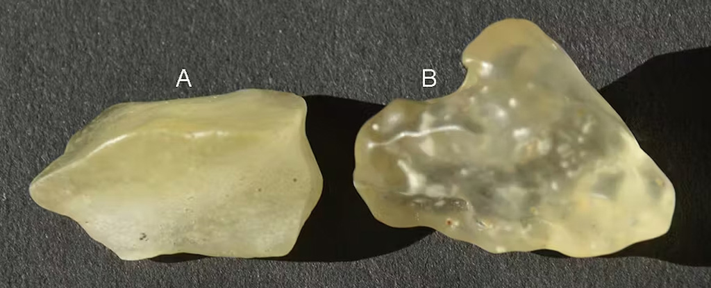
If you find yourself in a particular part of the desert in south-east Libya and south-western parts of Egypt, you'll spot pieces of yellow glass scattered across the sandy landscape. It was first described in a scientific paper in 1933 and is known as Libyan desert glass. Mineral collectors value it for its beauty, its relative rarity - and its mystery. A pendant found in Egyptian pharaoh Tutankhamun's tomb contains a piece of the glass.
Steamy Stuff At Fly Ranch Geyser IFL Science - September 27, 2023
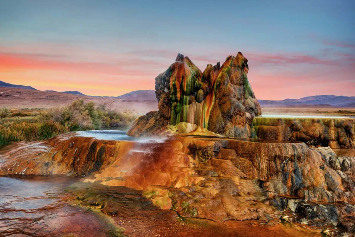
The colorful pic of Fly Ranch Geyser in Nevada is the result of thermophilic algae and mineral deposits. The other-worldly environment sits on the edge of Black Rock Desert.
Dune patterns reveal environmental change on Earth and other planets PhysOrg - August 3, 2023
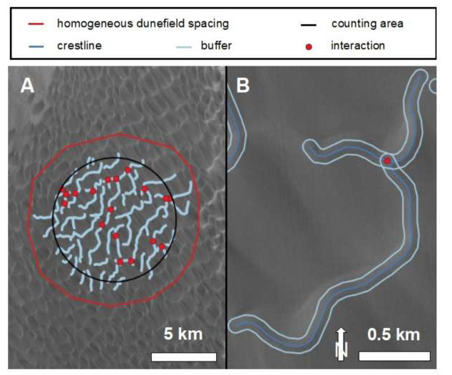
Dunes, the mounds of sand formed by the wind that vary from ripples on the beach to towering behemoths in the desert, are incarnations of surface processes, climate change, and the surrounding atmosphere. For decades, scientists have puzzled over why they form different patterns.
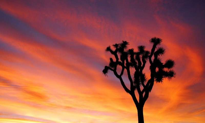
Joshua trees burn, massive wildfire threatens to forever alter Mojave Desert PhysOrg - August 2, 2023
California's largest wildfire of the year has grown to over 80,000 acres in the desert around the Nevada border, burning primarily in the national preserve. Aided by brief rain, crews made the first real inroads against the blaze. Recovery is really not a meaningful term in the desert because of the global climate changes.
Rare snow and hailstorms cover Saudi desert CNN - January 21, 2022
For most people, thinking about the Saudi Arabian desert probably conjures up images of sand dunes baked by relentless sunshine. More recently, however, those sands have been covered in snow. Several recent snow and hailstorms in the region have transformed landscapes in and around Saudi Arabia, stirring excitement among locals and causing a sensation on social media. Earlier this month, Saudi photographer Osama Al-Habri captured aerial images of Badr Governorate, southwest of the Islamic pilgrimage city of Medina, dressed in white as locals gathered to enjoy the unusual sight.
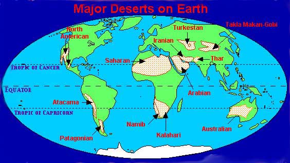
List of Earth's Deserts