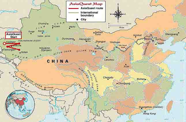
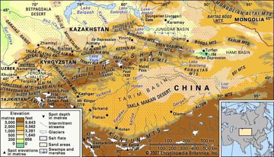
The Taklamakan Desert (also Taklimakan) is a desert of Central Asia, in the Xinjiang Uyghur Autonomous Region of the People's Republic of China. It is known as one of the largest sandy deserts in the world. It covers an area of 270,000 km2 of the Tarim Basin, 1,000 km long and 400 km wide. It is crossed at its northern and at its southern edge by two branches of the Silk Road as travellers sought to avoid the arid wasteland.
The Taklamakan Desert is one the world's major deserts, ranking 15th in size in a ranking of the world's largest non-polar deserts.
There is no water on the desert and it was hazardous to cross. Takla Makan means go in and you'll never come out? Merchant caravans on the Silk Road would stop for relief at the thriving oasis towns. The key oasis towns, watered by rainfall from the mountains, were Kashgar, Marin, Niya, Yarkand, and Khotan (Hetian) to the south, Kuqa and Turfan in the north, and Loulan and Dunhuang in the east. Now many, such as Marin and Gaochang are ruined cities in sparsely inhabited dusty spots with poor roads and minimal transportation in the Xinjiang Autonomous Region of the Peoples Republic of China.
The archeological treasures found in its sand buried ruins point to Tocharian, early Hellenistic, Indian and Buddhistic influences.
Mummies, some 4000 years old, have been found in the region. They show the wide range of peoples who have passed through. Some of the mummies appear European. Later, the Taklamakan was inhabited by Turkic peoples. Starting with the Tang Dynasty, the Chinese periodically extended their control to the oasis cities of the Taklamakan in order to control the important silk route trade across Central Asia. Periods of Chinese rule were interspersed with rule by Turkic and Mongol and Tibetan peoples. The present population consists largely of Turkic, Uyghur and Kazakh people.
The vast majority of rivers on the planet flow in a southerly direction because the source (usually in the mountains) is to the north of the mouth of the river. If the source of a river is at a higher elevation than the mouth, that river will run from the source to the mouth. However, if that (higher) source is to the south of the mouth, that river will then flow to the north (downhill).
Mysterious Grid Patterns in China's Deserts Explained Live Science - November 3, 2012
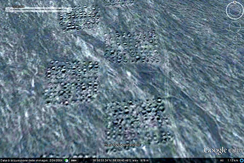
A mysterious grid of dots spanning several miles of Western China's sand dunes like a giant chessboard may be the result of geological surveys for nickel mines, according to new analysis of satellite images of the area. "In the satellite maps, we can see a man-made texture on the soil, a huge band which seems created by relatively small holes or mounds," wrote the study author, Amelia Carolina Sparavigna, a physicist at Italy's Polytechnic University of Turin, on Oct. 25 on the website arXiv.org, ahead of publication to a scientific journal. "This curious texture on the desert soil was probably produced by the pinpointing of geophysical research."
In 2010, Sparavigna started investigating Google Earth satellite images of China's remote Taklamakan desert to study the textures carved into the sand dunes by the wind. In the process, the amateur archaeologist found possible paths around the ruins of an ancient Silk Road Kingdom called Loulan. For more than a thousand years, a sea of caravans laden with spices, silks and other Eastern goods passed through this arid outpost on the way to Europe.
The strange pattern was clearly man-made. In older imagery from Bing and Nokia Maps taken prior to 2004, the strange pattern wasn't visible, indicating the shapes appeared more recently. Sparavigna then found an article in the Chinese press describing the discovery of large amounts of nickel buried under the dunes. She concluded the new shapes must be evidence of geological surveying done prior to mining the nickel reserves. Geologists often drill boreholes to determine the composition of mineral deposits below the surface.
This isn't the first time Sparavigna has analyzed satellite imagery to shed light on mysterious patterns. In 2011 she discovered strange patterns she claimed were geoglyphs in Peru, and has also weighed in on the symbolic meaning of Chinese army barracks from the 1960s. Sparavigna thinks it may be a good idea to create a database of large-scale, man-made features like these throughout the world. In her opinion, it can anticipate mining activity and development of a region
Taklamakan Desert