An arcus cloud is a low, horizontal cloud formation associated with the leading edge of thunderstorm outflow, or occasionally with a cold front even in the absence of thunderstorms. Roll clouds and shelf clouds are the two types of arcus clouds, slight variations in their generation and appearance being the difference. Cool, sinking air from a storm cloud's downdraft spreads out across the surface with the leading edge called a gust front. This outflow undercuts warm air being drawn into the storm's updraft. As the cool air lifts the warm moist air, water condenses creating a cloud which often rolls with the different winds above and below (wind shear).
A sharp, strong gust front will cause the lowest part of the leading edge of an arcus to be ragged and lined with rising fractus clouds. In a severe case there will be vortices along the edge with twisting masses of scud that may reach to the ground or be accompanied by rising dust. A very low shelf cloud accompanied by these signs is the best indicator that a potentially violent wind squall is approaching. An extreme example of this phenomenon looks almost like a tornado and is known as a gustnado. Read more ...
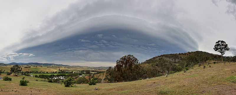
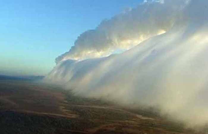
A shelf cloud is a low, horizontal, wedge-shaped arcus cloud. A shelf cloud is attached to the base of the parent cloud, which is usually a thunderstorm, but could form on any type of convective clouds. Rising cloud motion often can be seen in the leading (outer) part of the shelf cloud, while the underside often appears turbulent and wind-torn. Cool, sinking air from a storm cloud's downdraft spreads out across the land surface, with the leading edge called a gust front. This outflow cuts under warm air being drawn into the storm's updraft. As the lower cooler air lifts the warm moist air, its water condenses, creating a cloud which often rolls with the different winds above and below (wind shear). People seeing a shelf cloud may believe they have seen a wall cloud. This is likely a mistake, since an approaching shelf cloud appears to form a wall made of cloud. A shelf cloud usually appears on the leading edge of a storm, and a wall cloud will usually be at the rear of the storm.
A sharp, strong gust front will cause the lowest part of the leading edge of a shelf cloud to be ragged and lined with rising fractus clouds. In a severe case there will be vortices along the edge, with twisting masses of scud that may reach to the ground or be accompanied by rising dust. A very low shelf cloud accompanied by these signs is the best indicator that a potentially violent wind squall is approaching. An extreme example of this phenomenon looks almost like a tornado and is known as a gustnado.
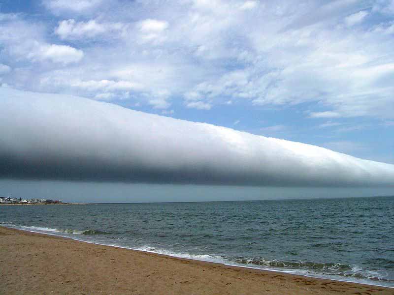
Giant Tubular Cloud Rolling Across the Sea
Live Science - March 5, 2012This roll cloud photo was taken by Capt. Andreas M. van der Wurff from a ship en route from Paranagua, Brazil, to Montevideo, Uruguay, on Feb. 6. A photo taken near Brazil captures a rare and beautiful "roll cloud," a tubular cloud that seems to tumble across the sky. The spectacular photo, captured last month, was just released by NASA's Earth Science Picture of the Day blog.Roll clouds are a type of arcus cloud, which is a category of low cloud formations. Their more common cousin is the shelf cloud, often seen on the leading edges of thunderstorms. Roll clouds sometimes form along with storms, too, born out of the storm's downdraft. Sinking cold air causes warm, moist air on the planet's surface to climb to higher altitudes, where the moisture condenses into cloud form. Winds from the storm "roll" the cloud parallel to the horizon, creating an effect that looks much like a horizontal tornado. Unlike shelf clouds, rolls clouds are completely detached from the bulk of the storm.
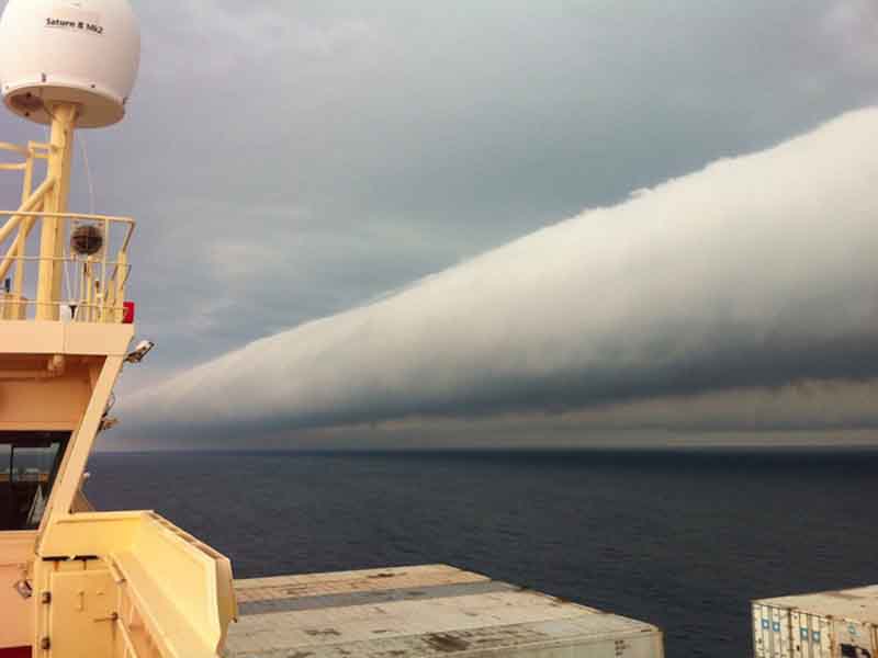
Roll Cloud Over Wisconsin
NASA - August 31, 2011What kind of cloud is this? A type of arcus cloud called a roll cloud. These rare long clouds may form near advancing cold fronts. In particular, a downdraft from an advancing storm front can cause moist warm air to rise, cool below its dew point, and so form a cloud. When this happens uniformly along an extended front, a roll cloud may form. Roll clouds may actually have air circulating along the long horizontal axis of the cloud. A roll cloud is not thought to be able to morph into a tornado. Unlike a similar shelf cloud, a roll cloud is completely detached from their parent cumulonimbus cloud. Pictured above, a roll cloud extends far into the distance as a storm approached in 2007 in Racine, Wisconsin, USA.
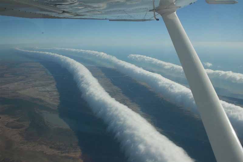
Morning Glory Clouds Over Australia
NASA - August 24, 2009What causes these long, strange clouds? No one is sure. A rare type of cloud known as a Morning Glory cloud can stretch 1,000 kilometers long and occur at altitudes up to two kilometers high. Although similar roll clouds have been seen at specific places across the world, the ones over Burketown, Queensland Australia occur predictably every spring. Long, horizontal, circulating tubes of air might form when flowing, moist, cooling air encounters an inversion layer, an atmospheric layer where air temperature atypically increases with height. These tubes and surrounding air could cause dangerous turbulence for airplanes when clear. Morning Glory clouds can reportedly achieve an airspeed of 60 kilometers per hour over a surface with little discernible wind. Pictured above, photographer Mick Petroff photographed some Morning Glory clouds from his airplane near the Gulf of Carpentaria, Australia.
New phenomenon found in internal waves PhysOrg - April 28, 2010
Internal waves -- huge but nearly invisible ripples that occur in the oceans, the atmosphere and stars ... Morning Glory clouds in Australia are one example of internal waves in the atmosphere. Internal waves are huge but nearly invisible ripples that occur in the oceans, the atmosphere and stars -- can play an important role in climate change and other processes, but there is plenty about them that remains to be understood. In a significant new finding, however, MIT researchers have discovered that such waves can be analyzed using the same techniques physicists have developed to study the passage of light.
There's a direct mathematical connection between how these waves travel in the ocean and the atmosphere, and the classical properties of an optical interferometer. Optical interferometers use a pair of partially reflecting parallel mirrors to selectively block or transmit specific wavelengths of light, a technique widely used in fiber-optic communications systems, lasers and astronomical instruments. The method works because the beam of light is reflected back and forth between the two mirrors, and depending on the precise spacing between the mirrors the light beams that emerge at the other side will either reinforce each other (if the peaks of the waves match up) or weaken each other (if the peak of one wave lines up with the trough of another). Because the optical method is well studied and understood, this new insight should make it easier for researchers to probe the mysteries of internal waves in the air and sea. It also could enhance the accuracy of global climate models by helping scientists understand where the energy and momentum carried by such waves is deposited in the oceans.
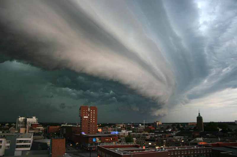
A shelf cloud is a low, horizontal wedge-shaped arcus cloud. Unlike a roll cloud, a shelf cloud is attached to the base of the parent cloud (usually a thunderstorm). Rising cloud motion often can be seen in the leading (outer) part of the shelf cloud, while the underside often appears turbulent and wind-torn. Occasionally people seeing a shelf cloud may believe they have seen a wall cloud. This is a common mistake, since an approaching shelf cloud appears to form a wall made of cloud. Generally speaking, a shelf cloud appears on the leading edge of a storm, and a wall cloud will usually be at the rear of the storm.
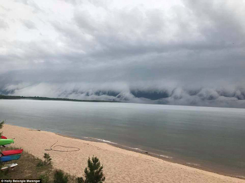
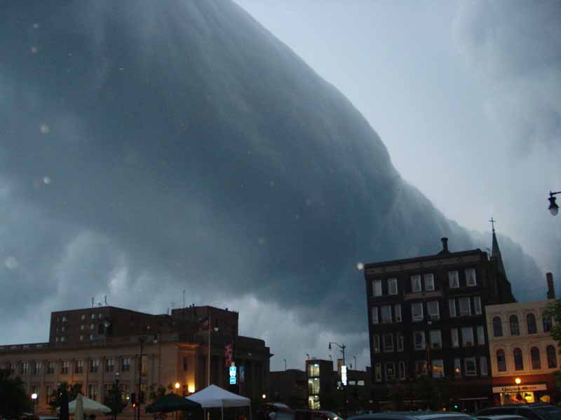
Rare 'shelf cloud' appears like an apocalyptic nightmare as it slowly creeps
towards the shore in new footage from Michigan resort
Giant tsunami-like shelf cloud caught on camera rolling over lake in Michigan CBS - July 2, 2018
A weather phenomenon that was caught on camera in Au Train, Michigan, looked like a giant tsunami rolling in from the ocean. But it was really a shelf cloud rolling over Lake Superior, CBS affiliate KEYE-TV reports. The ominous cloud stayed close to the lake water, sucking up moisture and growing bigger as it moved toward shore. Holly Belongie Marenger caught the weather event on camera. Marenger said it was about 85 degrees, but the presence of the shelf cloud made the temperature drop, and created an eerie effect over the lake.
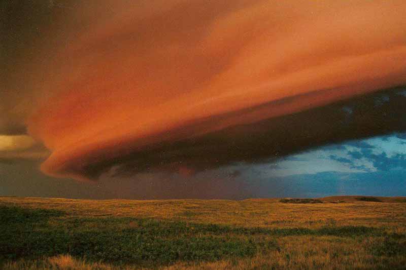
Shelf Cloud Over Saskatchewan
NASA - January 22, 2008Shelf clouds are typically seen leading thunderstorms, although they may precede any well defined front of relatively cold air. Shelf clouds differ from roll clouds because shelf clouds are attached to a larger cloud system lurking above. Similarly, shelf clouds differ from wall clouds because wall clouds typically trail storm systems. The above pictured shelf cloud was photographed toward the southwest during a trip crossing the prairies of Saskatchewan, Canada on the Trans-Canada Highway in 2001 August. A rising Sun illuminated the impressive cloud from the east as it advanced from the west.