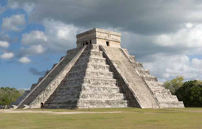
Chichen Itza

Chichen Itza is a large pre-Columbian archaeological site in Yucatan, Mexico built by the Maya civilization. The Maya name "Chich'en Itza" means "At the mouth of the well of the Itza (people)". Although this was the usual name for the site in pre-Columbian times, it is also referred to in the ancient chronicles as Uucyabnal, meaning "Seven Great Rulers". Chichen" contains many fine stone buildings in various states of preservation; the buildings were formerly used as temples, palaces, stages, markets, baths, and ballcourts.


Mayan Pyramid of Kukulkan - The Castle


Mayan Pyramid of Kukulkan

Dominating the center of Chichen is the Temple of Kukulcan (the Maya name for Quetzalcoatl), often referred to as El Castillo (the castle). This step pyramid with a ground plan of square terraces with stairways up each of the 4 sides to the temple on top.

Great sculptures of Plumed Serpents run down the sides of the northern staircase, and are set off by shadows from the corner tiers on the Spring and Fall equinox. It was practice in Mesoamerican cities to periodically build larger and grander temple pyramids atop older ones, and this is one such example.

Thanks to archeologists, a doorway at the base of the north stairway leads to a tunnel, from which one can climb the steps of the earlier version of El Castillo inside the current one, up to the room on the top where you can see King Kukulcan's Jaguar Throne, carved of stone and painted red with jade spots.

Built into one of the exterior walls of the ballcourt is the Temple of the Jaguar, which features another jaguar throne since this one was not buried for a thousand years, its red paint and jade spots are long since gone. Behind this platform is a walled inscription which depicts a tzompantli (rack of impaled human skulls) in relief.

The Temple of the Warriors

The 'Temple of the Warriors' and its adjacent 'Temple of the Jaguar' are very impressive ruins of the complex. A massive temple structure, surrounded by hundreds of columns is carved with reliefs. The columns continue on into the jungle, that part of the temple still has not been restored.

The Observatory - Carocal

This celestial observatory denotes seasons based on solar alignment at different times of the year.

The Nunnery

The Mayans were great sportsmen and build huge ballcourts to play their games. The Great Ballcourt of Chichén Itzá is 545 feet long and 225 feet wide overall. It has no vault, no discontinuity between the walls and is totally open to the sky. As we approach a silent sentinel stands guard.


Ball Court Temple

Each end has a raised "temple" area. A whisper from end can be heard clearly at the other end 500 feet away and through the length and breath of the court. The sound waves are unaffected by wind direction or time of day/night. Archaeologists engaged in the reconstruction noted that the sound transmission became stronger and clearer as they proceeded. In 1931 Leopold Stokowski spent 4 days at the site to determine the acoustic principals that could be applied to an open-air concert theater he was designing. Stokowski failed to learn the secret. To this day it has not been explained.

Archaeological study of chirped echo from the Mayan pyramid
of Kukulkan - Quetzalcoatl at Chichen Itza

The massive Kukulcan pyramid called 'El Castillo' - the castle - is roughly at the center of the site. Climbing it is quite a challenge and those who make it are rewarded with a spectacular view of the city and surrounding country side. Inside the pyramid, the corridors and chambers are hot and humid.

Handclaps evoke chirped echoes from the staircases of the Pyramid of Kukulkan at Chichen Itza. The physics of the chirped echo can be explained quite simply as periodic reflections from stepfaces. The chirped echo sounds much like the primary call of the Mayan sacred bird, the resplendent Quetzal.


Quetzal Bird

This magnificent bird, now near extinction, has for thousands of years represented the 'spirit of the Maya'. Spirits, in many traditions, speak in echoes, lacking a body, just pure spirit.

A Mayan glyph from the Dresden Codex makes the connection between the pyramid of Kukulkan and the Quetzal bird. This glyph shows Kukulkan/Quetzalcoatl , the "sovereign plumed serpent" with a gigantic Quetzal behind him. The Quetzal bird may have represened the spirit of the Maya. Spirits often speak in echoes. It therefore seems most appropriate that the spirit echo of the Pyramid of Kukulkan would speak in the echo-voice of the Quetzal.

Today the Quetzal plays an important part in modern Mayan culture. Many modern Maya live in Guatemala, and in the Mexican States of Chiapas and Quintan Roo. The Quetzal is the unit of currency in Guatemala. The Guatemalan government issues a prestigious award named "The Order of the Quetzal." Could the Maya have intentionally coded the sound of their sacred bird into the pyramid architecture?

In the millenium since this pyramid was built, though the plaster has eroded from the limestone staircases, the sound is still recognizable.


Language of the Birds - God Language


Tzintzuntzan

Tzintzuntzan is a city in the state of Michoacan, Mexico. It stands on the eastern shore of Lake Pátzcuaro, about 15 km north of the city of Patzcuaro and about 60 km west of state capital Morelia, and at some 2050 m above sea level. It serves as the administrative seat for the surrounding municipality of the same name and, in the 2000 census, reported a population of 3,610 people.

The city was founded in the 13th century by the Native American Tarascan or Purepecha nation, in whose language the name means "Place of the Hummingbirds".

In the last years of the 15th century it became the capital of the Tarascan league, replacing nearby Ihuatzio. During this time the Purepecha successfully repulsed an invasion by the Aztecs.

The Pre-Columbian city of Tzintzuntzan covered an area of about 7 kms. The site, which stands on a hillside above the modern town, has the remains of many step pyramids of a design typically used by the Purepecha in their ritual buildings, known locally as yacatas (by extension, the present-day archaeological site is also known as "Las Yacatas").

The Tzintzuntzan yacatasare of several different shapes, some rectangular, some oval or circular, and others in the distinctive Tarascan "T" shape. The population of the ancient city is estimated to have peaked at somewhere between 25,000 to 35,000 people.

Tzintzuntzan was still the Tarascan capital when the Spaniards arrived in 1522. First contact, led by Cristubal de Olid, was peaceful, but when a second Spanish expedition led by Nuno de Guzman arrived in 1529, Chieftain Tanganxoan was burned alive and the city largely dismantled to provide stones for Roman Catholic temples and civic buildings, most notably the large 16th century Franciscan Monastery of Santa Ana. Following the disgrace and recall of Nuno de Guzman, Vasco de Quiroga was sent to the region, and Tzintzuntzan served as the headquarters of Spanish power in the area until the bishopric was relocated to Patzcuaro in 1540.

The modern town of Tzintzuntzan is known for the basketry and weaving produced there. The Monastery of Santa Ana is also still standing. It is home to several allegedly miraculous relics and icons and is reputed to have growing in its grounds what were the first olive trees to be planted in America.


Teotihuacanos

Teotihuacan was the largest-known pre-Columbian city in the Americas, and the name is also used to refer to the civilization this city dominated, which at its greatest extent included much of Mesoamerica.

The city was located in what is now the San Juan Teotihuacan municipality (population 44,653 as per 2000 census figures), in the State of Mexico, Mexico, approximately 40 km (about 25 miles) northeast of Mexico City at. It covers a total surface area of 82.66 kms.

The name Teotihuacan was given by the Aztec centuries after the fall of the city, and is translated as "the place where men became gods".

The original name of the city is unknown but recently the glyph that represents the city has been translated as "The place of the precious sacrifice".

There is archaeological evidence that Teotihuacan had been a multi-ethnic place, with distinct Zapotec, Mixtec, Maya and what seems to be Nahua quarters.

The Totonacs have always maintained that they were the ones who built it, a story that was corroborated later by the Aztecs. The city was also anciently referred to as Tollan, a name also used centuries later for the Toltec capital of Tula (Tollan Xicocotitlan in Nahuatl).

History

"Teotihuac·n" (teh-oh-tee-wah-kahn) is a Nahuatl name, translated as "city where men become gods." According to legend it was where the Gods gathered to plan the creation of man.


Pyramid of the Sun

Construction of Teotihuacan commenced around 300 BC, with the Pyramid of the Sun built by 150 BC. The city reached its zenith approx. 150-450 AD, when it was the center of an influential culture. At its height the city covered over 30 kms, and probably housed a population of over 150,000 people, possibly as many as 200,000.

Teotihuacan was an important source of obsidian and there was extensive trade with other regions of Mesoamerica.

The city's broad central avenue, called "Avenue of the Dead" (a translation from its Nahuatl name Miccaohtli), is still flanked by impressive ceremonial architecture, including the immense Pyramid of the Sun (second largest in the New World after the Great Pyramid of Cholula), the Pyramid of the Moon, the Temple of Quetzalcoatl or Temple of the Feathered Serpent, and many lesser temples and palaces.

The "Pyramid of the Sun" was in reality dedicated to Tlaloc, the god of rain, and was built over a cave, most likely a sacred cave. Unfortunately the cave content was stolen, possibly in Pre-Columbian times.

Pyramid of the Moon

The "Pyramid of the Moon" was dedicated to Tlaloc's consort Chalchihuitlicue, goddess of lakes and streams, and was used also as a burial site for important people.

The Moon Pyramid is located at the northern end of the Avenue of the Dead, which was the main axis of the city. The pyramid, facing south, was built as the principal monument of the Moon Pyramid complex. The five-tiered platform was attached to the front of the Moon Pyramid. It is said that the present pyramid has interior structures within it. However, the pyramid still remains as one of the least understood major monuments in Teotihuacan.

The city was highly planned symmetrically and was integrated into the local geography. This may be realized by standing on the center line of the Avenue of the Dead, namely on the main axis of the city.

The top of mountain Cerro Gordo dominating the background of the Moon Pyramid exactly coincides at a certain point of the avenue with the top of the pyramid - a pan-Mesoamerican notion that the pyramid represents a sacred mountain seems to have been an integral element of the city plan. The Avenue of the Dead begins at the Moon Plaza, which was surrounded by 15 pyramidal structures including the Moon Pyramid.

The Quetzalpapalotl Palace lies immediately to the southwest of the Moon Plaza. Like the Main Plaza in the Ciudadela, the Moon Plaza seem to have been one of the main ritual precincts of the city.

Unfortunately no ancient Teotihuacano non-ideographic texts are known to exist (or known to have existed), but the city is occasionally referred to in the texts of Maya monuments, showing that Teotihuacan nobility travelled to and married with the families of local rulers as far away as Honduras.

Maya hieroglyphs mention an individual nicknamed by scholars as Spearthrower Owl, apparently Emperor of Teotihuacan, who reigned for over 60 years and imposed his relatives as kings of Tikal and Uaxactun in Guatemala. Most of what we infer about the culture at Teotihuacan comes from the murals that adorn the site and others, like the Wagner Murals, found in private collections.

It was previously believed that sometime during the 7th or 8th centuries, the city was sacked and burned by invaders, possibly the Toltecs. More recent evidence, however, seems to indicate that the burning was limited to the structures and dwellings associated primarily with the elite class. The slums and poorer districts were almost untouched.

Many now claim this is evidence that the burning was from an internal uprising and that the invasion theory is flawed due to the fact that early archaeological work on the city was focused exclusively on the palaces and temples, places used by the elites, and because all of these sites showed burning.

Archaeologists concluded that the whole city was burned. Instead, it is now known that the destruction in the city was focused on the power symbols: Some statues seem to have been destroyed in a methodical way, their fragments dispersed. The fact that population began to decline around 500-600 CE also supports the internal unrest hypothesis.

In rebuttal, advocates of the invasion hypothesis point to the mural paintings of Cacaxtla, a rival city, in which was found a battle painting featuring the glyph of Teotihuacan over a burning pyramid, the Mesoamerican symbol of a conquered city, which could mean that there really was an attack on Teotihuacan, led by Cacaxtla. However, it was not unknown for ancient rulers to falsely claim victory over foes.

Comparative Geometric Analysis of the Heights and Bases of the Great Pyramid of Khufu and the Pyramid of the Sun at Teotihuacan ...


Tula

Tula is a town of about 10,000 in Hidalgo State, central Mexico, some 100 km to the north-north-west of Mexico City. The modern town is known as Tula de Allende; it covers part of the south-eastern portion of the Pre-Columbian city.

Nearby are the remains of the ancient capital city of the Toltecs, also known as "Tula" or as "Tollan". Usually identified as the Toltec capital around 980 AD, the city was destroyed in or about 1168 or 1179.The site is at and around the junction of the Rio Rosas and the Rio Tula.

The two largest clusters of grand ceremonial architecture are nicknamed "Tula Grande" (the most visited by tourists) and "Tula Chico". Remains of other buildings extend for some distance in all directions. In the residential areas streets were laid out in a grid pattern.

The city was the largest in central Mexico in the 9th and 10th centuries, covering an area of some 12 kms with a population of at least some 30,000, possibly significantly more. While it might have been the largest city in Mesoamerica at the time, some Maya sites in the Yuctan may have rivaled its population during this period.

Distinctive Toltec features here include terraced pyramids, colonnaded buildings, and relief sculptures, including the characteristic chacmools, reclining figures that may have been avatars of the Rain God. There are two large courts for playing the Mesoamerican ballgame.

Some of the architecture is similar to that at Chichen Itza.The site was extensively looted in Aztec times, with much of the artwork and sculpture carted off.The first scholarly description of the ruins was made by Antonio GarcĚa Cubas of the Mexican Society of Geography and History in 1873.


El Tajin

El Tajín is a Pre-Columbian archaeological site near the city of Papantla, in the state of Veracruz, Mexico.

Construction of ceremonial buildings at El Tajín began about the 1st century. Early classic Tajín shows influence of Teotihuacan; early postclassic shows considerable Toltec influence. Construction continued to about the start of the 13th century, at which time the city was conquered and burned by Chichimec invaders. The site continued to be occupied after this by a smaller population, but no new large construction projects were initiated. The site was completely abandoned with the arrival of the Spanish conquerors in the early 16th century.

The abandoned site was overgrown with forest. In 1785 engineer Diego Ruiz visited the site and published the first description of the site. In the early 19th century it was visited by Guillermo Dupaix, Alexander von Humboldt, and Carlos Nebel, who published additional accounts.The first archeological excavation of the site was made by Jose Garcia Payon from 1943 through 1963. The Mexican Institute of Anthropology & History has made additional restoration to buildings at the site since the 1980s.

The ceremonial center of the site is covers only about 1 km square, but there are mostly unexcavated remains of subsidiary buildings extending for a considerable distance beyond.The ceremonial center has number of temple-pyramids, palaces, and several courts for playing the Mesoamerican ballgame.

The site's most famous building is the Pyramid of the Niches. The step pyramid of 6 terraces is some 60 feet high. The size is only medium as Mesoamerican pyramids go, but the architecture creates a striking and visually pleasing effect. The terraces are of well cut stone forming a series of 365 niches. A staircase rises up the pyramid's east side. Originally the pyramid was topped by a temple, but little remains of this.

A number of the buildings have carved relief on them, and the site also has some free standing stone stelae. Many of the sculptures depict the ritual ballgame and ritual bloodletting by the elite. The site is now a tourism destination, has a moderate sized museum.


Monte Alban

Monte Albán is a large archaeological site in the state of Oaxaca, Mexico, located at 17.02° N 96.45° W, elevation 1941 meters.The name "Monte Albán" means "White Mountain" in the Spanish language; the Zapotec name was Danipaguache, meaning "Sacred Mountain of Life".

The Aztecs knew it as Ocelotepec, or "Jaguar Mountain".

This sacred Mesoamerican city is on an artificially flattened mountain top some 400 meters above the city of Oaxaca.

Monte Albán was built over a period of over 2,000 years, starting about 900 BCE, by the Zapotec people. The early art shows Olmec influence. The most impressive building period was during the Mesoamerican Classic era, from about 550 CE to 1000 CE.

|About 1300 CE, the Zapotec were driven out of the site and surrounding area by the Mixtec people. The Mixtec made further additions to Monte Albán until they in turn were conquered by the Spanish Conquistadores in 1521, at which time Monte Albán was abandoned.

Monte Albán has many step-pyramids, temples, elite tombs, and a court for playing the Mesoamerican ballgame. There are also free-standing sculptured stelae, and large bas-relief carved panels in some of the buildings.

The oldest carved stones at the site are the so-called "Danzantes" (literally, dancers), featuring drawings of people in contorted and twisted poses. Although the notion that they depict a dance is generally discredited now, there is still little agreement on what exactly the figures represent, but many archaeologists think that the "dancers" are representations of tortured war prisoners. Some of the original stones can be viewed in the museum at the site.

Building J (the arrowhead-shaped building shown in the top picture) has also invited much speculation, due to its unusual shape and orientation. Alfonso Caso suggested it was an astrological observatory, though other theories have been offered.


PYRAMIDS OF MESOAMERICA


MESOAMERICAN CIVILIZATIONS

AZTEC

INCA

MAYA

OLMEC

TOLTEC


PYRAMID INDEX

ANCIENT CIVILIZATIONS

SACRED PLACES AND TEXTS INDEX


ALPHABETICAL INDEX OF ALL FILES

CRYSTALINKS MAIN PAGE

CRYSTALINKS MAILING LIST, NEWSLETTER, UPDATES

PSYCHIC READING WITH ELLIE


Google